Elora Gorge
| Elora Gorge Conservation Area | |
|---|---|
|
IUCN category II (national park) | |
|
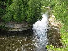
The Grand River flowing through the Elora Gorge | |
| Nearest city | Guelph |
| Coordinates | 43°40′0″N 80°27′0″W / 43.66667°N 80.45000°WCoordinates: 43°40′0″N 80°27′0″W / 43.66667°N 80.45000°W |
| Area | 145 hectares (360 acres)[1] |
| Established | 2006 |
| Governing body | Grand River Conservation Authority |

The Elora Gorge is a popular tourist attraction located at the western edge of Elora, Ontario, Canada, which is 25 km north from the city of Guelph through highway 6.
As the Elora Gorge Conservation Area, it is one of many conservation areas maintained by the Grand River Conservation Authority.
About
The Grand River flows through the bottom of the gorge, approximately 2 kilometres (1.2 mi) long, with limestone cliffs reaching 22 metres (72 ft) high.[2] It was formed from glacial meltwaters from the previous ice age. The area includes a park with camping sites, hiking trails, and is also popular for kayaking and tubing.
Located near by is the "old swimming hole", at the Elora Quarry Conservation Area, a 0.8 hectare (two acre) former limestone quarry encircled by sheer cliffs up to 12 metres (39 ft) high. Elora Quarry did not become a conservation area until 1976, but it was a popular swimming area long before that.
Popular activities at the site include: camping, canoeing, fishing, hiking, cycling, swimming, picnicking, and tubing.
Notes
- ↑ World Database on Protected Areas
- ↑ "Elora Gorge Conservation Area". Grand River Conservation Authority. Retrieved 2008-05-18.
References
- Hewitt, K. (1995). Elora Gorge: A Visitor's Guide. Boston Mills Press. p. 80.
External links
- Elora Gorge Conservation Area
- Official web Page of the Village of Elora*
- Fergus Elora Tourism
- Elora Gorge Photo Gallery
- Whitewater kayaking and tubing at Elora Gorge Conservation area
| National parks |  | |
|---|---|---|
| Provincial parks | ||
| Conservation areas | ||
| UNESCO Biosphere Reserves | ||
| National Historic Sites of Canada | ||
| Other areas | ||