Elmdon
- See also, Elmdon, West Midlands.
| Elmdon | |
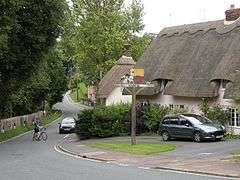 Elmdon village |
|
 Elmdon |
|
| Population | 610 (2011 Census)[1] |
|---|---|
| OS grid reference | TL465395 |
| District | Uttlesford |
| Shire county | Essex |
| Region | East |
| Country | England |
| Sovereign state | United Kingdom |
| Post town | SAFFRON WALDEN |
| Postcode district | CB11 4 |
| Police | Essex |
| Fire | Essex |
| Ambulance | East of England |
| EU Parliament | East of England |
Coordinates: 52°02′04″N 0°08′03″E / 52.03456°N 0.13429°E
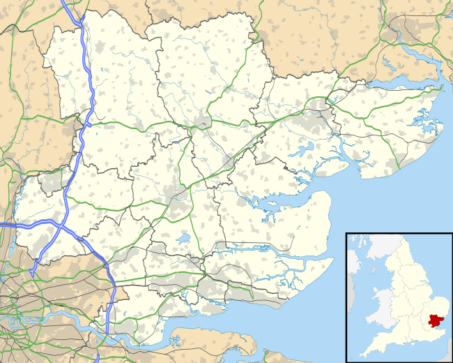
Elmdon is a village in the Uttlesford district of Essex, England, near the boundary with Cambridgeshire and Hertfordshire. The undulating nature of the local topography differentiates it from countryside to the north which is predominantly fenland and flat.
The castle motte at Elmdon, to the north-west of the church, known as 'castle hill' still exists. It was the Norman fortification of Robert de Lucy, brother to Richard de Lucy, Justiciar to King Stephen and Henry II. The church at Elmdon was granted by Robert de Lucy to Lesnes Abbey (founded by Richard de Lucy), around 1180. One mile to the west, at the highest point in Essex, Eustace de Boulogne (d1125) built and occupied his moated house named "Flanders" at Chrishall and it was there that his daughter Matilda de Boulogne (c1103-1152) the future wife of King Stephen was raised.
The name means 'hill of elms' and this village homes the only three elm trees in Essex. Elmdon includes a village hall, a church, and a recreation ground used for cricket and football. It previously contained a pub/restaurant, the Elmdon Dial, now closed. There are bus links to Bishop's Stortford.
Transport
Elmdon has an infrequent bus service and almost all residents rely on private vehicles to travel to and from the village. There are three roads out of Elmdon, two of which are minor roads leading to other villages with the third providing access indirectly to the nearest station (Audley End on the Cambridge to London Liverpool Street line).
Utilities
Elmdon is not served by mains gas, with houses relying on individually supplied heating oil systems. The village is connected to British Telecom's backbone network through the Chrishall exchange which is ADSL enabled. At January 2007 speeds of up to 2mb ADSL and 3mb ADSL-MAX were available through broadband over copper phone cable. No cable television providers service the village and given the remote location and small population it is unlikely that any will do so.
Communications
Television and radio reception is weak and varies within the village with houses in the higher (north and west) areas having stronger reception. In these areas Freeview and DAB reception is possible with passive aerials. Satellite is the only option available for non terrestrial television, a visual survey suggests that one in four households make use of this.
Leisure
Elmdon has sporting teams participating in local leagues. The village is a starting point for cross country running with trails of between 3 km and 30 km, some avoiding major roads. Tracks are passable on foot and bicycle between March and November, becoming waterlogged outside this range (passable but not to run on)
The Icknield Way Path passes through the village on its 110 mile journey from Ivinghoe Beacon in Buckinghamshire to Knettishall Heath in Suffolk. The Icknield Way Trail, a multi-user route for walkers, horse riders and off-road cyclists also passes close to the village.
See also
References
- ↑ "Parish population 2011". Retrieved 28 September 2015.
- Elmdon by Jean Robin, published by Cambridge University Press. A detailed outlook on Elmdon between 1861 and 1964 including censuses, records, statistics and changes. ISBN 0-521-22820-4
- Kinship at the Core: An Anthropology of Elmdon, a Village in North-west Essex in the Nineteen-Sixties by Marilyn Strathern and Audrey Richards, published by Cambridge University Press in 1981.
External links
| Wikimedia Commons has media related to Elmdon. |
- Elmdon village history
- Elmdon Parish Church Picture taken by Ian Rose in 1999
- The Icknield Way Parish (includes Elmdon)
- The Elmdon Dial sundial
- Elmdon Village Website