Epping, Essex
| Epping | |
 High street, and church of Saint John the Baptist |
|
 Epping |
|
| Area | 7.73 km2 (2.98 sq mi) |
|---|---|
| Population | 11,047 (civil parish, 2001)[1] 11,461 (civil parish 2011)[2] |
| – density | 1,429/km2 (3,700/sq mi) |
| OS grid reference | TL455025 |
| – London | 17 mi (27 km) SW |
| Civil parish | Epping |
| District | Epping Forest |
| Shire county | Essex |
| Region | East |
| Country | England |
| Sovereign state | United Kingdom |
| Post town | EPPING |
| Postcode district | CM16 |
| Dialling code | 01992 |
| Police | Essex |
| Fire | Essex |
| Ambulance | East of England |
| EU Parliament | East of England |
| UK Parliament | Epping Forest |
| Website | Epping Town Council |
Coordinates: 51°42′01″N 0°06′31″E / 51.7004°N 0.1087°E
Epping is a market town and civil parish in the Epping Forest district of the County of Essex, England. It is located 3 miles (5 km) northeast of Loughton, 5 miles (8 km) south of Harlow and 11 miles (18 km) northwest of Brentwood.
Although it is the terminus for London Underground's Central Line , the town retains some elements of rurality, being surrounded by Epping Forest and working farmland. Epping has many very old buildings, some of which are Grade I and II listed buildings. The town also retains its weekly market which is held every Monday and dates back to 1253.[3] In 2001 the parish had a population of 11,047[1] although this has increased marginally since then to 11,461 at the 2011 Census[2]
Epping has been twinned with the German town of Eppingen in north-west Baden-Württemberg since 1981.[4] Although the once-famous Epping Butter, which was highly sought after in the 18th and 19th centuries, is no longer made, the well-known Epping sausages are still manufactured by Church's Butchers who have been trading on the same site since 1888.[5][6]
History
"Epinga", a small community of a few scattered farms and a chapel on the edge of the forest, is mentioned in the Domesday Book of 1086. However, the settlement referred to is known today as Epping Upland. It is not known for certain when the present-day Epping was first settled. By the mid-12th century a settlement known as Epping Heath (later named Epping Street), had developed south of Epping Upland as a result of vigorous clearing of the forest for cultivation. In 1253 King Henry III conveyed the right to hold a weekly market in Epping Street which helped to establish the town as a centre of trade and has continued to the present day (the sale of cattle in the High Street continued until 1961).[7]
The linear village of Epping Heath developed slowly into a small main-road town and by the early 19th century considerable development had taken place along what is now High Street and Hemnall Street. (Hemnall Street was until 1894 in the parish of Theydon Garnon, as was the railway station) Up to 25 stagecoaches and mailcoaches a day passed through the town from London en route to Norwich, Cambridge and Bury St. Edmunds. In the early 19th century, 26 coaching inns lined the High Street.[8] A couple survive today as public houses, e.g. The George and Dragon and The Black Lion. The advent of the railways put an end to this traffic and the town declined, but it revived after the extension of a branch line from Loughton in 1865 and the coming of the motor car.
A number of listed buildings, most dating from the 18th century, line both sides of the High Street although many were substantially altered internally during the 19th century. Some of the oldest buildings in the town can be found at each end of the Conservation Area, e.g. Beulah Lodge in Lindsey Street (17th century), and the attractive group of 17th and early 18th century cottages numbered 98–110 (even) High Street.[9]
The original parish church, first mentioned in 1177, was All Saints' in Epping Upland, the nave and chancel of which dates from the 13th Century.[10] In 1833, the 14th-century chapel of St John the Baptist in the High Road was rebuilt in the Gothic Revival style. It became the parish church of Epping in 1888 and was again rebuilt. A large tower was added in 1909.[11]
Today
Epping, as it stands today, has grown as a favoured town of residence for those who work in London. Its market still brings shoppers in from surrounding villages and towns every Monday. Perhaps the most prominent building in Epping these days is the District Council's office with its clock tower, designed to bring balance to the High Street with the old Gothic Revival water tower at the southern end, built in 1872, and St John's Church tower in the centre. The centre of Epping on and around the High Street is a designated conservation area.[12]
Epping's increasing popularity with young professionals and families, along with the Government's planning policies (as applied by the District Council) has led to the current situation: Epping is experiencing the biggest threat to its rural status yet and a number of sites (the largest being St. Margaret’s Hospital) are being proposed for redevelopment as new housing estates.
The various developments would see Epping’s housing stock rise by around 20% and has caused strong opposition from residents who wish to retain Epping’s rural ‘charm’, they state the town does not have the infrastructure to cope with a large influx of new residents and vehicles. Residents point to the regular traffic congestion, lack of parking spaces (and those taken up by commuters from all over who use the railhead), low water pressure and total lack of an NHS dentist as examples. This opinion has been echoed by Epping Town Council, who have stated that Epping will not be able to cope with any new housing estates for at least 10 years.[13]
There has been a new raft of eateries entering the town in recent months and the quality of those places has, and will continue to bring visitors to the town. Pivaz a smart and traditional Turkish restaurant has already proved to be a success with locals and The Little Kitchen opens its doors in December 2016 - The independent delicatessen and coffee shop is run by an Epping family and hosts a children's play area so parents can eat comfortably knowing their little ones are having fun and not running amuck.
Governance
Epping is part of the Epping Forest parliamentary constituency, represented by Conservative MP Eleanor Laing. From 1924 to 1945, the old Epping division of Essex (which included Woodford, Chingford, Harlow and Loughton as well as Epping) was represented by Winston Churchill. It now sits in the Epping and Theydon Bois division of Essex County Council which is Liberal Democrat held. The town is divided into two district council wards. Epping Hemnall encompasses most of the town south-east of Epping High Street (B1393) including Ivy Chimneys, Fiddlers Hamlet and Coopersale. The rest of Epping lies in Epping Lindsey and Thornwood ward, as does Thornwood in the adjacent parish of North Weald Bassett. Both wards elect three councillors each.
As well as the county and district councils, Epping has a town council consisting of 12 councillors, six each elected from Epping Hemnall and Epping Lindsey wards, one of which is elected Mayor of Epping and acts as Chairman of Council, as well as a civic and ceremonial head of the local community. Epping is a successor parish, created in 1974 when the Epping Urban District was abolished.
Epping Forest District Council's headquarters are located in Epping High Street.[14]
Geography
Epping lies 19 miles (30.6 km) northeast of the centre of London towards the northern end of Epping Forest on a ridge of land between the River Roding and River Lea valleys. Epping is north of the small village of Theydon Bois.
Most of the population live in the built up area centred on and around the High Street (B1393) and Station Road. About a thousand people live in the village of Coopersale which, while physically separated from Epping by forest land, is still part of the civil parish. A few dozen households make up the hamlets of Coopersale Street and Fiddlers Hamlet. Much of the eastern part of the present parish was until 1895 in the parish of Theydon Garnon.
The Town lies north-east of junction 26 (Waltham Abbey, Loughton A121) of the M25 motorway and south-west of junction 7 (Harlow) of the M11 motorway.
Transport
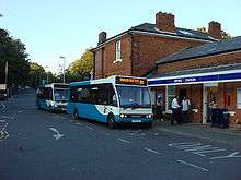
Epping is served by a number of bus routes, serving many surrounding towns and villages including; Thornwood Common, Harlow, Abridge, Waltham Abbey, Ongar and Brentwood. The bus services are either commercial services (routes 7/7A/7B, 19/20/21, 575 and X5), or operated under contract to Essex County Council (routes 213, 381/382, 501 and 541].
Epping is served by Transport for London rail services, and is the eastern terminus of the Central line of the London Underground. The Central line now terminates at Epping. However until 30 September 1994, it used to serve stations at North Weald, Blake Hall (until 1981) and Ongar where services terminated. The station has a car park with 508 spaces (the second largest car park on the London Underground network),[15] a toilet, a ticket machine, a pay phone as well as seats for sitting outside of the station to wait for buses.
Main Line train services are available from a number of neighbouring towns, with the closest stations to Epping being Roydon, Harlow and Waltham Cross, these are served by the West Anglia Main Line and are operated by Abellio Greater Anglia.
Education
- St John's Church of England Voluntary Controlled School, the only secondary school in Epping, is now designated as a specialist Engineering College. The school has an active charity fundraising group led by a Student Executive team. In 2006 two students were awarded the Rotary Prize for 'Service to School' by the local Epping Rotary Club.
- Coopersale Hall School, a private primary school at the end of Flux's Lane, Epping.[16]
- Ivy Chimneys Primary School, a primary school located in Ivy Chimneys, Epping.
- Epping Junior School.
- Coopersale and Theydon Garnon C.E. (Vol.Cont.) Primary School. A primary school located in Coopersale village.
Sport
Epping Town played in the Isthmian League until folding during the 1984–85 season. Epping FC currently play in the Essex Olympian League. Both have played at Stonards Hill.
Notable residents
- Jill Barklem, writer and illustrator
- Nick Berry, actor
- James Buckley, actor
- David Byron, former lead singer of rock band Uriah Heep
- Winston Churchill, Member of Parliament for the town and the larger constituency named after it from 1924–1945, including his tenure as Prime Minister during World War II
- Crass, band
- Philip Hammond, politician
- Glenn Hoddle, former professional football player and manager
- Rik Mayall, comedian, actor and writer, born in the town.
- Jason Merrells, actor
- Julian Mitchell, screenwriter and novelist
- Griff Rhys Jones, TV presenter and comedian
- Dennis Rofe, former professional footballer
- Ben Shephard, television presenter
- Lisa Snowdon, model
- Rod Stewart, singer
- Jessie Wallace, actress
- Bradley Walsh, actor and television presenter
- Adrian Whitbread, football coach for Puerto Rico FC
Trivia
- Epping's famous weekly market changed from being held every Monday to every Friday from 1575 up until just after the First World War, at which point it returned to being held on Monday.[17]
- Epping is the starting point for the Essex Way, which is a long distance path between Epping and Harwich.[18]
- Epping is home to the first ever Clinton Cards shop which was opened in 1968.[19]
- Epping is home to Hallows End Haunt. An annual Halloween Home Haunt set up by a local family to give members of the community a safe place to trick or treat. For more information Hallows End Haunt, Epping, Essex can be found on Facebook.
See also
.jpg)
Location grid
 |
Harlow | | ||
| Waltham Abbey | |
Chipping Ongar | ||
| ||||
| | ||||
| Theydon Bois |
References
- Epping Forest District Council (2005). Key Facts: 2001 Census (PDF). Archived from the original (PDF) on 17 February 2006.
- Epping Town Guide. Plus Publishing Services (on behalf of Epping Town Council. 2002.
- Jenkins (2001). Churchill. Macmillan. pp. 391–392. ISBN 0-330-48805-8.
- Parish Profile: Epping – information about Epping from the 2001 census (PDF file)
Notes
- 1 2 Parish Profile : Epping Archived 13 November 2004 at the Wayback Machine.
- 1 2 "Civil Parish population 2011". Neighbourhood Statistics. Office for National Statistics. Retrieved 2 September 2016.
- ↑ Archived 28 August 2008 at the Wayback Machine.
- ↑ "Epping Town Guide". Eppingtowncouncil.gov.uk. Retrieved 26 March 2013.
- ↑ "Butchers is the 100th business to sign up". Epping Forest District Council. Retrieved 1 May 2014.
- ↑ "History – Church's Butchers Ltd". Church's Butchers. Retrieved 1 May 2014.
- ↑ "Epping – Economic history and local government | A History of the County of Essex: Volume 5 (pp. 127–132)". British-history.ac.uk. 22 June 2003. Retrieved 26 March 2013.
- ↑ "Epping – Introduction and manors | A History of the County of Essex: Volume 5 (pp. 114–127)". British-history.ac.uk. Retrieved 26 March 2013.
- ↑ EPPING Archived 23 November 2007 at the Wayback Machine.
- ↑ "History of the Church". Eppinguplandchurch.org.uk. Retrieved 26 March 2013.
- ↑ "Epping – Churches, schools and charities | A History of the County of Essex: Volume 5 (pp. 132–140)". British-history.ac.uk. 25 June 1912. Retrieved 26 March 2013.
- ↑ "Epping Conservation Area" (PDF). Archived from the original (PDF) on 27 March 2009. Retrieved 27 May 2008.
- ↑ "EPPING: 'Decade until town is ready for development' (From East London and West Essex Guardian Series)". Guardian-series.co.uk. 4 August 2008. Retrieved 5 January 2010.
- ↑ information@eppingforestdc.gov.uk. "Epping Forest District Council Home Page". Eppingforestdc.gov.uk. Retrieved 5 January 2010.
- ↑ "Epping station to be refurbished and improved". Transport for London. Retrieved 17 October 2016.
- ↑ "Coopersale Hall School". Retrieved 14 April 2016.
- ↑ "Epping – Economic history and local government | British History Online". British-history.ac.uk. 22 June 2003. Retrieved 26 March 2013.
- ↑ "Essex – Places – Where the town gives way to ancient wood". BBC. 31 March 2006. Retrieved 26 March 2013.
- ↑ "About". Clinton Cards. Archived from the original on 9 February 2010. Retrieved 5 January 2010.
External links
| Wikimedia Commons has media related to Epping. |
- Epping Forest District Council
- Essex County Council
- Epping Forest – Information about Epping Forest, which is owned and managed by the City of London Corporation.
- Epping Weather – Weather records from the Epping Weather station.
- Epping to Ongar – Chronicles the history of the now defunct Ongar branch line.
- Plainly Say No – The official website of the campaign against Bellway Homes' purposed development of 351 homes on part of the St. Margaret's Hospital site.
- Photos of Epping and surrounding area on geograph.org.uk
- Epping Society a volunteer organisation protecting Epping and representing local peoples interests