Eidsvold, Queensland
| Eidsvold Queensland | |||||||||||||
|---|---|---|---|---|---|---|---|---|---|---|---|---|---|
 Eidsvold, 2011 | |||||||||||||
 Eidsvold | |||||||||||||
| Coordinates | 25°22′0″S 151°08′0″E / 25.36667°S 151.13333°ECoordinates: 25°22′0″S 151°08′0″E / 25.36667°S 151.13333°E | ||||||||||||
| Population | 630 (2011 census)[1] | ||||||||||||
| Postcode(s) | 4627 | ||||||||||||
| Location |
| ||||||||||||
| LGA(s) | North Burnett Region | ||||||||||||
| State electorate(s) | Callide | ||||||||||||
| Federal Division(s) | Flynn | ||||||||||||
| |||||||||||||
Eidsvold /ˈaɪdsvoʊld/ is a small town and locality in the North Burnett Region of Queensland, Australia.[2][3] The town is the self-proclaimed Beef Capital of the Burnett and is a hub for the regional cattle industry. In the 2011 census, Eidsvold had a population of 630 people.[1]
Geography
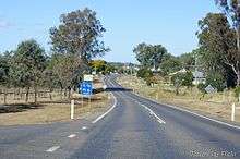
Eidsvold is situated on the Burnett Highway approximately 430 kilometres (270 mi) north of the state capital, Brisbane. The highway passes through the locality from the south-east to the north-east, passing through the town's main street (Moreton Street). The Mungar Junction to Monto branch railway passes from south-east to north-east through the locality, roughly parallel to the highway; the Eidsvold railway station serves the town.[4]
History
The town is named for Eidsvold Station, a nearby property, that is named for Eidsvoll, Norway (using the pre-1918 spelling) where the Norwegian Constitution was signed in 1814.[2] The station was given this name by the Archer brothers, settlers who had land holdings in Norway. The Eidsvold run was licensed to Thomas Archer in June 1848. The Town Reserve, 3 miles (4.8 km) east of the station homestead, was proclaimed 19 March 1890, and the post office opened 19 September 1887.[5]
At the 2006 census, Eidsvold had a population of 459.[6]
Heritage listings
Eidsvold has a number of heritage-listed sites, including:
- Eidsvold Road: Eidsvold Homestead[7]
Facilities
Eidsvold has a public library, R. M. Williams Australian bush learning centre, historical museum and complex, swimming pool, showground and bowling and golf clubs.
Gallery
 Eidsvold Shire Council members, ca. 1908
 George Beck's store and bakery, ca 1910
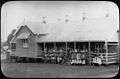 Eidsvold State School and students, 1912
References
- 1 2 Australian Bureau of Statistics (31 October 2012). "Eidsvold (SSC)". 2011 Census QuickStats. Retrieved 21 August 2016.
- 1 2 "Eidsvold - town (entry 11282)". Queensland Place Names. Queensland Government. Retrieved 20 August 2016.
- ↑ "Eidsvold - locality (entry 45346)". Queensland Place Names. Queensland Government. Retrieved 20 August 2016.
- ↑ "Queensland Globe". State of Queensland. Retrieved 21 August 2016.
- ↑ Frew, Joan (1981) Queensland Post Offices 1842-1980 and Receiving Offices 1869-1927, p. 263. Fortitude Valley, Queensland: published by the author, ISBN 0-9593973-0-2
- ↑ Australian Bureau of Statistics (25 October 2007). "Eidsvold (L) (Urban Centre/Locality)". 2006 Census QuickStats. Retrieved 25 October 2007.
- ↑ "Eidsvold Homestead (entry 600489)". Queensland Heritage Register. Queensland Heritage Council. Retrieved 12 July 2013.
External links
![]() Media related to Eidsvold, Queensland at Wikimedia Commons
Media related to Eidsvold, Queensland at Wikimedia Commons