Bundaberg
| Bundaberg Queensland | |||||||
|---|---|---|---|---|---|---|---|
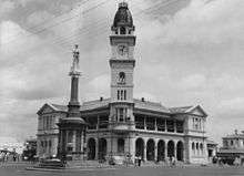
 From top left clockwise: East Water Tower, Bundaberg Post Office, War Memorial, Burnett Bridge | |||||||
 Bundaberg | |||||||
| Coordinates | 24°51′0″S 152°21′0″E / 24.85000°S 152.35000°ECoordinates: 24°51′0″S 152°21′0″E / 24.85000°S 152.35000°E | ||||||
| Population | 70,588 (2015)[1] (24th) | ||||||
| • Density | 230.91/km2 (598.04/sq mi) | ||||||
| Established | 1870 | ||||||
| Postcode(s) | 4670 | ||||||
| Area | 305.7 km2 (118.0 sq mi)[2] (2011 urban) | ||||||
| Time zone | AEST (UTC+10) | ||||||
| Location | 385 km (239 mi) from Brisbane | ||||||
| LGA(s) | Bundaberg Region | ||||||
| County | Cook | ||||||
| State electorate(s) | Bundaberg | ||||||
| Federal Division(s) | Hinkler | ||||||
| |||||||
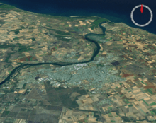
Bundaberg is a city in Queensland, Australia. It is part of the local government area of the Bundaberg Region and is a major centre within Queensland's broader Wide Bay-Burnett geographical region. The city is on the Burnett River, approximately 385 kilometres (239 mi) north of the state capital, Brisbane, and 15 kilometres (9.3 mi) inland from the coast. The local Aboriginal group is the Kalki people.
The first Europeans in the area were timbergetters and co-founders of Bundaberg, John and Gavin Steuart who arrived in 1867. The town was surveyed in 1870. By 1881 it was gazetted as a municipality (the Borough of Bundaberg). It grew rapidly into a town by 1902 and a city by 1913. At June 2015 the city had an estimated urban population of 70,588.[1]
Etymology
City name
The city name is thought to be a combination of bunda, Aboriginal word denoting an important man, and the suffix -berg (town) from the Old English beorg (hill) from the Proto-Germanic *burgs (hill fort)[3] which is also the source of the words -bury, borough, barrow.[4] The city is colloquially known as "Bundy".
Main street
Bourbong Street is the main street of the city and there is some controversy in regards to its spelling;Bourbong was alternatively spelled Boorbong, which is a Bunda Aboriginal word for a 'large waterhole'[5] possibly near the Rubyanna area.[6] The main street was historically also gazetted in the Bundaberg Mail as "Bourbon" street. Rackemann conducted a survey of letterheads printed between 1904 and 1957. Up until 1940 the count for both names was near enough to equal, with in some cases companies carrying both spelling variations in successive years. However, by 1941 there is no reference to "Bourbon" street. Farmer Robert Strathdee's farming selection in the vicinity of the watering holes was recorded on early survey maps as 'Boorbung'.[7] The Bourbong was referred to by Howitt as the name of one of the Bunda initiation ceremonies.
Another possibility is that "Bourbong" refers to "Bairbong", bair (chief) and bong meaning 'dead'. This could refer to a "place at a waterhole where a chief was speared through the eye". Historically the Kalki people referred to Bundaberg as 'Bairbara' or 'place of Chiefs'; the region was referred to as 'Borral Borral'.
History

Pre-Colonial
The local Aboriginal group is the Taribelang Bunda people. They are the inhabitants of the region which stretched from the Burrum river in the south to the Burnett river in the north. The northern side of the Burnett river was inhabited by the Gurang people whose claim area extended north to the Calliope river (Gladstone).
The Bunda moiety names were Balgoin, Barang, Bunda, Derwain and Tandor (Durrumboi in Ridley 1866); the phratry names were Kupaiathin and Dilbai. Wakka inland or wa'pa (slow speech) used the moiety name Banjurr instead of Balgoin stead (Mathew 1910). However, it has been claimed that Bunda was not a clan sub-tribe or tribe only one of the moiety names.[8]
19th Century
The first non-indigenous man to visit the region was James Davis in 1830, an escaped convict from the Moreton Bay Penal settlement. Davis was referred to as Durrumboi by the local Kabi people. He married in this area. (Rev Dunmore Lang 1861, William Ridley 1866). Alfred Dale Edwards, another early settler, was adopted into the Kalkie-speaking clan Yongkonu (Thyeebalang Roth 1910, Archibald Meston 1892). He was given the moiety name 'Bunda'. The Burnett River was identified by John Charles Burnett, after whom it was named during his exploration mission of the Wide-bay and Burnett regions in 1847.[9][10]
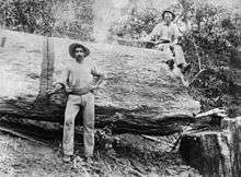
Bundaberg was founded in 1867 as a European township by timbergetters and farmers John and Gavin Steuart.[11][12] The settlement of Bundaberg originally began on the northern banks of the Burnett River in 1867 but an official survey was undertaken in 1869 and the town was re-sited onto the higher, southern banks. The first land sale held in Bundaberg occurred on 22 August 1872, although two previous sales of Bundaberg land had taken place in Maryborough. The area developed as an agricultural and port town. Initially a number of the early settlers exploited the timber on their selections but as a result of the incentives of the Sugar and Coffee Regulations 1864, sugar became a major component in Bundaberg's development from the 1870s.The first farmers in the area, including Thomas Watson, arrived soon after. Local resident and District Surveyor John Charlton Thompson was directed by the government to survey and plot an area on the South side of the river. The city was surveyed, laid out, and named Bundaberg in 1870.[12]
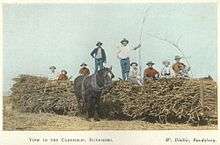
Timber was the first established industry in Bundaberg. In 1868, Samuel Johnston erected a sawmill in Waterview, on the north bank of the Burnett River (downstream from the Steuart and Watson holdings).[12][13] Waterview sawmill supplied Rockhampton as well as local needs. It became prominent enough to prompt the government to extend the railway connecting North Bundaberg with Mount Perry, eastward to the Waterview Mill. Waterview sawmill closed in 1903 after being damaged by flood.[14] Experimental sugar cane cultivation in the district followed, and a successful industry grew. The first sugar mill was opened in 1882.[15] The early sugar industry in Bundaberg was based on Kanakas workers, who were kept in a status close to slavery.
The three surveyors named Bundaberg's streets. Thompson was assisted by unregistered surveyor assistants James Ellwood and Alfred Dale Edwards.[16] Edwards preferred using aboriginal names: Kolan, Woongarra, Barolin, Bingera, Kalkie, Moolboolooman, and for streets Tantitha, Bourbong, etc.
20th Century
With the passage of the Local Authorities Act 1902, Barolin Division became the Shire of Barolin and the Borough of Bundaberg became the Town of Bundaberg on 31 March 1903. On 22 November 1913, Bundaberg was proclaimed a City.[17]
The 1911 Queensland sugar strike occurred after the phasing out of South Sea Islander labour in 1904, with workers claiming that many plantation owners had substituted black indentured labourers (sometimes referred to as slaves) with white ones. Workers sought better accommodation, wages and conditions, including an eight-hour day and a minimum weekly wage of 30 shillings, including food. The mobilisation of unionists from Bundaberg to Mossman was a major achievement, with the 1911 strike lasting over seven weeks in Bundaberg where the town's economy was largely based on the sugar industry.[18] The end result of the strike was a Commonwealth Royal Commission into the sugar industry in 1911-12, which had been initially requested by Harry Hall, a Bundaberg AWA organiser in 1908 with a petition signed by 1500 Bundaberg sugar workers.[19] The Royal Commission, with ALF Secretary Albert Hinchcliffe as secretary, concluded the AWA demands had been justified. The union victory was a watershed in organised labour in Queensland and Australia.[20][21]
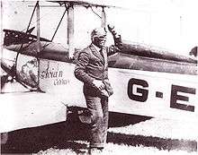
In 1912 Bundaberg pioneering aviator, Bert Hinkler builds and successfully flies his own glider on Mon Repos beach. He also completed a noteworthy non-stop flight from London to Turin in 1920. The following year in 1921 Hinkler flies from Sydney to Bundaberg, non-stop, in a record breaking flightof 8 and a half hours, in the process beating a telegram he had sent to his mother, to warn her of his arrival.[22]
The Bundaberg War Memorial commemorating those who died in the Anglo-Boer War and World War I was unveiled by Major-General Charles Brand on 30 July 1921.[23][24] The Bundaberg digger was imported from Italy and is constructed of Italian marble. The completed memorial, at a cost of £1,650, was the third most costly to be erected in Queensland. It is a major regional memorial and one of the two most intact digger memorials that remain in their original settings of intersections.
In the 1960s the township was completely flooded by the Burnett river. In 1967 Bundaberg celebrated its centenerary by producing a coin and opening the The Bundaberg & District Historical Museum in the Bundaberg Botanical Gardens in Bundaberg North.
21st Century
In December 2010, Bundaberg suffered its worst floods in 60 years, when floodwaters from the Burnett River inundated hundreds of homes.[25]
Two years later, in January 2013, Bundaberg experienced its worst flooding in recorded history. Floodwaters from the Burnett River peaked at 9.53 meters. As of 28 January 2013, more than 2000 properties had been affected by floodwaters, which moved in excess of 70 km/h. Two defence force Blackhawk helicopters were brought in from Townsville as part of the evacuation operation, which ultimately used an additional 14 aircraft.
Heritage listings
Bundaberg has a number of heritage-listed sites, including:
- Bourbong Street: Bourbong Street Weeping Figs[26]
- Bourbong Street: Bundaberg War Memorial[27]
- Bourbong Street: Bundaberg War Nurses Memorial[28]
- Bourbong Street: Kennedy Bridge[29]
- cnr Maryborough Street: St Andrews Uniting Church[30]
- Corner of Bargara Road and Zeilke Avenue: Kalkie State School[31]
- Quay Street: Bundaberg Police Station[32]
- Quay Street: Burnett Bridge[33]
- Quay Street: Saltwater Creek Railway Bridge[34]
- Sir Anthony's Rest Street: Sir Anthony's Rest[35]
- Thornhill Street: Fairymead House[36]
- 1 Maryborough Street: Fallon House[37]
- 17 Sussex Street: East Water Tower[38]
- 30 George Street: St John's Lutheran Church[39]
- 46 Johnston Street: South Sea Islander Church[40]
- 55 Woongarra Street: 4BU Radio Station[41]
- 184 Bourbong Street: Bundaberg School of Arts[42]
- 191–193 Bourbong Street: Commercial Bank[43]
- Cnr Woongarra and Maryborough streets: Christ Church, Bundaberg[9] local heritage register, Bundaberg Regional Council. The church sits adjacent to Buss park which contains a memorial to Bert Hinkler.
Geography

Climate
Bundaberg has a subtropical climate with wet hot summers and mild winters. The climate is the most equable of any Australian town or city and ranked 5th on a worldwide comparison.[12] The mean daily maximum temperature is highest in January at 30.3 °C (86.5 °F) Celsius, and the mean daily minimum is lowest in July at 9.9 °C (49.8 °F).[44] The coldest temperature recorded in Bundaberg is −0.7 °C (30.7 °F) degrees Celsius, and some inland areas of Bundaberg sometimes experience frosts. The mean annual rainfall is 1,142.6 mm (44.98 in).
| Climate data for Bundaberg Post Office | |||||||||||||
|---|---|---|---|---|---|---|---|---|---|---|---|---|---|
| Month | Jan | Feb | Mar | Apr | May | Jun | Jul | Aug | Sep | Oct | Nov | Dec | Year |
| Record high °C (°F) | 38.9 (102) |
38.3 (100.9) |
37.7 (99.9) |
34.9 (94.8) |
31.7 (89.1) |
29.7 (85.5) |
28.8 (83.8) |
30.7 (87.3) |
36.5 (97.7) |
35.8 (96.4) |
37.7 (99.9) |
40.2 (104.4) |
40.2 (104.4) |
| Average high °C (°F) | 30.3 (86.5) |
30.0 (86) |
29.3 (84.7) |
27.5 (81.5) |
24.8 (76.6) |
22.4 (72.3) |
22.0 (71.6) |
23.2 (73.8) |
25.2 (77.4) |
27.1 (80.8) |
28.7 (83.7) |
30.1 (86.2) |
26.7 (80.1) |
| Average low °C (°F) | 21.3 (70.3) |
21.2 (70.2) |
20.0 (68) |
17.4 (63.3) |
13.9 (57) |
11.3 (52.3) |
9.9 (49.8) |
10.7 (51.3) |
13.4 (56.1) |
16.5 (61.7) |
18.8 (65.8) |
20.6 (69.1) |
16.3 (61.3) |
| Record low °C (°F) | 14.1 (57.4) |
12.2 (54) |
9.7 (49.5) |
6.7 (44.1) |
3.3 (37.9) |
0.7 (33.3) |
−0.7 (30.7) |
−0.2 (31.6) |
0.2 (32.4) |
5.5 (41.9) |
7.9 (46.2) |
10.6 (51.1) |
−0.7 (30.7) |
| Average precipitation mm (inches) | 205.8 (8.102) |
173.5 (6.831) |
139.7 (5.5) |
84.1 (3.311) |
70.6 (2.78) |
65.7 (2.587) |
53.5 (2.106) |
33.4 (1.315) |
35.7 (1.406) |
62.8 (2.472) |
85.0 (3.346) |
131.0 (5.157) |
1,142.6 (44.984) |
| Average precipitation days | 10.0 | 9.6 | 9.5 | 6.6 | 5.7 | 4.3 | 4.0 | 3.5 | 3.5 | 5.2 | 6.3 | 7.9 | 76.1 |
| Average relative humidity (%) | 62 | 63 | 63 | 60 | 58 | 56 | 53 | 52 | 53 | 57 | 59 | 61 | 58 |
| Source: Bureau of Meteorology[45] | |||||||||||||
Suburbs

|
|
Economy


Subtropical Bundaberg is dependent to a large extent on the local sugar industry. Extensive sugar cane fields have been developed throughout the district. Value-adding operations, such as the milling and refinement of sugar, and its packaging and distribution, are located around the city. A local factory that manufactured sugar-cane harvesters was closed down after it was taken over by the US multinational corporation Case New Holland. Most of the raw sugar is exported.[15] A bulk terminal for the export of sugar is located on the Burnett River east of Bundaberg.
Another of the city's exports is Bundaberg Rum, made from the sugar cane by-product molasses. Bundaberg is also home to beverage producer Bundaberg Brewed Drinks and Craft Brewery Bargara Brewing Company.
Commercial fruit and vegetable production is also significant: avocado, banana, bean, button squash, capsicum, chilli, citrus, cucumber, custard apple, egg fruit, honeydew melon, lychee, mango, passionfruit, potato, pumpkin, rockmelon, snow peas, stone fruit, sweet corn, sweet potato, tomato, watermelon, zucchini.[46] Macadamia nuts are also grown.[47]
Tourism
Tourism is an important industry in Queensland, and Bundaberg is known as the 'Southern Gateway to the Great Barrier Reef'.[12] The city lies near the southern end of the reef in proximity to Lady Elliot and Lady Musgrave Islands. The nearby town of Bargara is an increasingly popular holiday and retirement destination.
The Mon Repos turtle rookery is located on the coast just east of Bundaberg. The northern bank of the Burnett River between the Don Tallon and Burnett bridges is home to a colony of flying foxes.
Nearby beaches are popular with both locals and tourists.[48] Moore Park, to the city's north, has 20 kilometres (12 mi) of golden sandy beach. Beaches on the southern side of the Burnett River are (from north to south) the Oaks Beach, Mon Repos, Nielsen Park, Bargara Beach, Kellys Beach, Innes Park and Elliott Heads.
Cania Gorge National Park, Deepwater National Park, Eurimbula National Park and Kinkuna National Park, located in the Bundaberg region are popular with campers and bush-lovers.[48]
Tours of the Bundaberg Rum distillery and attractions at Bundaberg Botanic Gardens, such as the 2 ft narrow gauge[49] Australian Sugar Cane Railway, are also popular with tourists.[48] The Mystery Craters, 35 unexplained water-filled holes in the ground, discovered in 1971 at South Kolan, are also a tourist attraction.[50]
Opened in 2002 by the former member for Hinkler Paul Neville, the Tom Quinn Community Centre gardens (a multiple "Bundy in Bloom" winner) is a site to be seen with local flora and fauna, its own cafe, marketplace, chapel, green house, training facilities, woodwork and indigenous nature section.[51]
Opened in December 2008, the Hinkler Hall of Aviation is an historical aviation tourist attraction that celebrates pioneer solo aviator Bert Hinkler. In 1928, Hinkler was the first person to fly solo from England to Australia.[52] The museum includes an exhibition hall, featuring multi-media exhibits, a flight simulator, a theatre, five aircraft and the historic Hinkler House.
Other local attractions and events include the Whaling Wall, East Bundaberg Water Tower, Baldwin Swamp Environmental Park, Alexandra Park Zoo, Barrell House, Bundy in Bloom, Whale watching, reef tours of Lady Musgrave & Lady Elliiot islands, the Bundaberg Show, Bundaberg & Childers Regional Art Galleries, the Bundaberg Gliding school, Fishing Charters, the Bundaberg International Air Show, and the Woongarra Marine Park.
Museums and galleries
The Bundaberg region contains a variety of museums and art galleries that showcase the region's history and culture.[53]
- Hinkler Hall of Aviation
- Hinkler House
- Fairymead House and Sugar History Museum
- BRAG, the Bundaberg Regional Art Gallery
- CHARTS, the Childers Art Space
- Bundaberg and District Historical Museum
- Bundaberg Railway Museum
- Bundaberg Rum Distillery Tours[54]
- Bundaberg Botanic Gardens containing the 'Hinkler Hall of Aviation', 'Hinkler House', 'Fairymead House' and the 'Bundaberg Steam Tramway Preservation Inc.'
- Mystery Craters in South Kolan
- Schmeider's Cooperage (Bundy Kegs)
- Bundaberg Ginger Beer


Memorials
- Bundaberg War Memorial
- Hinkler memorial
Culture
Arts and entertainment
Bundaberg has two cinemas. The Reading Cinemas, on Johanna Boulevarde, west Bundaberg, and the Moncrieff Entertainment Centre (formerly known as the Moncrieff Theatre), located on Bourbong Street, central Bundaberg. The Moncrieff Entertainment Centre also holds live musical and theatrical performances year round.[55]
The Bundaberg Regional Art Gallery (BRAG) is a large multi-purpose visual arts facility located in central Bundaberg.[56]
Media
The NewsMail newspaper is published in Bundaberg from Monday to Saturday. It is available in print and online.[57] Several community newspapers are also available including the Guardian,[58] The Bugle[59] & the Bundaberg Coastline[60]
- ABC Local Radio: Wide Bay 855 AM/100.1 FM – due to the terrain of the area, both AM and FM frequencies are used.
- 4BU 1332 AM (commercial) – owned by Grant Broadcasters
- Sea FM 93.1 (commercial) – part of the Today Network, owned by Southern Cross Media Group .
- Hitz FM 93.9 (commercial) – owned by Grant Broadcasters
- 4BCR 94.7 FM (community)
- 4DoubleB 96.3 FM (community)
- Kix Country 97.1 FM (narrowcast) – owned by Grant Broadcasters
- RadioTAB 95.5 FM (narrowcast) – owned by Tatts Group
- ABC Classic FM 98.5 FM
- Triple J 99.3 FM
- ABC Radio National 100.9 FM
- Rebel FM 106.7 FM (Wide Bay)
Bundaberg is served by three commercial television stations (Seven Queensland, WIN Television and Nine) and publicly owned services (ABC TV) and (SBS).
Local news coverage of Bundaberg and the Wide Bay is provided on all three commercial networks with both Seven Queensland's Seven Local News and WIN Queensland's WIN News half-hour bulletins airing at 6pm each weeknight. Southern Cross Austereo also airs brief local news updates at various intervals throughout the day on Channel 9, presented from studios in Canberra.
Popular culture
The city has been the location for two film sets, including the 1989 film, The Delinquents, starring Kylie Minogue, which was set in Brisbane, but partly shot in Bundaberg,[61] and the 1977 film, The Mango Tree.[62]
Sport
Most major Australian sporting codes are played in Bundaberg, including: rowing (sport), basketball, roller derby, cricket, golf, lawn bowls, netball, tennis, rugby union, rugby league, soccer, hockey, Australian Rules football, and softball.
Basketball – Bundaberg has two professional teams, both competing in the Australian Basketball Association's Queensland Conference (QBL). They are the Bundaberg Radiology Bulls (men) and Bundaberg Radiology Bears and both feature local players.
Tennis – The Bundaberg & District Tennis Senior Association operates eleven floodlit clay courts in Drinan Park, Bundaberg West at the corner of George & Powers Streets.[63] Competition tennis is played all year round. The Bundaberg & District Junior Tennis Association operates five artificial grass courts, and two granite courts.
Rowing – Bucca Weir, west of Bundaberg, is home to the Queensland State Rowing Championships every year in December.
Soccer – Bundaberg is home to the Bundaberg Spirit soccer club. They participate in the Queensland State League against other teams across Queensland.
Australian Rules football – Bundaberg has two current clubs playing in the AFL Wide Bay competition.
- Across The Waves Bundaberg Eagles (merger of North Bundaberg and Souths/ATW Magpies)
- Brothers Bulldogs (formerly West Bundaberg)
The other clubs in the competition are:
- Hervey Bay Bombers
- Maryborough Bears
- Bay Power
Education
There are many public and private primary schools in Bundaberg.
Bundaberg has three public high schools, Bundaberg North State High School, Bundaberg State High School (the second-oldest high school in Queensland that is still open) and Kepnock State High School. There are also three main private secondary schools: Shalom Catholic College, St Luke's Anglican School, and Bundaberg Christian College.
There is a campus of the Wide Bay Institute of Technical and further education on Walker St and a campus of the Central Queensland University, located adjacent to the airport. There is a campus of the Booth College at the Salvation Army's Tom Quinn Community Centre.[64]
Transport
Bundaberg Airport has flights to Brisbane and Lady Elliot Island. The city is home to the Jabiru Aircraft Company, which designs and manufactures a range of small civil utility aircraft.
Bundaberg's bus operator is Duffy's City Buses. As of 2013, they transport over 1000 passengers in town services, and over 2000 passengers in school services every day.[65] Routes extend to the beach suburbs of Burnett Heads, Bargara, and Innes Park. Stewart & Sons also operates bus services in the area.[66]
Bundaberg is serviced by several Queensland Rail passenger trains, including the Tilt Train and is approximately four and a half hours north of Brisbane by rail. The closed North Bundaberg station formerly served the Mount Perry railway line and is now a museum.
Bundaberg is situated at the end of the Isis Highway (State Route 3), approximately 50 kilometres (31 mi) east of its junction with the Bruce Highway. Many long-distance bus services also pass through the city.
Bundaberg Port is located 20 kilometres (12 mi) northeast of the city, at the mouth of the Burnett River. The port is a destination for ships from Australia and overseas. It is predominantly used for shipping raw sugar and other goods related to that industry such as Bundaberg Rum.
Health
Bundaberg is served by three hospitals. One public hospital, Bundaberg Base Hospital on Bourbong St, and two private hospitals, Friendly Society Private Hospital & Mater Hospital.
The Friendly Society Hospital has undergone a redevelopment and forms part of the GP Super Clinic Program.
Bundaberg is also home to the Royal Flying Doctor Service, who regularly transport patients to Bundaberg from more rural and remote areas, as well as transferring critically ill patients to Brisbane for specialist care.
Sister cities
The city council responsible for the Bundaberg Region maintains Sister City arrangements with two cities.[67]
| City | Since |
|---|---|
| | 12 May 1988 |
| | 9 November 1988 |
People
Notable residents
.jpg)
- Courtice Benjamin (1885–1972) politician, farmer [68]
- Clint Bolton, association football player, Socceroo, 2 time A-League championship winning player
- Mark Callaghan, frontman of Gang Gajang
- Wayne Coles-Janess, producer and director, documentary and feature films
- Allan Davis, Road racing cyclist, 2009 Tour Down Under Winner
- Troy Elder, Hockey player
- Steve Goodall, cyclist, 1978 Commonwealth Games Bronze Medalist, 1976 Olympian
- Bert Hinkler, pioneer aviator
- Antonio Kaufusi, rugby league footballer
- Mitchell Langerak, association football player, A-League championship winning player
- Errol McCormack, retired Chief of Air Force (1998–2001), Officer of the Order of Australia (1998)
- Rheed McCracken, 2012 Summer Paralympics, won a silver and bronze medal
- Sarah McLellan, dancer and entertainer, lead singer of the group Lez Zeppelin and blogger of "The Aussie who ate the Big Apple" currently living in New York
- Mal Meninga, rugby league footballer
- Tom Miles, professional athlete/sprinter, Winner 1927 Stawell Gift, 1928 World Champion
- Gladys Moncrieff, singer
- Clinton Moore, Freestyle Motorcross Rider
- Ben Nedwich, Australian Apprentice (Trainee) of the Year 2016,[69] Australian Apprenticeship Ambassador,[70] WorldSkills Australia Business Services National Champion 2016[71]
- Edward Vivian Palmer,(1885–1959) writer [72]
- Vance Palmer, writer
- Jayant Patel, the alleged "Doctor Death" of the Bundaberg Base Hospital
- Ian Quinn, Golden Guitar winner & singer/songwriter
- Daniel Ronan, 2000 Summer Olympics - Volleyball
- Chris Sarra, 2004 Queenslander of the Year
- Donald Smith, operatic tenor
- Michelle Steele, Winter Olympian at the 2006 Winter Olympics
- Don Tallon, Australian Cricketer
- Keith Thiele, World War II Pilot (awarded DSO, DFC & 2 medal bars)
- Tommy Trash, ARIA and Grammy nominated Australian DJ & Producer
Representatives
Current
- Leanne Donaldson, (Australian Labor Party), State member for Bundaberg
- Keith Pitt (Liberal National Party of Queensland), Federal member for Hinkler
Former
- Prime Ministers Andrew Fisher and Frank Forde both represented Federal electorates that included Bundaberg, though neither was originally from the area.
Notes
- 1 2 "3218.0 – Regional Population Growth, Australia, 2014-15: Population Estimates by Significant Urban Area, 2005 to 2015". Australian Bureau of Statistics. Australian Bureau of Statistics. 30 March 2016. Retrieved 12 September 2016. Estimated resident population, 30 June 2015.
- ↑ "2011 Census Community Profiles: Bundaberg". ABS Census. Australian Bureau of Statistics. Retrieved 15 September 2016.
- ↑ "Online Etymology Dictionary". www.etymonline.com. Retrieved 2016-03-07.
- ↑ "Place Name Details" (PHP). Natural Resources and Water (Queensland). 2008. Retrieved 13 March 2008.
- ↑ (Cairns Post, 1910 P7 18 Jan W.A. Dean)
- ↑ Bundaberg History and People. (1978) Janet Nolan. p 86
- ↑ Rackemann (1992), Bundaberg, p. 48
- ↑ "The Derivation of "Bundaberg.".". The Queenslander (Brisbane, Qld. : 1866 - 1939). Brisbane, Qld.: National Library of Australia. 7 May 1892. p. 891. Retrieved 23 January 2016.
- 1 2 http://www.bundaberg.qld.gov.au/files/Christ_Church_Bundaberg.pdf
- ↑ "Christ Church, Bundaberg" (PDF). Bundaberg Regional Council. Retrieved 28 May 2015.
- ↑ "Bundaberg".
- 1 2 3 4 5 "History of Bundaberg". Bundaberg Regional Council. Retrieved 21 September 2010.
- ↑ "HISTORY OF BUNDABERG". Bundaberg Regional Council. Retrieved 26 December 2013.
- ↑ Kerr, John (1998). "Report on Site Visits" (PDF): 298. Retrieved 26 December 2013.
- 1 2 Hall, James; Dening, Jill (1988). Beautiful Sugar Country. West End, Queensland: Child & Associates Publishing. p. 2. ISBN 0-949267-86-4.
- ↑ Bundaberg – From Pioneers to Prosperity. (1992) Neville Rackemann. p46 ISBN 0-646-12555-9
- ↑ Queensland Government Gazette, Vol. CL, 22 November 1913, p.1422.
- ↑ Janette Nolan, Bundaberg, history and people, St Lucia: University of Queensland press, 1978, p. 147.
- ↑ Brisbane Courier, 21 October 1908, p.5; Nolan, p. 146.
- ↑ "Fallon House (entry 602814)". Queensland Heritage Register. Queensland Heritage Council. Retrieved 1 August 2014.
- ↑ Dr K H Kennedy, "The Rise of the Amalgamated Workers Association" in Lectures on North Queensland History, James Cook University, Second Series 1975, pp. 198-199.
- ↑ O'Connor, T. (1996). A Pictorial History Of Queensland. Brisbane: Robert Brown & Associates (Qld) Pty Limited, pp.271-272.
- ↑ "Bundaberg Soldiers' Memorial.". Queensland Times (Ipswich) (Qld. : 1909 – 1954). Ipswich, Qld.: National Library of Australia. 1 August 1921. p. 6 Edition: DAILY. Retrieved 6 April 2014.
- ↑ "Bundaberg War Memorial". Monument Australia. Retrieved 6 April 2014.
- ↑ Calligeros, Marissa and Cameron Atfield (30 December 2010). "Second Queensland town evacuated due to floodwater". The Sydney Morning Herald. Fairfax. Retrieved 30 December 2010.
- ↑ "Bourbong Street Weeping Figs (entry 602065)". Queensland Heritage Register. Queensland Heritage Council. Retrieved 7 July 2013.
- ↑ "Bundaberg War Memorial (entry 600364)". Queensland Heritage Register. Queensland Heritage Council. Retrieved 7 July 2013.
- ↑ "Bundaberg War Nurses Memorial and Park (entry 600365)". Queensland Heritage Register. Queensland Heritage Council. Retrieved 7 July 2013.
- ↑ "Kennedy Bridge (entry 600367)". Queensland Heritage Register. Queensland Heritage Council. Retrieved 7 July 2013.
- ↑ "St Andrews Uniting Church (entry 602489)". Queensland Heritage Register. Queensland Heritage Council. Retrieved 7 July 2013.
- ↑ "Kalkie State School (entry 600971)". Queensland Heritage Register. Queensland Heritage Council. Retrieved 7 July 2013.
- ↑ "Bundaberg Police Station Complex (former) (entry 601762)". Queensland Heritage Register. Queensland Heritage Council. Retrieved 7 July 2013.
- ↑ "Burnett Bridge (entry 600368)". Queensland Heritage Register. Queensland Heritage Council. Retrieved 7 July 2013.
- ↑ "Saltwater Creek Railway Bridge (entry 600370)". Queensland Heritage Register. Queensland Heritage Council. Retrieved 7 July 2013.
- ↑ "Sir Anthony's Rest (entry 602053)". Queensland Heritage Register. Queensland Heritage Council. Retrieved 7 July 2013.
- ↑ "Fairymead House (entry 601009)". Queensland Heritage Register. Queensland Heritage Council. Retrieved 7 July 2013.
- ↑ "Fallon House (entry 602814)". Queensland Heritage Register. Queensland Heritage Council. Retrieved 7 July 2013.
- ↑ "East Water Tower (entry 600369)". Queensland Heritage Register. Queensland Heritage Council. Retrieved 7 July 2013.
- ↑ "St John's Lutheran Church, Bundaberg (entry 602815)". Queensland Heritage Register. Queensland Heritage Council. Retrieved 7 July 2013.
- ↑ "South Sea Islander Church and Hall (entry 602052)". Queensland Heritage Register. Queensland Heritage Council. Retrieved 7 July 2013.
- ↑ "4BU Radio Station (former) (entry 601284)". Queensland Heritage Register. Queensland Heritage Council. Retrieved 7 July 2013.
- ↑ "Bundaberg School of Arts (entry 600362)". Queensland Heritage Register. Queensland Heritage Council. Retrieved 7 July 2013.
- ↑ "Commercial Bank of Sydney (former) (entry 600363)". Queensland Heritage Register. Queensland Heritage Council. Retrieved 7 July 2013.
- ↑ Climate Statistics for Australian Locations, Bureau of Meteorology
- ↑ "Climate statistics for Australian locations". Bureau of Meteorology. Retrieved 1 April 2014.
- ↑ "What's Growing?". Bundaberg Fruit and Vegetable Growers. Retrieved 27 December 2013.
- ↑ "Electra going nuts for macadamias". Bundaberg NewsMail. 28 May 2013. Retrieved 27 December 2013.
- 1 2 3 Vanessa Marsh (17 December 2009). "Bundaberg region a tourist haven". NewsMail. APN News & Media. Retrieved 21 September 2010.
- ↑ "Australian Sugar Cane Railway (ASCR), Bundaberg". qldrailheritage.com.
- ↑ "Mystery Craters". Tourism Queensland. Retrieved 21 September 2010.
- ↑ "TQCC » salvos.org.au/bundaberg/".
- ↑ Cook, Penny (2006). Discover Queensland Heritage. Corinda, Queensland: Pictorial Press Australia. p. 29. ISBN 1876561424.
- ↑ "Bundaberg City Galleries, Museums and Collections Attractions - Bundaberg Region QLD". bundabergregion.org.
- ↑ "Tours". www.bundabergrum.com.au. Retrieved 22 January 2016.
- ↑ "Moncrieff Entertainment Centre". Retrieved 25 June 2012.
- ↑ "Bundaberg Regional Art Gallery". Retrieved 25 June 2012.
- ↑ "NewsMail". Retrieved 25 June 2012.
- ↑ "Guardian". apnarm.com.au.
- ↑ "Bugle Newspaper". TrueLocal.com.au.
- ↑ "Coastline Newspaper Group - Home". coastlinenews.com.au.
- ↑ imdb page for The Delinquents Retrieved 9 March 2014
- ↑ imdb page for The Mango Tree Retrieved 9 March 2014
- ↑ "Tennis Bundaberg Website" (PHP). Bundaberg & District Tennis Senior Association. 2008. Retrieved 21 December 2008.
- ↑ "Tom Quinn Community Centre, Bundaberg".
- ↑ "Duffy's City Buses". Duffy's City Buses. Retrieved 20 February 2013.
- ↑ "Stewart and Sons Coaches". stewarts-coaches.com.au.
- ↑ bundaberg.qld.gov.au/sistercity, Bundaberg Regional Council. Retrieved 4 September 2014.
- ↑ ^ Elaine Brown, 'Courtice, Benjamin (1885–1972)', Australian Dictionary of Biography, National Centre of Biography, Australian National University, http://adb.anu.edu.au/biography/courtice-benjamin-9840/text17405, 1993, accessed online 30 March 2015.
- ↑ Australian Training Awards, https://www.australiantrainingawards.gov.au/finalists/ben-nedwich-queensland
- ↑ Australian Apprenticeship Ambassador, https://www.australianapprenticeships.gov.au/australian-apprenticeships-ambassadors-program
- ↑ WorldSkills Australia, http://www.worldskills.org.au/results-2016-worldskills-australia-national-competition/
- ↑ Geoffrey Serle, 'Palmer, Edward Vivian (Vance) (1885–1959)', Australian Dictionary of Biography, National Centre of Biography, Australian National University, http://adb.anu.edu.au/biography/palmer-edward-vivian-vance-7946/text13831, 1988, accessed online 30 March 2015.
External links
| Wikimedia Commons has media related to Bundaberg, Queensland. |
| Wikivoyage has a travel guide for Bundaberg. |
- Bundaberg Regional Council
- University of Queensland: Queensland Places: Bundaberg
- Bundaberg Port Authority
- "The Districts of Queensland (15).". Queensland Country Life (Qld. : 1900 - 1954). Qld.: National Library of Australia. 1 December 1901. p. 9. Retrieved 14 November 2015. — A description of Bundaberg in 1901