Edmonson, Missouri
| Edmonson, Missouri | |
|---|---|
| Unincorporated community | |
 Edmonson, Missouri | |
| Coordinates: 38°18′34″N 93°13′27″W / 38.30944°N 93.22417°WCoordinates: 38°18′34″N 93°13′27″W / 38.30944°N 93.22417°W | |
| Country | United States |
| State | Missouri |
| County | Benton |
| Elevation | 774 ft (236 m) |
| Time zone | Central (CST) (UTC-6) |
| • Summer (DST) | CDT (UTC-5) |
| Area code(s) | 660 |
| GNIS feature ID | 717409[1] |
Edmonson is an unincorporated community in Benton County, Missouri, United States. Edmonson is located at the junction of Supplemental Routes H and W 8.2 miles (13.2 km) southeast of Lincoln.[2]
A post office called Edmonson was established in 1886, and remained in operation until 1916.[3] The community has the name of a local familty.[4]
References
- ↑ "Edmonson". Geographic Names Information System. United States Geological Survey.
- ↑ Benton County General Highway Map (PDF) (Map). Missouri Department of Transportation. 2005. Retrieved May 23, 2012.
- ↑ "Post Offices". Jim Forte Postal History. Retrieved 1 September 2016.
- ↑ Eaton, David Wolfe (1916). How Missouri Counties, Towns and Streams Were Named. The State Historical Society of Missouri. p. 210.
Municipalities and communities of Benton County, Missouri, United States | ||
|---|---|---|
| Cities | 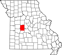 | |
| Village | ||
| Townships |
| |
| Unincorporated communities |
| |
| Former settlements | ||
| Footnotes | ‡This populated place also has portions in an adjacent county or counties | |
This article is issued from Wikipedia - version of the 10/24/2016. The text is available under the Creative Commons Attribution/Share Alike but additional terms may apply for the media files.