Edgware Way Grassland
Edgware Way Grassland or Edgware Way Rough is a 6.7 hectare Site of Metropolitan Importance for Nature Conservation in Edgware in the London Borough of Barnet.[1] It is traversed by Edgwarebury Brook and contains traces of a planned railway viaduct and embankment.[2] This was part of a proposed railway between Edgware and Bushey,[3] which was cancelled when the introduction of the Green Belt after the Second World War led to the cancellation of the developments which the railway was to serve. Part of the site is the Environment Agency's Edgwarebury Park Flood Storage Area.
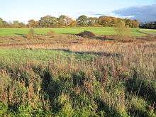
The reserve is typical unimproved London Clay grassland. Damp, herb rich areas have uncommon plants characteristic of old meadows such as great burnet, sneezewort and devil's bit scabious. The brook is lined by sedges and water-cress, while breeding birds include yellowhammer and spotted flycatcher.[2]
The reserve adjoins Edgwarebury Park. It is private land, but is crossed by a public footpath from Edgware Way which starts just west of the junction with Spur Road.
See also
References
- ↑ "iGiGL – helping you find London's parks and wildlife sites". Greenspace Information for Greater London. 2006.
- 1 2 "Edgware Way Rough". Greenspace Information for Greater London. 2006. Retrieved 9 September 2012.
- ↑ Edgwarebury Park, London Gardens Online
Further reading
- Hewlett, Janet (1997). Nature Conservation in Barnet. London Ecology Unit. ISBN 1 871045 27 4.
Coordinates: 51°37′29″N 0°17′17″W / 51.6248°N 0.2881°W