Eastcotts
| Eastcotts | |
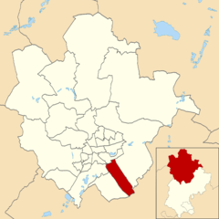 Eastcotts parish within Bedford |
|
 Eastcotts |
|
| Population | 3,239 (2011 Census including Harrowden and Shortstown)[1] |
|---|---|
| OS grid reference | TL083344 |
| Unitary authority | Bedford |
| Ceremonial county | Bedfordshire |
| Region | East |
| Country | England |
| Sovereign state | United Kingdom |
| Post town | BEDFORD |
| Postcode district | MK42 |
| Police | Bedfordshire |
| Fire | Bedfordshire and Luton |
| Ambulance | East of England |
| EU Parliament | East of England |
| UK Parliament | North East Bedfordshire |
|
|
Coordinates: 52°05′51″N 0°25′05″W / 52.097597°N 0.418091°W
Eastcotts is a civil parish in the county of Bedfordshire.
The boundaries of Eastcotts are approximately Exeter Wood to the east, Brink Cycleworks to the south and Shocott Spring to the west. There are two woodlands; Shocott Spring and Exeter Wood, two villages; Shortstown and Cotton End and two hamlets; Harrowden and Herrings Green. And some landmarks such as the Cardington Sheds.
History
Eastcotts Castle a small motte castle constructed of timber was built during the 11th or 12th centuries. Located on the Bedfordshire Greensand Ridge, it overlooked the parish to the north.[2]
In 1831 Eastcotts was described as a chapelry in the parish of Cardington, in the hundred of Wixamtree, 3½ miles south-east of Bedford.[3]
In 1915 Short Brothers bought land in the parish to build airships for the Admiralty and constructed a 700-foot-long (210 m) airship hangar to build the two R31 class airships. They also built a housing estate for workers which they named Shortstown. The site was nationalized in 1919 and became known as the Royal Airship Works. The shed was extended in 1926 and its roof was raised to accommodate the R101. A second shed was moved here from RNAS Pulham, Norfolk,in 1928, but after the crash of the R101 in 1930, all work stopped in Britain on airships and the site became a storage station. It became known as RAF Cardington in 1936 and started building barrage balloons and became the No 1 RAF Balloon Training Unit. The site has since been used for a variety of other purposes by a number of organizations including the Royal Aircraft Establishment, the Building Research Establishment, the Meteorological Research Unit, Airship Industries and Hybrid Air Vehicles. The sheds are both listed buildings,[4][5] but Hangar Number 1 is at risk, needing complete repair and refurbishment.[6]
Population
The majority of the population of the parish, which was 3,250 in 2009,[7] lives in Shortstown in the northern part of the parish, which was built-in in the early 20th century to house workers from the Cardington airship works. The parish also includes the smaller village of Cotton End, and the hamlets of Harrowden and Herrings Green.
The population of the parish is expected to rise substantially in the near future, as planning permission for the development of 1,100 homes on the new site built in 2009 named New Cardington. 42 hectares (100 acres) site of the former RAF camp in Shortstown was granted in November 2005.[8]
Community facilities
Eastcott's open spaces include Shortstown Playing Field near Southcote, Shocott Spring between Cotton End and Shortstown and Exeter Wood which is south-east of the parish.
Education
A boarding school was established in the village as a result of the Elementary Education Act 1870. The school was built in 1874, at a cost of £1,174, for 140 children with a schoolmaster’s house attached.
A lower school was built in Shortstown around 1957 and was demolished in 2012 to create a primary school that was completed in September 2013.

References
- ↑ "Civil Parish pop 20l1". Neighbourhood Statistics. Office for National Statistics. Retrieved 7 November 2011.
- ↑ "Motte castle in Exeter Wood, 780m south east of Wood Farm". The National Heritage List for England. English Heritage. Retrieved 22 March 2012.
- ↑ Lewis, Samuel (1831). A topographical dictionary of England. p. 104.
- ↑ "CARDINGTON NUMBER 1 SHED AT RAF CARDINGTON". Images of England. English Heritage. Retrieved 23 March 2012.
- ↑ "CARDINGTON NUMBER 2 SHED AT RAF CARDINGTON". Images of England. English Heritage. Retrieved 23 March 2012.
- ↑ English Heritage - Heritage at risk register (website accessed: 28/07/10)
- ↑ Bedford Borough Council, Bedford Borough Profile November 2011: Demography, estimate for Eastcotts parish in 2009.
- ↑ Land at and adjacent to the former RAF site at Shortstown – statement of circa November 2005 from Bedford Borough Council, with link to full planning brief prepared in January 2003.
External links
| Wikimedia Commons has media related to Eastcotts. |
- Parish boundaries map from Bedford Borough Council
- "Eastcotts Parish Council". Bedfordshire Parishes. Retrieved 13 July 2016.