East End of Rundle
| East End of Rundle (EEOR) | |
|---|---|
 EEOR (left) and Ha-Ling (right) viewed from the South with Canmore in the background (Sept. 2006) | |
| Highest point | |
| Elevation | 2,530 m (8,300 ft) |
| Coordinates | 51°05′00″N 115°25′05″W / 51.08333°N 115.41806°WCoordinates: 51°05′00″N 115°25′05″W / 51.08333°N 115.41806°W |
| Geography | |
| Location | Alberta, Canada |
| Parent range | South Banff Ranges, Canadian Rockies |
| Topo map | NTS ?? |
| Climbing | |
| Easiest route | easy/moderate scramble |
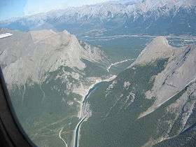
East End of Rundle (EEOR) is a mountain located immediately south of the town of Canmore Alberta just west of the Spray Lakes road in the Canadian Rockies. Mount Rundle occupies the space between Canmore and Banff on the south side of the Trans Canada Highway.
There is a scrambling route up from the Spray Lakes road.
External links
- Scramble description from www.scrambling.ca
- EEOR from www.peakware.com
- East End Rundle Trail from HikeAlberta.com
This article is issued from Wikipedia - version of the 12/24/2012. The text is available under the Creative Commons Attribution/Share Alike but additional terms may apply for the media files.