Waterton Park
| Waterton Park | |
|---|---|
| Hamlet | |
|
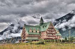
One of Canada's grand railway hotels the Prince of Wales Hotel a National Historic Site of Canada located at the east entrance of the Park. | |
 Location of Waterton Park in Alberta | |
| Coordinates: 49°03′06″N 113°54′51″W / 49.0517°N 113.9142°WCoordinates: 49°03′06″N 113°54′51″W / 49.0517°N 113.9142°W | |
| Country |
|
| Province |
|
| Census division | No. 3 |
| Improvement District | Improvement District No. 4 Waterton |
| Government | |
| • Type | Unincorporated |
| • Governing body | Alberta Municipal Affairs |
| Area[1] | |
| • Total | 480.58 km2 (185.55 sq mi) |
| Elevation | 1,280 m (4,200 ft) |
| Population (2011)[1] | |
| • Total | 88 |
| • Density | 0.18/km2 (0.47/sq mi) |
| • Dwellings | 181 |
| Time zone | MST (UTC-7) |
| Area code(s) | 403 / 587 |
| highways |
|
Waterton Park, commonly referred to as Waterton, is a hamlet in southwestern Alberta, Canada within Improvement District No. 4 Waterton (Waterton Lakes National Park).[2]
It is located at the southwestern terminus of Highway 5, approximately 54 kilometres (34 mi) west of the Town of Cardston and 55 kilometres (34 mi) south of the Town of Pincher Creek. This hamlet is north of Glacier National Park in Montana. It has an elevation of 1,280 metres (4,200 ft).
The hamlet is located in census division No. 3 and in the federal riding of Lethbridge.
Demographics
As a designated place in the 2011 Census, Waterton Park had a population of 88 living in 31 of its 181 total dwellings, a -45% change from its 2006 population of 160. With a land area of 480.58 km2 (185.55 sq mi), it had a population density of 0.1831/km2 (0.4743/sq mi) in 2011.[1]
As of 2006, Waterton Park had a total population of 160 living in 54 dwellings. With a land area of 480.58 km2 (185.55 sq mi), it had a population density of 0.3/km2 (0.78/sq mi).[3]
Climate
| Climate data for Waterton Park | |||||||||||||
|---|---|---|---|---|---|---|---|---|---|---|---|---|---|
| Month | Jan | Feb | Mar | Apr | May | Jun | Jul | Aug | Sep | Oct | Nov | Dec | Year |
| Record high °C (°F) | 15 (59) |
17 (63) |
20 (68) |
26.5 (79.7) |
30 (86) |
31 (88) |
34.5 (94.1) |
34 (93) |
32.8 (91) |
29 (84) |
19 (66) |
20 (68) |
34.5 (94.1) |
| Average high °C (°F) | 0.3 (32.5) |
1.3 (34.3) |
5.3 (41.5) |
10 (50) |
15 (59) |
19 (66) |
22.5 (72.5) |
22 (72) |
17.3 (63.1) |
11.8 (53.2) |
3.1 (37.6) |
−0.3 (31.5) |
10.6 (51.1) |
| Average low °C (°F) | −10.6 (12.9) |
−9.8 (14.4) |
−5.5 (22.1) |
−1.5 (29.3) |
2.8 (37) |
6.1 (43) |
7.9 (46.2) |
6.9 (44.4) |
3.4 (38.1) |
0.6 (33.1) |
−5.8 (21.6) |
−9.7 (14.5) |
−1.3 (29.7) |
| Record low °C (°F) | −40.5 (−40.9) |
−50 (−58) |
−34.4 (−29.9) |
−24.4 (−11.9) |
−11 (12) |
−6 (21) |
−3 (27) |
−5 (23) |
−12 (10) |
−27 (−17) |
−34 (−29) |
−44.5 (−48.1) |
−50 (−58) |
| Average precipitation mm (inches) | 59.3 (2.335) |
46.3 (1.823) |
69.3 (2.728) |
64.5 (2.539) |
94.5 (3.72) |
80.8 (3.181) |
70.8 (2.787) |
69 (2.72) |
60.8 (2.394) |
65.1 (2.563) |
68.7 (2.705) |
58.4 (2.299) |
807.6 (31.795) |
| Source: Environment Canada[4] | |||||||||||||
See also
References
- 1 2 3 "Population and dwelling counts, for Canada, provinces and territories, and designated places, 2011 and 2006 censuses (Alberta)". Statistics Canada. 2012-02-08. Retrieved 2012-04-07.
- ↑ Alberta Municipal Affairs (2010-04-01). "Specialized and Rural Municipalities and Their Communities" (PDF). Retrieved 2010-06-27.
- ↑ Statistics Canada (2007). "Population and dwelling counts, for Canada, provinces and territories, and designated places, 2006 and 2001 censuses". Retrieved 2010-02-06.
- ↑ Environment Canada—Canadian Climate Normals 1971–2000, accessed 23 March 2010