Dras River
| Dras River/ دراس ندی | |
| River | |
 Dras River | |
| Country | India |
|---|---|
| State | Jammu and Kashmir |
| Region | Ladakh |
| District | Kargil |
| Source | 34°16′20″N 75°31′47″E / 34.272303°N 75.529832°ECoordinates: 34°16′20″N 75°31′47″E / 34.272303°N 75.529832°E |
| - location | Machoi Glacier near Zojila |
| - elevation | 4,400 m (14,436 ft) |
| Mouth | 34°35′34″N 76°07′20″E / 34.592685°N 76.122271°E |
| - location | Suru River at Kharul Kargil |
| - elevation | 3,618 m (11,870 ft) |
| Length | 86 km (53 mi) |
| Discharge | |
| - average | 212 m3/s (7,487 cu ft/s) |
The Dras River, also spelt Drass River (Urdu: دراس ندی), is a river in the Kargil district of Ladakh region, in the Indian state of Jammu and Kashmir.
Geography
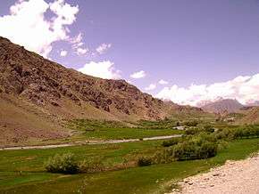
The Dras River is 86 km (53 mi) long and flows entirely in the Dras Valley. Its source lies in the Machoi Glacier near Zojila Pass, the gateway to Ladakh, 26 km (16 mi) east of Sonamarg and 120 km (75 mi) east of Srinagar, the capital of Jammu and Kashmir.[1][2] The Machoi Glacier is also the source of the Sind River, which flows through the neighbouring Kashmir Valley in the opposite direction to the Dras River.[3] The Dras River flows northeast, fed by many glacial streams. NH 1D, a national highway connecting Srinagar with Ladakh (Kargil and leh), runs parallel to the river. The river forms the Dras Valley at Dras,[2] where it is joined by two tributaries, the Mashko Nala and Gamru Nala, which originate in the glaciers of Mashko Valley.[3] In the Dras Valley, the road connecting Dras and Gurais runs parallel to the river.
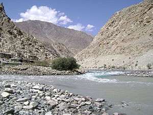
The Shingo River joins the Dras River at Kharbu, and doubles the flow of the river. The Shingo River is a confluent of the Marpo River and the Nakpo River, both of which originate in Pakistani-Administered Kashmir.[2][4] The Dras River joins the Suru River at Kharul, 7 km (4.3 mi) north of the town of Kargil.[2] The Suru River is a left tributary of the Indus River.[5] It originates from the Panzella glacier near Pensi La, flows northwards and merges with the Indus River at Nurla 5 km (3.1 mi) below its confluence with the Dras River, after entering Pakistani-Administered Kashmir at Post 43 and Post 44 of India and Pakistan respectively.[6]
The Dras River flows through the towns of Matayan, Kharbu and Kakshar. The largest settlement on its banks is Dras, which is the second coldest inhabited place in the world after Siberia.[7] The water flow of the river increases during the late summer, due to the heavy melting of glaciers.[8]
See also
References
| Wikimedia Commons has media related to Dras River. |
- ↑ "Kargil the Suru valley". gaffarkashmir.com. Retrieved 2012-08-29.
- 1 2 3 4 Omacanda Hāṇḍā (2001). Buddhist Western Himalaya: A politico-religious history. Indus Publishing, 2001. p. -67. ISBN 9788173871245. Retrieved 27 August 2012.
- 1 2 Harish Kapadia (1999). Across Peaks & Passes in Ladakh, Zanskar & East Karakoram. Indus Publishing, 1999. p. -226. ISBN 9788173871009. Retrieved 27 August 2012.
- ↑ William Moorcroft; George Trebeck; Horace Hayman Wilson (1841). Travels in the Himalayan Provinces of Hindustan and the Panjab; in Ladakh and Kashmir; in Peshawar, Kabul, Kunduz, and Bokhara ...: From 1819 to 1825, Volume 2. J. Murray, 1841. p. -261–265. Retrieved 27 August 2012.
- ↑ S. S. Negi (2002). Cold Deserts of India. Indus Publishing, 2002. p. -13. ISBN 9788173871276. Retrieved 27 August 2012.
- ↑ "Rivers of Ladakh". ladakh.com. Retrieved 2012-08-29.
- ↑ M.S. Kohli (2004). Mountains of India: Tourism, Adventure, Pilgrimage. Indus Publishing, 2004. p. -124. ISBN 9788173871351. Retrieved 29 August 2012.
- ↑ Sharad Singh Negi (1991). Himalayan Rivers, Lakes, and Glaciers Informative books on the himalayas-forestry-environment. Indus Publishing, 1991. p. -61. ISBN 9788185182612. Retrieved 27 August 2012.