Derby, Indiana
| Derby, Indiana | |
|---|---|
| Unincorporated community | |
|
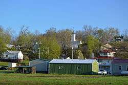
Overview from Mulzer Park | |
 Derby, Indiana  Derby, Indiana | |
| Coordinates: 38°1′49″N 86°31′38″W / 38.03028°N 86.52722°WCoordinates: 38°1′49″N 86°31′38″W / 38.03028°N 86.52722°W | |
| Country | United States |
| State | Indiana |
| County | Perry |
| Township | Union |
| Elevation | 449 ft (137 m) |
| ZIP code | 47525 |
| GNIS feature ID | 450842[1] |
Derby is an unincorporated community along the Ohio River in far southern Union Township, Perry County, Indiana, United States. It lies at the intersection of State Roads 66 and 70 above the city of Tell City, the county seat of Perry County.[2] Its elevation is 449 feet (137 m), and it is located at 38°1′49″N 86°31′38″W / 38.03028°N 86.52722°W (38.0303400, -86.5272018).[3] Although Derby is unincorporated, it has a post office, with the ZIP code of 47525.[4]
History
Derby was platted in 1835.[5] The community was named after Derby, in the United Kingdom.[6] A post office has been in operation at Derby since 1852.[7]
See also
References
- ↑ "Derby, Indiana". Geographic Names Information System. United States Geological Survey. Retrieved 2009-10-10.
- ↑ DeLorme. Indiana Atlas & Gazetteer. 3rd ed. Yarmouth: DeLorme, 2004, p. 62-63. ISBN 0-89933-319-2.
- ↑ Geographic Names Information System Feature Detail Report, Geographic Names Information System, 1979-02-14. Accessed 2008-06-01.
- ↑ Zip Code Lookup
- ↑ Hunt, Thomas James De la (1916). Perry County: A History. W.K. Stewart. p. 82.
- ↑ Baker, Ronald L. (October 1995). From Needmore to Prosperity: Hoosier Place Names in Folklore and History. Indiana University Press. p. 113. ISBN 978-0-253-32866-3.
...for Derby, Ireland, the home of his ancestors.
- ↑ "Perry County". Jim Forte Postal History. Retrieved 2 October 2015.
Municipalities and communities of Perry County, Indiana, United States | ||
|---|---|---|
| Cities | ||
| Town | ||
| Townships | ||
| Unincorporated communities |
| |
This article is issued from Wikipedia - version of the 10/10/2016. The text is available under the Creative Commons Attribution/Share Alike but additional terms may apply for the media files.