Delaware River Viaduct
| Delaware River Viaduct | |
|---|---|
 | |
| Carries | Lackawanna Cut-Off |
| Crosses | Delaware River, I-80 |
| Locale | Between Portland, PA and Columbia, NJ |
| Characteristics | |
| Material | Reinforced concrete |
| Total length | 1,452 feet (443 m) |
| Width | 34 feet (10 m) |
| Height | 65 feet (20 m) |
| Longest span | 150 feet (46 m) |
| Number of spans | 9 |
| Piers in water | 6 |
| History | |
| Designer | Abraham Burton Cohen |
| Construction begin | August 1908 |
| Construction end | December 1, 1910 |
| Opened | December 24, 1911 |
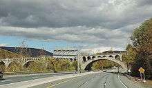
The Delaware River Viaduct is a reinforced concrete railroad bridge across the Delaware River about 2 miles (3.2 km) south of the Delaware Water Gap that was built in 1908-10 as part of the Lackawanna Cut-Off rail line. It is the sister to the line's larger Paulinskill Viaduct. The Delaware River Viaduct also crosses Interstate 80 on the east (New Jersey) side of the river and Slateford Road and the Lackawanna Railroad's "Old Road" (now Delaware-Lackawanna) on the west (Pennsylvania) side. Abandoned in 1983, it is part of a New Jersey Transit proposal to restore passenger service to Scranton, Pennsylvania.
The bridge is 1,452 feet (443 m) long and 65 feet (20 m) high from water level to the top of the rail, and is composed of five 150-foot (46 m) spans and two 120-foot (37 m) spans. The footings were excavated down to bedrock, which ranges from 26 feet (7.9 m) to 53 feet (16 m) below the surface.[1] A total of 51,376 cubic feet (1,454.8 m3) of concrete and 627 tons of reinforcing steel were used to construct this bridge.
Construction of the bridge was described in an article by Abraham Burton Cohen, then a draftsman for the Delaware, Lackawanna and Western Railroad, who went on to design the Tunkhannock Viaduct, an even larger structure on the railroad's Summit-Hallstead Cutoff.[2] The bridge was completed on December 1, 1910, about a year before the Cut-Off opened, which allowed construction trains to haul building materials to work sites east of the bridge.[3]
The bridge was originally envisioned as a curved bridge with a 1°30" curve that would have allowed speeds of 80 mph (129 km/hr).[4] But the design was altered to include a tangent (straight) stretch of track across the bridge, a 1°30" curve on the New Jersey side and a 3°30" curve on the Pennsylvania side of the bridge. This tighter curve required trains to slow to 50 mph (80 km/hr). No other curves on the 28-mile Cut-Off were sharper than 2°. Later, the super-elevation of this curve was increased, bumping up the speed limit to 55 miles per hour (89 km/h).
The viaduct is the largest reinforced concrete structure built with a continuous pour process. There is no known evidence to support the legend that several workers fell into the concrete during construction and could not be extracted because of the need to keep pouring.
The tracks were removed by Conrail in March 1989, five years later than the rest of the New Jersey section of the Cut-Off.
A proposal to restore train service between Andover, New Jersey, and Scranton would require substantial repairs to the bridge. (NJ Transit would be the designated operator for service in New Jersey, and most likely the one for service in Pennsylvania.) As of 2016, the Pennsylvania Northeast Railroad Authority (PNERRA) is gathering funding to commission a study to update the 2009 estimates of the costs of restoring service, including the bridge repairs.
See also
- List of bridges documented by the Historic American Engineering Record in Pennsylvania
- List of crossings of the Delaware River
References
- ↑ Cohen, A. B. "The Delaware River Viaduct." Purdue Engineering Review, No. 6 (1909-10): 13.
- ↑ Cohen, A. B. "The Delaware River Viaduct." Purdue Engineering Review, No. 6 (1909-10): 9-18.
- ↑ The Lackawanna Railroad in Northwest New Jersey, Larry Lowenthal and William T. Greenberg, Jr., Tri-State Railway Historical Society Inc. Publication, 1987, p. 74
- ↑ 1906 Survey Map of the Delaware Valley Cut-Off, September 1, 1906
External links
| Wikimedia Commons has media related to Delaware River Viaduct. |
- Historic American Engineering Record (HAER) No. PA-541, "Delaware River Viaduct"
- Touring the Lackawanna Cut-Off
Coordinates: 40°56′15″N 75°06′21″W / 40.9376°N 75.1057°W
| Bridges of the Delaware River | ||||
|---|---|---|---|---|
| ||||