Culemborg
| Culemborg | |||
|---|---|---|---|
| City and municipality | |||
|
Culemborg market square | |||
| |||
.svg.png) Location in Gelderland | |||
| Coordinates: 51°57′N 5°14′E / 51.950°N 5.233°ECoordinates: 51°57′N 5°14′E / 51.950°N 5.233°E | |||
| Country | Netherlands | ||
| Province | Gelderland | ||
| Government[1] | |||
| • Body | Municipal council | ||
| • Mayor | Roland van Schelven (D66) | ||
| Area[2] | |||
| • Total | 31.14 km2 (12.02 sq mi) | ||
| • Land | 29.42 km2 (11.36 sq mi) | ||
| • Water | 1.72 km2 (0.66 sq mi) | ||
| Elevation[3] | 5 m (16 ft) | ||
| Population (May 2014)[4] | |||
| • Total | 27,568 | ||
| • Density | 937/km2 (2,430/sq mi) | ||
| Demonym(s) | Culemborger | ||
| Time zone | CET (UTC+1) | ||
| • Summer (DST) | CEST (UTC+2) | ||
| Postcode | 4100–4107 | ||
| Area code | 0345 | ||
| Website |
www | ||
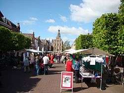


Culemborg (Dutch pronunciation: [ˈkyləmbɔrx]; formerly also spelled Kuilenburg or Kuylenburgh) is a municipality and a city in the centre of the Netherlands. The city is situated just south of the Lek River. The cities of Utrecht and 's-Hertogenbosch can be reached easily by train.
History

It received city rights in 1318.
In Joan Blaeu's map of 1649, Culemborg remains entirely enclosed by walls behind its city moat-like encircling canals. The moated castle stands outside the city walls. Houses present a united front along streets and the two canals that cut the city in three sections, but they all face gardens behind, and market gardens are plentiful within the city walls.
In 1995, Culemborg was one of the cities which was temporarily evacuated because of the risk of flooding.
Transportation
Culemborg is served by Culemborg railway station, which offers trains to Utrecht (city) 4x per hour and 2x per hour to Breda and Tiel each. The railway station also provides a bus hub, offering buses to the various neighbouring cities and villages (namely Buren, Beusichem and Nieuwegein).
Topography

Dutch topographic map of the municipality of Culemborg, June 2015
Industry
Dough processing company Rademaker BV, founded in 1977, moved to Culemborg in 1981 and still has their headquarters here.
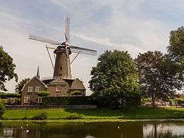
Windmills
There are two traditional windmills in Culemborg, De Hoop and Johanna. The base of a third mill, De Koornvriend, also survives.[5]
Notable residents
- Anthony van Diemen (1593–1645), Governor-General of the Dutch East Indies
- Jan van Riebeeck (1619–1677), colonial administrator and founder of Cape Town (South Africa)
- Roelof de Man (1634 - 1663), bookkeeper and second-in-charge to Jan van Riebeeck at founding of Cape Town (South Africa)
- Otto van Rees (1823–1892), minister and Governor-General of the Dutch East Indies
- Wilhelmina Cooper (May 1, 1939 – March 1, 1980), fashion model and founder of Wilhelmina Models, New York
- Rudi Martinus van Dijk (1932–2003), classical composer
- Elly van Hulst (born 1959), middle distance runner
- Arjan Vermeulen (born 1969), football player
- Patrick Pothuizen (born 1972), football player
- Jelka van Houten (born 1978), actress
- Michiel Elijzen (born 1982), bicycle racer
References
- ↑ "Burgemeester Van Schelven" [Mayor Van Schelven] (in Dutch). Gemeente Culemborg. Retrieved 23 June 2014.
- ↑ "Kerncijfers wijken en buurten" [Key figures for neighbourhoods]. CBS Statline (in Dutch). CBS. 2 July 2013. Retrieved 12 March 2014.
- ↑ "Postcodetool for 4101BK". Actueel Hoogtebestand Nederland (in Dutch). Het Waterschapshuis. Retrieved 23 June 2014.
- ↑ "Bevolkingsontwikkeling; regio per maand" [Population growth; regions per month]. CBS Statline (in Dutch). CBS. 26 June 2014. Retrieved 24 July 2014.
- ↑ "De Koornvriend, Culemborg" (in Dutch). Molendatabase. Retrieved 6 November 2014.
External links
 Media related to Culemborg at Wikimedia Commons
- (Dutch) Official website
 |
Houten (UT) Lek |
Wijk bij Duurstede (UT) Lek |
| |
| Vianen (UT) | |
Buren | ||
| ||||
| | ||||
| Leerdam (ZH) | Geldermalsen |
