Tiel
| Tiel | |||
|---|---|---|---|
| Municipality | |||
|
Fortified dyke in Tiel | |||
| |||
.svg.png) Location in Gelderland | |||
| Coordinates: 51°53′N 5°26′E / 51.883°N 5.433°ECoordinates: 51°53′N 5°26′E / 51.883°N 5.433°E | |||
| Country | Netherlands | ||
| Province | Gelderland | ||
| Government[1] | |||
| • Body | Municipal council | ||
| • Mayor | Hans Beenakker (VVD) | ||
| Area[2] | |||
| • Total | 34.81 km2 (13.44 sq mi) | ||
| • Land | 32.27 km2 (12.46 sq mi) | ||
| • Water | 2.54 km2 (0.98 sq mi) | ||
| Elevation[3] | 7 m (23 ft) | ||
| Population (May 2014)[4] | |||
| • Total | 41,723 | ||
| • Density | 1,293/km2 (3,350/sq mi) | ||
| Demonym(s) | Tielenaar | ||
| Time zone | CET (UTC+1) | ||
| • Summer (DST) | CEST (UTC+2) | ||
| Postcode | 4000–4007, 4013–4014, 4017, 4062 | ||
| Area code | 0344 | ||
| Website |
www | ||


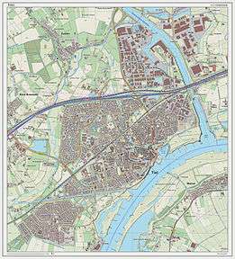
Tiel (Dutch pronunciation: [til]) is a municipality and a town in the middle of the Netherlands. The town is enclosed by the Waal river and the Linge river on the south and the north side, and the Amsterdam-Rhine Canal on the east side. The city was founded in the 5th century AD.
Population centres
- Kapel-Avezaath
- Tiel
- Wadenoijen
The town of Tiel
Tiel is the largest town in the Betuwe area, which is famous for being one of the centres of Dutch fruit production. Orchards in the area produce apples, pears, plums and cherries. Tiel once housed the famous jam factory De Betuwe. After production was moved to Breda in 1993, the entire complex was demolished, although a part was reconstructed later. Reminding of this industry is a jam manufacturing museum and a statue of Flipje, the raspberry-based comic figure who starred in De Betuwe's, jam factory advertisements since the 1930s.
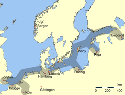
Tiel is one of the oldest towns in the Netherlands. Originally located on the Linge river it became an important centre of trade in the early Middle Ages, especially after the demise of Dorestad in the 9th century. Later in the Middle Ages Tiel was associated with the Hanseatic League. At the height of its glory Tiel had two big churches, one of which, the St. Walburg, was a collegiate church that belonged to the Teutonic Knights and vanished after the Reformation while the other church, the St. Maarten, became Protestant. Much of the historic centre was destroyed during the Second World War.
Every year, on the third Saturday in September, a festival known as 'Fruitcorso' is held to celebrate the fruit harvest from the Betuwe area. On this day, a parade of wagons, decorated with fruit, travels through the city, competing for the top three ranking. This top three is split in a 'normal' and a 'youth' category, with the wagons in the youth category featuring smaller wagons. Along the canal fruit mosaics are made by various organisations, also competing for a place in the top three. In the past, this event was accompanied by 'Appelpop', a free, two-day music event on the Waalkade. Due to Appelpop's popularity, Fruitcorso and Appelpop were split up, with Appelpop taking the second Friday and Saturday of September.
Tiel has also been known for its pewter industry. The last pewter factory cum museum, which mainly produced collectibles for tourists, went bankrupt in early 2004, but has since been revived. Tiel can be a good starting point to explore the rest of the scenic Betuwe area, particularly in May when all the fruit trees in the surrounding areas are in bloom.
The Dutch author and polemicist Menno ter Braak (1902–1940) grew up in Tiel.
 Statue of "Flipje" in Tiel
 Tiel, church: Sint Maartenskerk
 Tiel, Appelpop on the Waalkade
 Jewish Monument, Tiel
Demographics
Residents as of 2010:[5]
- 78.4% both parents born in the Netherlands.
- 8.2% other European
- 13.4% non-European, including:
- 5.2% Turkish
- 4.3% Moroccan
- 0.6% Surinamese
- 0.5% Netherlands Antilles and Aruba
- 2.7% Others.
Notable residents
- Joan van der Capellen tot den Pol (1741–1784), statesman
- David Hendrik Chassé (1765–1849), soldier
- William Hendriksen (1900–1982), New Testament scholar
- Mary Dresselhuys (1907–2004), stage actress
- Herman Claudius van Riemsdijk (b. 1948), chess player
- Jan van Deinsen (born 1953), football player
- Corrie van Binsbergen (born 1957), musician
- Anton Janssen (born 1963), football player
- Wilma van Velsen (born 1964), swimmer
- Dirk Jan Derksen (born 1972), football player
- Frans Duijts (born 1979), singer
- Bobbie Traksel (born 1981), cyclist
- Erik Pieters (born 1988), football player
- Barry Maguire (born 1989), football player
References
- ↑ "Burgemeester en wethouders" [Mayor and aldermen] (in Dutch). Gemeente Tiel. Retrieved 16 June 2014.
- ↑ "Kerncijfers wijken en buurten" [Key figures for neighbourhoods]. CBS Statline (in Dutch). CBS. 2 July 2013. Retrieved 12 March 2014.
- ↑ "Postcodetool for 4001MV". Actueel Hoogtebestand Nederland (in Dutch). Het Waterschapshuis. Retrieved 16 June 2014.
- ↑ "Bevolkingsontwikkeling; regio per maand" [Population growth; regions per month]. CBS Statline (in Dutch). CBS. 26 June 2014. Retrieved 24 July 2014.
- ↑ "Niet-westerse allochtonen per gemeente 2010-2040 - Nationale Atlas Volksgezondheid". Zorgatlas.nl. 2010-12-03. Retrieved 2012-03-28.
External links
 Media related to Tiel at Wikimedia Commons
 Tiel travel guide from Wikivoyage
- Official website
 |
Buren | | ||
| Geldermalsen | |
Neder-Betuwe | ||
| ||||
| | ||||
| Neerijnen | |
Waal / West Maas en Waal |
Members of the Hanseatic League by Quarter | |||||||
|---|---|---|---|---|---|---|---|
| |||||||
| Wendish |
|  | |||||
| Saxon | |||||||
| Baltic | |||||||
| Westphalian | |||||||
| Kontore |
| ||||||
| Other cities | |||||||
