County of Wonnangatta
| Wonnangatta Victoria | |||||||||||||
|---|---|---|---|---|---|---|---|---|---|---|---|---|---|
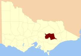 Location in Victoria | |||||||||||||
| Established | 24 February 1871 | ||||||||||||
| Area | 5,760 km2 (2,223.9 sq mi) | ||||||||||||
| |||||||||||||
The County of Wonnangatta is one of the 37 counties of Victoria which are part of the cadastral divisions of Australia, used for land titles. It includes the western parts of the Alpine National Park. The Wonnangatta River is located in the east of the county. Lake Eildon is at the northwestern edge. Mount Buller is on the northern edge.
Parishes
Parishes include:
- Billabong, Victoria
- Bolaira, Victoria
- Boorolite, Victoria
- Buckenderra, Victoria
- Budgee Budgee, Victoria
- Buragwonduc, Victoria
- Changue, Victoria
- Cobbannah, Victoria
- Crookayan, Victoria
- Darlingford, Victoria
- Doledrook, Victoria
- Enoch's Point, Victoria
- Goulburn, Victoria
- Howqua, Victoria
- Howqua West, Victoria
- Jamieson, Victoria
- Kevington, Victoria
- Knockwood, Victoria
- Kybeyan, Victoria
- Lauraville, Victoria
- Licola, Victoria
- Lodge Park, Victoria
- Matlock, Victoria
- Miowera, Victoria
- Moroka, Victoria
- Narbourac, Victoria
- St.Clair, Victoria
- Tamboritha, Victoria
- Taponga, Victoria
- Tarldarn, Victoria
- Torbreck, Victoria
- Warrambat, Victoria
- Wonnangatta, Victoria
- Youarrabuk, Victoria
References
- Vicnames, place name details
- Research aids, Victoria 1910
- Map of the Wonnangatta region in Victoria showing county boundaries, parishes, available agricultural and grazing land, available pastoral land, available land to be sold at auction and timber reserves 1893, Dept. of Lands and Survey. held at the National Library of Australia
Coordinates: 37°25′S 146°30′E / 37.417°S 146.500°E
This article is issued from Wikipedia - version of the 10/29/2013. The text is available under the Creative Commons Attribution/Share Alike but additional terms may apply for the media files.