Mount Buller, Victoria
| Mount Buller Village Victoria | |||||||
|---|---|---|---|---|---|---|---|
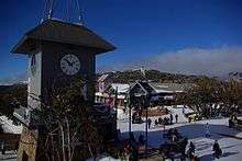
 Bourke St, the main series of lifts leading from the village towards the summit of Mount Buller | |||||||
 Mount Buller Village | |||||||
| Coordinates | 37°08′S 146°25′E / 37.133°S 146.417°ECoordinates: 37°08′S 146°25′E / 37.133°S 146.417°E | ||||||
| Population | 242 (2011 census)[1] | ||||||
| Postcode(s) | 3723 | ||||||
| Location | |||||||
| LGA(s) | Shire of Mansfield | ||||||
| State electorate(s) | Eildon | ||||||
| Federal Division(s) | Indi | ||||||
| |||||||
Mount Buller is a town located in the Shire of Mansfield in the Alpine region of the Australian state of Victoria. The town is located approximately 208 kilometres (129 mi) east of Melbourne on the slopes of Mount Buller.[2]
Primarily a resort town, Mount Buller is popular with snowsports enthusiasts in winter due to its close location to Melbourne. At the 2011 census, Mount Buller had a population of 242.[1]
The Mount Buller Alpine Resort is an unincorporated area of Victoria; the larger surrounding locality of Mount Buller is part of the Shire of Mansfield.
Mount Buller village
The town has around 7000 beds available in accommodation facilities, the most of any Victorian ski resort. La Trobe University had a minor campus at Mount Buller. The campus facilities included a public cinema, gym and indoor sporting facilities. La Trobe has vacated the mountain, however the Resort Management Board is now using the building, better known as the Mount Buller Community Centre, as its home. All facilities are still operational, with the cinema, gym and sports hall open all year round. Mount Buller is also the home of the National Alpine Museum.
The area between Mount Buller and Mount Stirling is the primary catchment for the Delatite River.
Sports and recreation
Mountain biking
Mount Buller is home to a growing number of first class Cross Country and Downhill mountain bike tracks. Between 2009 and 2012 many trails have been added, modified and upgraded by WORLD TRAIL. The chairlift for the downhill tracks is only open during the summer from Boxing Day until the end of January, although trailer shuttles also run until the end of February. Mt Buller is working towards developing the mountain as a world class mountain bike venue in line with what has been achieved at Whistler (Canada) and Queenstown (New Zealand). Retail outlets exist in the mountain village to enable casual riders to hire pushbikes, and for bike owners to access service should the need arise. The Victorian Downhill State Series holds a race each year at Mt Buller, as does the MTBA National Series.
The International Mountain Bicycling Association has designated the mountain biking trails at Mount Buller as a bronze-level IMBA Ride Center.[3] Ride Centers are the IMBA's strongest endorsement of a trail experience.[4]
Road cycling
Mount Buller is also a popular destination for road cyclists,[5] due to the challenging climb from the tollbooth in Mirimbah to the Mount Buller Village. The climb is 15.3 kilometres (9.5 mi) long and has an average gradient of 6.2%.[6] The final kilometre before the Village is the steepest part of the climb with several short sections of gradient 10%+.
Skiing, snowboarding, and hiking
Comprising 300 hectares (740 acres), the Mount Buller Alpine Resort is a year-round facility with peak operation during winter months for alpine sports. In the summer months, the area is a popular location for alpine hiking.
Geography
Climate
Mount Buller has a climatic transitional zone between a continental climate (Köppen Dfb/Dfc), and an oceanic climate (Köppen Cfb/Cfc), depending on the isotherm used, with mild summers and snowy but not severely cold winters.
| Climate data for Mount Buller | |||||||||||||
|---|---|---|---|---|---|---|---|---|---|---|---|---|---|
| Month | Jan | Feb | Mar | Apr | May | Jun | Jul | Aug | Sep | Oct | Nov | Dec | Year |
| Record high °C (°F) | 30.3 (86.5) |
30.7 (87.3) |
25.3 (77.5) |
21.6 (70.9) |
16.5 (61.7) |
12.7 (54.9) |
15.3 (59.5) |
10.8 (51.4) |
16.7 (62.1) |
21.6 (70.9) |
26.1 (79) |
27.3 (81.1) |
30.7 (87.3) |
| Average high °C (°F) | 17.3 (63.1) |
17.0 (62.6) |
14.1 (57.4) |
9.8 (49.6) |
6.3 (43.3) |
3.2 (37.8) |
1.4 (34.5) |
2.1 (35.8) |
4.8 (40.6) |
8.4 (47.1) |
12.4 (54.3) |
14.4 (57.9) |
9.3 (48.7) |
| Average low °C (°F) | 8.8 (47.8) |
8.9 (48) |
6.6 (43.9) |
3.6 (38.5) |
1.0 (33.8) |
−1.2 (29.8) |
−2.7 (27.1) |
−2.4 (27.7) |
−0.8 (30.6) |
1.2 (34.2) |
4.8 (40.6) |
6.0 (42.8) |
2.8 (37) |
| Record low °C (°F) | −3.5 (25.7) |
−2.6 (27.3) |
−4.5 (23.9) |
−6.9 (19.6) |
−6.9 (19.6) |
−9.1 (15.6) |
−10.2 (13.6) |
−11.4 (11.5) |
−8.4 (16.9) |
−7.6 (18.3) |
−5.5 (22.1) |
−6.2 (20.8) |
−11.4 (11.5) |
| Average precipitation mm (inches) | 72.6 (2.858) |
77.4 (3.047) |
80.1 (3.154) |
105.1 (4.138) |
133.0 (5.236) |
147.1 (5.791) |
162.4 (6.394) |
156.3 (6.154) |
149.4 (5.882) |
143.2 (5.638) |
126.2 (4.969) |
97.4 (3.835) |
1,352.8 (53.26) |
| Average precipitation days | 7.1 | 6.9 | 8.1 | 10.3 | 13.0 | 14.4 | 15.8 | 15.8 | 14.2 | 14.3 | 10.8 | 9.2 | 139.9 |
| Average relative humidity (%) | 66 | 66 | 69 | 79 | 85 | 89 | 90 | 91 | 87 | 78 | 71 | 68 | 78 |
| Source: [7] | |||||||||||||
References
| Wikimedia Commons has media related to Mount Buller. |
- 1 2 Australian Bureau of Statistics (31 October 2012). "Mount Buller (State Suburb)". 2011 Census QuickStats. Retrieved 1 December 2014.
- ↑ Place names search, Geoscience Australia
- ↑ http://www.imba.com/mt-buller-victoria-australia-bronze-level
- ↑ http://www.richmond.com/recreation/article_32482592-e8ba-11e2-83fb-0019bb30f31a.html
- ↑ http://theclimbingcyclist.com/climbs/alpine-national-park/mt-buller/
- ↑ http://app.strava.com/segments/631265
- ↑ "Climate statistics for Mount Buller". Australian Bureau of Meteorology. Retrieved 24 June 2014.