Control and Reporting Centre
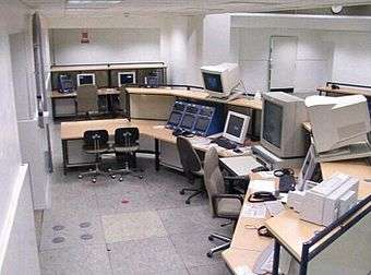
Control and Reporting Centre (sort: CRC) is according to the Joint Chiefs of Staff publication 1.02 defined as – «A subordinated air control element of the tactical air control centre for which radar control and warning operations are conducted within its area of responsibility[1]».
Control and reporting posts (CRP)/ reporting posts (RP), which provide radar control and surveillance within their defined areas of responsibility, normally may be subordinated.
NATO operates ACC Systems in static or deployable CRC's in order to provide Airspace Surveillance, to control Air Force Operations and to meet national and allied military commitments. In NATO Europe a CRC might be subordinated to a Combined Air Operations Centre (CAOC) and / or to an equivalent national Air Operation Centre.
CRC in NATO Europe
| Designation | Location | Remark | |||
|---|---|---|---|---|---|
| CAOC UD | D Uedem | 51°40'50"N 6°18'20"E | Responsible for NATO airspace north of the Alps | ||
| CAOC TJ | E Torrejon | 40°30'12"N 3°27'25"W | Responsible for NATO airspace south of the Alps | ||
| DACCC PR | I Poggio Renatico | 44°47'30"N 11°29'50"E | Homebase of NATO WW deployable Air C2 Center | ||
| CRC | B Glons | 50°44'24"N 5°32'35"E | national air ops | ||
| CRC | CZ Hlavenec | 50°12'28"N 14°41'22"E | national air ops | ||
| CRC | DK Finderup | 56°25'50"N 9°14'50"E | national air ops | ||
| CRC | F Cinq Mars la Pile | 47°21'6"N 0°27'47"E | national air ops | ||
| CRC | F Loperhet | 48°24'10"N 4°18'54"W | national air ops | ||
| CRC | F Lyon Mt.Verdun | 45°51'10"N 4°47'1"E | national air ops | ||
| CRC | F Mont de Marsan | 43°55'20"N 0°29'42"W | national air ops | ||
| CRC | D Erndtebrück | 50°59'36"N 8°14'25"E | national air ops | ||
| CRC | D Schönewalde | 51°48'38"N 13°11'26"E | national air ops | ||
| CRC | GR Larissa | 39°37'47"N 22°24'18"E | national air ops | ||
| CRC | I Licola | 40°53'31"N 14° 2'27"E | national air ops | ||
| ARS | I Poggio Renatico | national air ops | |||
| CRC | NL Nieuw Milligen | 52°13'22"N 5°45'1"E | national air ops | ||
| CRC | N Mågerø | 59° 9'18"N 10°26'23"E | national air ops | ||
| CRC | N Sørreisa | 69°3'36"N 17°59'57"E | national air ops | ||
| CRC | TR Eskesehir | 39°24'51"N 29°51'27"E | national air ops | ||
| CRC | UK Boulmer | 55°24'28"N 1°37'17"W | national air ops | ||
External links
References
- ↑ Chiefs of Staff publication 1.02, NATO, definition: Control and Reporting Centre (CRC).
- MILITÄRISCHES STUDIENGLOSAR ENGLISCH Teil I, A – K, Bundessprachenamt (Stand Januar 2001), page 355, definition: control and reporting center [CRC].
Coordinates: 51°47′06″N 13°10′33″E / 51.7850°N 13.1759°E