Schönewalde
| Schönewalde | |
|---|---|
 Schönewalde | |
Location of Schönewalde within Elbe-Elster district  | |
| Coordinates: 51°48′45″N 13°13′22″E / 51.81250°N 13.22278°ECoordinates: 51°48′45″N 13°13′22″E / 51.81250°N 13.22278°E | |
| Country | Germany |
| State | Brandenburg |
| District | Elbe-Elster |
| Government | |
| • Mayor | Irene Kluge |
| Area | |
| • Total | 155.13 km2 (59.90 sq mi) |
| Population (2015-12-31)[1] | |
| • Total | 3,115 |
| • Density | 20/km2 (52/sq mi) |
| Time zone | CET/CEST (UTC+1/+2) |
| Postal codes | 04916 |
| Dialling codes | 035362 |
| Vehicle registration | EE |
| Website | www.schoenewalde.de |
Schönewalde is a town in the Elbe-Elster district, in southwestern Brandenburg, Germany. It is situated 30 km south of Luckenwalde, and 40 km east of Wittenberg.
Demography
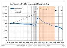
Development of Population since 1875 within the Current Boundaries (Blue Line: Population; Dotted Line: Comparison to Population Development of Brandenburg state; Grey Background: Time of Nazi rule; Red Background: Time of Communist rule)
|
|
|
|
Detailed data sources are to be found in the Wikimedia Commons.[3]
References
- ↑ "Bevölkerung im Land Brandenburg nach amtsfreien Gemeinden, Ämtern und Gemeinden 31. Dezember 2015 (Fortgeschriebene amtliche Einwohnerzahlen auf Grundlage des Zensus 2011)". Amt für Statistik Berlin-Brandenburg (in German). 2016.
- ↑ Boundaries as of 2013
- ↑ Population Projection Brandenburg at Wikimedia Commons
This article is issued from Wikipedia - version of the 7/17/2015. The text is available under the Creative Commons Attribution/Share Alike but additional terms may apply for the media files.