Sørreisa
| Sørreisa kommune Ráisavuona suohkan | |||
|---|---|---|---|
| Municipality | |||
| |||
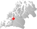 Sørreisa within Troms | |||
| Coordinates: 69°5′31″N 18°11′37″E / 69.09194°N 18.19361°ECoordinates: 69°5′31″N 18°11′37″E / 69.09194°N 18.19361°E | |||
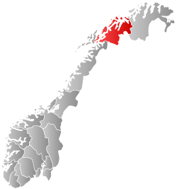
| Country | Norway | ||
| County | Troms | ||
| District | Midt-Troms | ||
| Administrative centre | Sørreisa | ||
| Government | |||
| • Mayor (2011) | Paul Dahlø (Ap) | ||
| Area | |||
| • Total | 362.95 km2 (140.14 sq mi) | ||
| • Land | 346.94 km2 (133.95 sq mi) | ||
| • Water | 16.01 km2 (6.18 sq mi) | ||
| Area rank | 253 in Norway | ||
| Population (2012) | |||
| • Total | 3,381 | ||
| • Rank | 252 in Norway | ||
| • Density | 9.7/km2 (25/sq mi) | ||
| • Change (10 years) | 2.5 % | ||
| Demonym(s) | Sørreisværing[1] | ||
| Time zone | CET (UTC+1) | ||
| • Summer (DST) | CEST (UTC+2) | ||
| ISO 3166 code | NO-1925 | ||
| Official language form | Neutral | ||
| Website |
www | ||
|
| |||

Sørreisa (Northern Sami: Ráisavuona suohkan) is a municipality in Troms county, Norway. The administrative centre of the municipality is the village of Sørreisa. Other villages include Grunnreisa, Skøelva, and Smørsgård.
General information
The municipality of Sørreisen was established on 1 September 1886 when it was separated from the municipality of Tranøy. The initial population of Sørreisen was 1,361. Later the spelling was changed to Sørreisa. On 1 January 1964, the part of Sørreisa across the Reisafjorden on the island of Senja (population: 129) was transferred to the municipality of Lenvik.[2]
Name
The municipality is named after the Reisafjorden (originally Reisa), which again is named after the Reisaelva (the "Reisa river" - originally Reisa). The river name is derived from the verb rísa which means "raise" (referring to flooding). The first element Sør ("south") was added to distinguish the municipality from Nordreisa. The municipality was originally named Sørreisen.[3]
Coat-of-arms
The coat-of-arms is from modern times. They were granted on 7 September 1984. The arms show three gold stars on a red background. It was derived from the oldest known seal in the municipality, a 17th-century seal of Jacob Hansen Kinapel, who was a police sergeant in Sørreisa from 1715 to 1748.[4]
Churches
The Church of Norway has one parish (sokn) within the municipality of Sørreisa. It is part of the Indre Troms deanery in the Diocese of Nord-Hålogaland.
| Parish (Sokn) | Church Name | Location of the Church | Year Built |
|---|---|---|---|
| Sørreisa | Sørreisa Church | Tømmervika | 1992 |
| Skøelv Chapel | Skøelva | 1966 | |
| Straumen Chapel | Sørreisa | 1973 |
Geography
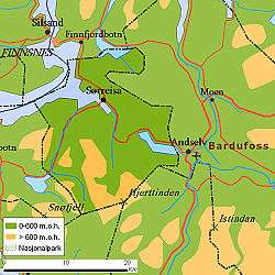
Sørreisa is located on the western coast of Norway, along the Reisafjorden, just east of the large island of Senja. The 363-square-kilometre (140 sq mi) municipality is mostly populated along the shoreline. The municipality of Dyrøy lies to the west, Salangen and Bardu to the south, Målselv to the east, and Lenvik to the north.
Climate
| Climate data for Sørreisa | |||||||||||||
|---|---|---|---|---|---|---|---|---|---|---|---|---|---|
| Month | Jan | Feb | Mar | Apr | May | Jun | Jul | Aug | Sep | Oct | Nov | Dec | Year |
| Daily mean °C (°F) | −4.5 (23.9) |
−4.3 (24.3) |
−2.3 (27.9) |
1.0 (33.8) |
5.9 (42.6) |
10.2 (50.4) |
12.7 (54.9) |
11.5 (52.7) |
7.4 (45.3) |
3.4 (38.1) |
−0.8 (30.6) |
−3.1 (26.4) |
3.1 (37.6) |
| Average precipitation mm (inches) | 97 (3.82) |
86 (3.39) |
67 (2.64) |
56 (2.2) |
39 (1.54) |
50 (1.97) |
66 (2.6) |
74 (2.91) |
92 (3.62) |
122 (4.8) |
103 (4.06) |
103 (4.06) |
955 (37.6) |
| Source: Norwegian Meteorological Institute[5] | |||||||||||||
Government
All municipalities in Norway, including Sørreisa, are responsible for primary education (through 10th grade), outpatient health services, senior citizen services, unemployment and other social services, zoning, economic development, and municipal roads. The municipality is governed by a municipal council of elected representatives, which in turn elect a mayor.
Municipal council
The municipal council (Kommunestyre) of Sørreisa is made up of 15 representatives that are elected to every four years. Currently, the party breakdown is as follows:[6]
| Party Name | Name in Norwegian | Number of representatives | |
|---|---|---|---|
| Labour Party | Arbeiderpartiet | 7 | |
| Progress Party | Fremskrittspartiet | 1 | |
| Conservative Party | Høyre | 2 | |
| Centre Party | Senterpartiet | 1 | |
| Local Lists | Lokale lister | 4 | |
| Total number of members: | 15 | ||
References
- ↑ "Navn på steder og personer: Innbyggjarnamn" (in Norwegian). Språkrådet. Retrieved 2015-12-01.
- ↑ Jukvam, Dag (1999). "Historisk oversikt over endringer i kommune- og fylkesinndelingen" (PDF) (in Norwegian). Statistisk sentralbyrå.
- ↑ Rygh, Oluf (1911). Norske gaardnavne: Troms amt (in Norwegian) (17 ed.). Kristiania, Norge: W. C. Fabritius & sønners bogtrikkeri. p. 62.
- ↑ Norske Kommunevåpen (1990). "Nye kommunevåbener i Norden". Retrieved 2008-12-07.
- ↑ "eKlima Web Portal". Norwegian Meteorological Institute.
- ↑ "Table: 04813: Members of the local councils, by party/electoral list at the Municipal Council election (M)" (in Norwegian). Statistics Norway. 2015.
External links
-
 Media related to Sørreisa at Wikimedia Commons
 -
 The dictionary definition of sørreisa at Wiktionary
 -
 Troms travel guide from Wikivoyage
 - Municipal fact sheet from Statistics Norway