Conowingo Dam
| Conowingo Dam | |
|---|---|
 Conowingo Dam, looking North | |
 Location of Conowingo Dam in Maryland | |
| Official name | Conowingo Hydroelectric Station |
| Country | United States |
| Location | Cecil and Harford counties, Maryland |
| Coordinates | 39°39′36″N 76°10′26″W / 39.66000°N 76.17389°WCoordinates: 39°39′36″N 76°10′26″W / 39.66000°N 76.17389°W |
| Status | Operational |
| Construction began | 1926 (completed in 1928) |
| Opening date | 1929 |
| Owner(s) | Susquehanna Electric Company |
| Dam and spillways | |
| Impounds | Susquehanna River |
| Reservoir | |
| Creates | Conowingo Reservoir |
| Total capacity | 310,000 acre·ft (0.38 km3) |
| Surface area | 9,000 acres (3,600 ha) |
| Max. length | 4,648 ft (1,417 m) |
| Max. water depth | 105 ft (32 m) |
| Power station | |
| Type | Conventional |
| Turbines | 7 x 36 MWe, 4 x 65 MWe |
| Installed capacity | 548 MWe |
|
Website Exelon:Conowingo | |
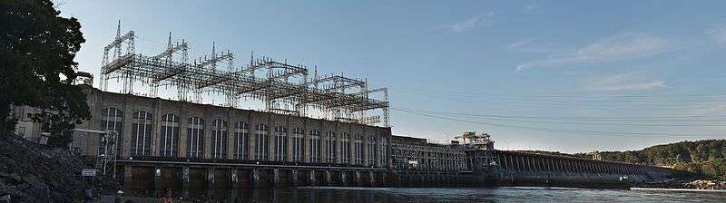
The Conowingo Dam (also Conowingo Hydroelectric Plant, Conowingo Hydroelectric Station) is a large hydroelectric dam in the lower Susquehanna River near the town of Conowingo, Maryland. The medium-height, masonry gravity dam is one of the largest non-federal hydroelectric dams in the U.S.
The dam sits about 9.9 miles (16 km) from the river mouth at the Chesapeake Bay, 5 miles (8 km) south of the Pennsylvania border and 45 miles (72 km) northeast of Baltimore, on the border between Cecil and Harford counties.
The dam supports a 9,000-acre reservoir, which today covers the original town of Conowingo. During dam construction, the town was moved to its present location about 1-mile (1.6 km) northeast of the dam's eastern end. The rising water also would have covered Conowingo Bridge, the original U.S. Route 1 crossing, so it was demolished in 1927.
The Conowingo Reservoir, and the nearby Susquehanna State Park, provide many recreational opportunities.
Construction and hydroelectric power generation
.jpg)
The area, which appears on a 1612 map by John Smith, was originally known as Smyth's Falls.
On January 23, 1925, Philadelphia Electric Company awarded the construction contract for the dam to Stone & Webster of Boston,[1] who did the design. Construction, which started in 1926, was carried out by Arundel Corporation of Maryland.[2] (Abandoned railroad tracks for transporting heavy equipment to the dam site can be seen along the western shore of the river below the dam.) When completed in 1928, it was the second-largest hydroelectric project by power output in the United States after Niagara Falls.[3]
The dam was built with 11 turbine sites, although only seven turbines were initially installed, driving generators each rated for 36 megawatts. A turbine house, on the southwestern end of the dam, encloses these seven units. One additional "house" unit provides 25 Hz power for the dam's electric railroad system (identical to that used by the Pennsylvania Railroad, which had an electrified line [now under Norfolk Southern ownership] running on the eastern shore). In 1978, four higher-capacity turbines were added. Each drives a 65-megawatt generator, increasing the dam's electrical output capacity from 252 to 548 megawatts. The four newer turbines are in the open air section at the northeast end of the power house. The generators produce power at 13,800 volts. This is stepped up to 220,000 volts for transmission, primarily to the Philadelphia area. The dam currently contributes an average of 1.6 billion kilowatt hours annually to the electric grid.
Through subsidiaries and mergers, the dam is now operated by the Susquehanna Electric Company, part of Exelon Power Corporation. The current Federal Energy Regulatory Commission license for the dam, which may be renewed, was issued in 1980 and expires on September 1, 2015.[4][5]
The Conowingo Hydroelectric Station would be a primary black start power source if the regional PJM power grid ever had a widespread emergency shutdown (blackout)[6][7]
Flood control

The dam also has 53 flood control gates, starting at the northeastern end of the powerhouse and spanning the majority of the dam. The flood gates are operated by three overhead cranes rated for 60 short tons (53.6 long tons; 54.4 t) each and built by the Morgan Engineering Company of Ohio. The cranes run on rails the length of the dam and are electrically powered from lines that run above the face of the dam. An additional crane was recently (c. 2006) installed at the power house end of the rails, which required installing new power rails below the existing power wires.
In 1936, all the flood gates were opened. During Hurricane Agnes, in 1972, all 53 flood gates were opened, for only the second time, and explosives planted to blow a section of the weir, as the waters rose during the early morning hours of June 24 within 5 feet (1.52 m) of topping the dam (a record crest of 111.5 ft (34.0 m), 3 feet (0.91 m) above normal level for the entire 14-mile (23 km) long Conowingo Reservoir.) Paul English, dam superintendent, released a bulletin at 10:30 p.m. on June 23 saying that the water levels were reaching a point at which the stability of the dam "cannot be controlled. When it reaches 111 feet (33.8 m)...it will be in the hazy area...It is not known...whether a structure of the dam may give and...people downstream should be advised."[8] At this time, the flow sensor in the dam recorded its record discharge of 1,130,000 cu ft/s (32,000 m3/s), and the stream height gauge, at the dam's downstream side, registered a record 36.85 feet (11.23 m).[9] On January 20, 1996, the gauge recorded its second-highest recorded crest of 34.18 feet (10.42 m).[9] A severe ice jam also developed behind the dam on this date. The record minimum recorded discharge was on March 2, 1969, when the flow sensor registered 144 cu ft/s (4.1 m3/s).
On September 9, 2011, 44 flood gates were opened due to the impact of the remnants of Tropical Storm Lee. The Susquehanna River behind the dam was 32.41 feet (9.88 m), the third-highest in history. The town of Port Deposit, located 5 miles southeast of the dam, was evacuated.[10]
Ecology and environmental impacts
| Conowingo Dam bridge | |
|---|---|
| Carries |
Two lanes of |
| ID number | 100000120001010 |
| Characteristics | |
| Width | 20 ft (6.1 m) |
| Statistics | |
| Daily traffic | 8850 (in 2002) |
_in_northeastern_Harford_County%2C_Maryland%2C_approaching_the_southwest_end_of_the_Conowingo_Dam_on_the_Susquehanna_River.jpg)
The river water impounded by the dam forms the 14-mile (23 km) long Conowingo Reservoir, known locally as Conowingo Lake. The reservoir is used as a drinking water supply for Baltimore and the Chester Water Authority; as cooling water for the Peach Bottom Nuclear Generating Station; and for recreational boating and fishing (like the dam itself, the launching ramps are adjacent to the Peach Bottom plant and subject to strict security measures). The area below the dam is excellent for fishing (it was the northernmost point allowed by the Bass Anglers Sportsman Society (B.A.S.S.) for its 1991 BASSMasters Classic when it held the tournament on the Chesapeake Bay Watershed). In low rainfall or drought conditions, balancing the need to maintain the reservoir level with the water flow needs for the downstream ecology is one of the challenges faced by the dam operators.[11]
The area below the dam is excellent for birdwatching. At least 170 species of birds have been observed and recorded at the dam. Large groups of great blue herons and bald eagles, sometimes well over 100 of each species, have been observed at the dam. The largest numbers of eagles are present in November, and the largest numbers of herons are present in the winter months.[12]
The Conowingo Dam, and to a lesser extent the Holtwood and Safe Harbor Dams further upstream, stopped migratory fish species, especially American shad, from swimming further up the Susquehanna River to spawn. In 1984, a fish capture feature was added at Conowingo and shad were trucked upstream above all three dams and released. This program ended in 1999. A fish lift was installed in 1991. All three dams completed installation of fish lifts in time for the 2000 season. During the 2000 migration season, 153,000 American shad passed through the Conowingo fish lift. "However, passage rates of shad from Conowingo to Holtwood have been only 30 to 50 percent, suggesting that fish are having difficulty moving upstream in the waters of the Conowingo pool."[13]
The three dams are also involved with another ecological concern. Normally, the reservoirs above each dam trap sediment and nutrients that run off from the watershed and prevent some of that from reaching the Chesapeake Bay. A 1998 USGS study suggests that they may reach capacity before 2020, and cease to reduce the nutrient and sediment load hitting the bay. However, the scouring of major floods, and other factors, affect this.[14]
See also
References
- ↑ "PRR Chronology 1926 (citing New York Times)" (PDF).
- ↑ "History Matters! Interpretive Plan for the Lower Susquehanna Heritage Greenway" (PDF). p. 162. Archived from the original (PDF) on February 24, 2006. Retrieved 2006-07-15.
- ↑ "A Hydro Plant That Rivals Niagara." Popular Science Monthly, November 1930, p. 49.
- ↑ Power Plant Research Program (February 2008). "Maryland Power Plants and the Environment: A Review of the Impacts of Power Plants and Transmission Lines on Maryland's Natural Resources". Maryland Department of Natural Resources. p. 93. Retrieved 2008-08-30.
- ↑ Wheeler, Timothy (November 19, 2014). "State could deny key Conowingo permit". The Baltimore Sun. Retrieved 27 January 2015.
- ↑ "Exelon Corporation: Conowingo". Retrieved 20 February 2011.
- ↑ "Conowingo Hydroelectric Project (FERC No. 405)". Low Impact Hydropower Institute. June 23, 2008. Archived from the original on May 10, 2008. Retrieved 2008-11-14.
- ↑ http://www.portdeposit.org/?a=history_detail and The Baltimore Sun, June 24, 1972
- 1 2 Historical Crests for Susquehanna River at Conowingo Dam
- ↑ "Waiting is over for Maryland river towns, as Susquehanna waters recede". Retrieved 2011-09-10.
- ↑ "CONOWINGO POOL MANAGEMENT PLAN" (PDF). Retrieved 2006-07-22.
- ↑ eBird: An online database of bird distribution and abundance (web application). Version 2. eBird, Ithaca, New York. Available: . (Accessed: Feb. 21, 2008).
- ↑ "Migratory Fish Restoration and Passage On the Susquehanna River". Safe Harbor Water Power Corporation. Retrieved 2008-02-08.
- ↑ "USGS Fact Sheet 003-98". 1998. Retrieved 2009-11-28.
- Safe Harbor Water Power Corporation, Conestoga, PA. "How Fish Lifts Work."
External links
-
 Media related to Conowingo Dam at Wikimedia Commons
 - U.S. Geological Survey. Conowingo Dam real-time water flow data
- Thinkquest (Oracle Education Foundation). "Conowingo Hydroelectric Plant." - Virtual tour with interior pictures and diagrams
- National Weather Service. NWS Flood Stage Info. for Susquehanna River at Conowingo
| Bridges of the Susquehanna River | ||||
|---|---|---|---|---|
| ||||