Southern Maryland
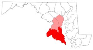
Southern Maryland in popular usage is composed of the state's southernmost counties on the "Western Shore" of the Chesapeake Bay in the state of Maryland. This region includes all of Calvert, Charles, and St. Mary's counties and sometimes the southern portions of Anne Arundel and Prince George's counties.
History
Native Americans and first contact with the English
Southern Maryland was originally inhabited by Piscataway Indians. Captain John Smith explored the area in 1608 and 1609.[1] In 1634 St. Mary's City, at southern Maryland's lower tip was the site of Maryland's first colonial settlement. It was also the first Roman Catholic English settlement in North America. Today, two thirds of the original site is now a large living history museum complex and archeological research area and the other third is now the campus of St. Mary's College of Maryland.
The early Maryland colony
The colony originally focused on tobacco farming and was very successful although disease was a problem and many settlers died until immunities built up in the population. Religious tensions and also periods of open conflict also continued to be a major challenge.
St. Mary's City is widely considered to be the birthplace of religious freedom in North America.[2] The colony there started under a mandate of religious tolerance in a time when England was anything but religiously tolerant. There was still much religious strife in St. Mary's City that led to passage of one of the earliest laws requiring religious tolerance which was written and passed there by the Maryland colonial assembly. The first woman to ever request a vote in English speaking North America is very likely to have occurred there as well.
The fall of St. Mary's City
After 61 years as Maryland's capital an uprising of Protestants put an end to religious tolerance, overthrowing the old Catholic leadership and putting an end to colonial St. Mary's City itself, moving the colonial capital to Annapolis.[3][4][5]
Plantation economy and slavery
St. Mary's was abandoned as a settlement,[6][7] but tobacco and later, also wheat plantations expanded there [7] and in Southern Maryland as a whole during the slavery era.
The plantation system is believed to have contributed to rural poverty even before the end of slavery as it depressed the local labor market and stunted other forms of economic growth. Poverty and ignorance grew and the area became known for lack of education and rural impoverishment, except for a tiny handful of plantation owners.
Civil War
During the American Civil War, wartime sympathies, although divided in Maryland, leaned much more strongly towards the South,[8] especially in Southern Maryland. From the war's beginning, however, large numbers of Union occupying troops and patrolling river gunboats prevented the state's secession, although nighttime smuggling across the Potomac River with Virginia took place. John Wilkes Booth was helped by some people in his escape through the area after killing President Abraham Lincoln.
Transition to modern era
Southern Maryland was traditionally a rural, agricultural, oyster fishing and crabbing region; linked by passenger and freight steamboat routes. These steamboat routes operated on the Chesapeake Bay and major rivers until the 1930s before the building of highways and the Harry W. Nice Memorial Bridge on U.S. Highway 301. (The latter highway was named after Robert Crain, an attorney who owned the state's largest farm, Mount Victoria, and who campaigned for the road's construction). Weekend excursion boats also carried Washingtonians to small amusement parks and amusement pavilions at numerous shore locations. From 1949 (1943 in some places) to 1968, the region was known for its poverty and its slot machine gambling.
Raley's campaign to modernize St. Mary's County
There was a lot of rural poverty at the time,[9] and the gambling came to be seen as a blight and was finally outlawed by Governor J. Millard Tawes and the state legislature.[10] A local political figure, St. Mary's County politician J. Frank Raley, Jr. organized a slate of local candidates with the platform of challenging the old political machine and lifting the region out of its generations long poverty.[10]
Raley led the way in ending the region's isolation[9][11] by having a series of bridges built and roads expanded into highways.[9][11] Raley is largely credited for enabling the development of modern St. Mary's County.[9][11]
He was falsely accused of working to end gambling outright in the region,[10] which ended in his defeat and his official political career.[10] In fact he had supported a referendum on gambling which would have put the decision directly in the hands of voters.[10] He continued nevertheless lobbying on behalf of the Southern Maryland region and sitting on development boards and so continued to have a major influence in favor of economic development in the region for the rest of his life.[11]
Population and economics
During recent times, the region experienced suburban development as the Washington suburbs expanded southward. This expansion took place primarily in Prince George's County, and around Waldorf (a regional shopping hub) and St. Charles (a planned community in Charles County), Lexington Park (St. Mary's County) and Prince Frederick (Calvert County). This expansion of the Washington DC metropolitan area has caused much of southern Maryland's formerly predominant southern culture to fade giving way to a rapidly growing northeastern culture that is found throughout much of the Northeast Megalopolis.[12] However, as noted, land-use maps show that the area is still primarily low-density.[13]
Many southern Marylanders work at Andrews Air Force Base, the U.S. Census Bureau or at Patuxent River Naval Air Station and its related industries. Other smaller industries include a nuclear power plant[14] and a liquified natural gas terminal[15] (both in Lusby), a Naval ordnance test ground (at Indian Head),[16] electric power plants (at Aquasco and Morgantown)[17] and an oil terminal[18] (at Piney Point). The beautiful towns of Solomons Island and Chesapeake Beach are favorite weekend tourist resorts. Maryland International Raceway and Budds Creek Raceway near Chaptico attract many auto and motocross racing enthusiasts.
While the steamboats are long gone, more than three-quarters of the land area is still rural, a mixture of forest and farmland.[19] The growing of tobacco, once a dominant crop, has declined greatly because of state government farm buyouts during the 1990s.
St. Mary's County is home to Amish and Mennonite communities. In addition, two state recognized tribes exist Piscataway Native American tribe, tribes that live along the Potomac River and Chesapeake Bay in southern Maryland (see We-Sorts). Fishing, boating and crabbing are popular activities in this region; large marinas are found in the Solomons Island and North Beach areas. However, the population of fish and other marine life is threatened by pollution and environmental factors. Ancient marine fossils are abundant at Calvert Cliffs.
Geography
The region's northern boundary passes through Prince George's County and Anne Arundel County, east of Washington. Its eastern boundary is the Chesapeake Bay and its southern and western boundary is the Potomac River, Maryland's boundary with Virginia.
Food and cuisine
Perhaps the most notable food dish originating from Southern Maryland is stuffed ham, which is cabbage, kale, onions, spices and seasonings that are chopped and mixed, then stuffed into deep slits slashed in a whole, corned ham.[20]
Seafood is popular amongst Southern Marylanders, given the region's location along the Chesapeake Bay and its tributaries. Both steamed crabs and crab cakes are considered Southern Maryland delicacies due to the large amount of harvesting of blue crabs from the bay. Also popular are oysters, which were once fished from the bay in great numbers, and served either fried, raw, or stuffed. Rockfish is considered one of the most prized fish dishes in Southern Maryland.[21]
Towns and communities
Towns and places in Southern Maryland include:
Anne Arundel County:
Calvert County:
- Chesapeake Beach
- Dunkirk
- Huntingtown
- Lusby
- North Beach
- Prince Frederick (county seat)
- Port Republic
- St. Leonard
- Solomons
Charles County:
- Bel Alton
- Bryans Road
- Bryantown
- Cobb Island
- Dentsville
- Indian Head
- Hughesville
- La Plata (county seat)
- Nanjemoy
- Pomfret
- Potomac Heights
- St. Charles
- Waldorf
- White Plains
Prince George's County:
- Accokeek
- Brandywine
- Cheltenham
- Clinton
- Eagle Harbor
- Fort Washington
- Piscataway
- Upper Marlboro (county seat)
St. Mary's County:
- California
- Charlotte Hall
- Hollywood
- Leonardtown (county seat)
- Lexington Park
- Mechanicsville
- Ridge
- St. Mary's City
Sports
| Club | League | Venue | Established | Championships |
|---|---|---|---|---|
| Southern Maryland Blue Crabs | ALPB, Baseball | Regency Furniture Stadium | 2008 | 0 |
Colleges
Colleges in Southern Maryland include:
- The College of Southern Maryland, a community college with campuses in Charles, Calvert, and St. Mary's counties
- St. Mary's College of Maryland, in St. Mary's City
Notable Southern Marylanders
- Rep. Steny Hoyer (D), Minority Leader of the United States House of Representatives, represents southern Maryland as the representative for Maryland's 5th congressional district. He lives in Mechanicsville.
- Two former first ladies hail from southern Maryland: Louisa Catherine Johnson Adams, wife of John Quincy Adams, and Margaret Mackall Smith Taylor, wife of Zachary Taylor.
- Co-discover of the North Pole, Matthew Henson and Captain Raphael Semmes of the CSS Alabama were born near Nanjemoy, Charles County. Prominent revolutionary war statesmen John Hanson, Thomas Stone, and General Smallwood were from Charles County. Dr. Samuel Mudd, convicted of conspiracy to murder in the Abraham Lincoln assassination, was also a native of Charles County.
- Television journalists Ted Koppel, Judy Woodruff, Al Hunt, newspapermen Ben Bradlee and Sally Quinn, and weatherman Doug Hill all have houses in St. Mary's County.
- Theoretical ecologist Dr. Robert Ulanowicz lived in Calvert County prior to his retirement in 2008 with Chesapeake Biological Laboratory in Solomons, where he was a member of the faculty.
- Roger B. Taney, the Chief Justice of the United States who presided over the Dred Scott decision, was born in Calvert County near Prince Frederick.
- Former Comptroller of Maryland Louis L. Goldstein lived in Calvert County. A portion of MD 2/MD 4 in Calvert County was renamed in his honor after his death.
- Stephanie Roper, noted victim of crime.[22] A portion of MD 4 was renamed in her honor after her death.
- Arthur Storer, first astronomer in the American colonies and the original namesake for Halley's Comet, lived the latter part of his life in Calvert County. A planetarium in Prince Frederick bears his name.
- Thomas Johnson, the first elected governor of Maryland and Associate Justice of the Supreme Court of the United States. The Governor Thomas Johnson Bridge connecting Calvert and St. Mary's counties was named in his honor.
- Television and film screenwriter and producer Alfred Gough hails from Leonardtown in St. Mary's County.
- Former Maryland State Senator and Patuxent River advocate Bernie Fowler lives in Calvert County. Every year, in Broomes Island Fowler will hold a "wade-in" with other public officials to help determine the clarity levels of the Patuxent.
- Singer Christina Milian once lived in Waldorf.[23]
- Joel and Benji Madden from the band Good Charlotte grew up in Waldorf.[24]
- Turkey Tayac, Piscataway tribal leader and herbal medicine man
- Robert Stethem, murder victim during hijacking of TWA Flight 847 was from Pinefield, the northern section of Waldorf
- Senator and astronaut John Glenn trained at Patuxent River Naval Air Station many years ago, as did Alan Shepard and other future astronauts.
- Dashiell Hammett, author of hard-boiled detective novels (creator of the "Maltese Falcon" and "The Thin Man") and short stories, and a screenplay writer, was born in St. Mary's County.
- Danny Gatton, guitarist, resided in Accokeek and Newburg.
- Eva Cassidy, interpretive vocalist and guitarist, lived in Oxon Hill and Bowie.
- Link Wray, pioneering rock guitarist, lived in Accokeek.
- professional wrestler and WWE Hall of Famer Scott Hall was born in St. Mary's County.
References
| Wikivoyage has a travel guide for Southern Maryland. |
- ↑ Christine Wright (2002). "Capt. John Smith's 1608 Chesapeake Voyage". Calvert Marine Museum. Retrieved 2007-12-08.
He explored the lower Chesapeake Bay in 1607. - ↑ "Reconstructing the Brick Chapel of 1667" Page 1, See section entitled "The Birthplace of Religious Freedom" https://stmaryscity.org/wp-content/uploads/2013/07/Chapel-Reconstruction.pdf
- ↑ "ST. MARY'S COUNTY, MARYLAND: HISTORICAL CHRONOLOGY", Maryland Manual Online, Maryland State Archives, Government of the State of Maryland, http://msa.maryland.gov/msa/mdmanual/36loc/sm/chron/html/smchron.html
- ↑ Maclear, J.F. (1995). Church and State in the Modern Age: A Documentary History. New York: Oxford University Press US. ISBN 0-19-508681-3
- ↑ "The Enduring Vision: A History of the American People, Volume I: To 1877", By Paul Boyer, Clifford Clark, Karen Halttunen, Sandra Hawley, Joseph Kett, "Chapter: 4 The Bonds of Empire: 1660-1740" page 70, Cengage Learning, publisher, Jan 1, 2012,
- ↑ Frank D. Roylance, Evening Sun, "They're unearthing more than a chapel at St. Mary's site BURIED PAST", November 13, 1990 http://articles.baltimoresun.com/1990-11-13/news/1990317111_1_chapel-mary-city-brick
- 1 2 Kenneth K. Lam, "Unearthing early American life in St. Mary’s City: St. Mary’s City is an archaeological jewel on Maryland’s Western Shore", Baltimore Sun, Aug 30, 2013, http://darkroom.baltimoresun.com/2013/08/unearthing-early-american-life-in-st-marys-city/#1
- ↑ "Civil War in Maryland: Southern Sympathizers", aryland State Archives, June 25, 2004, http://teaching.msa.maryland.gov/000001/000000/000114/html/t114.html
- 1 2 3 4 "Raley remembered as architect of modern St. Mary’s: Former state senator dies at 85; slots ended, bridge created through his work", Jason Babcock, Staff writer http://www.somdnews.com/article/20120822/NEWS/708229616/1044/news&source=RSS&template=gazette
- 1 2 3 4 5 "For 21 years, slot machines ruled in St. Mary’s", Jason Babcock, Southern Maryland Newspapers, Wednesday, July 26, 2006, http://ww2.somdnews.com/stories/072606/entefea172603_32091.shtml
- 1 2 3 4 "J. Frank Raley, 85, St. Mary’s City", Southern Maryland News, Wednesday, August 22, 2012 http://www.somdnews.com/article/20120822/misc/708229670/-1/j-frank-raley-85-st-mary-s-city&template=southernmaryland
- ↑ David A. Fahrenthold (February 19, 2005). "Bay's Dialects Slowly Dying". The Washington Post. Retrieved 2007-12-08.
- ↑ "Patuxent River – 2000 Land Use / Land Cover". Maryland Department of Planning. 2000. Retrieved 2007-12-08.
- ↑ Power generation: Calvert Cliffs Nuclear Power Plant. (2006). Constellation Energy. Retrieved December 22, 2006.
- ↑ Dominion Cove Point LNG. (2005). Calvert Chamber of Commerce. Retrieved December 22, 2006.
- ↑ Indian Head division, Naval Surface Warfare Center. (n.d.). United States Department of Navy. Retrieved December 22, 2006.
- ↑ Chalk Point Generating Plant. (n.d.). Mirant Corporation. Retrieved December 22, 2006.
- ↑ Mirant Piney Point. (n.d.). Mirant Corporation. Retrieved December 22, 2006.
- ↑ "Summer 2007 — Draft Existing Conditions Summary" (PDF). Maryland Department of Transportation. 2007. Retrieved 2007-12-06.
- ↑ Alumnae (1959). Treasured Recipes of Old St. Mary's County. St. Mary's Academy.
- ↑ http://www.americanfoodroots.com/50-states/about-maryland/
- ↑ http://www.mdcrimevictims.org/about-mdcvrc/
- ↑ "Christina Milian Biography". ChristinaMilian.org - The Official Site of Christina Milian. Milian Corporation. Archived from the original on 2007-11-20. Retrieved 2007-12-14.
- ↑ Hoard, Christian (April 9, 2003). "Young, Hopeless, Rich, and Famous". Rolling Stone. Rolling Stone Australia.
Coordinates: 38°28′N 76°48′W / 38.467°N 76.800°W