Concepción de Oriente
Coordinates: 13°47′12″N 87°42′38″W / 13.78676°N 87.710487°W
| Concepción de Oriente | |
|---|---|
| Municipality | |
 Concepción de Oriente Location in El Salvador | |
| Coordinates: 13°47′N 87°43′W / 13.783°N 87.717°W | |
| Country |
|
| Department | La Unión Department |
| Elevation | 410 ft (125 m) |
| Population (2004) | |
| • Total | 7,130 |
Concepción de Oriente is a municipality in the La Unión department of El Salvador.
The municipality borders the Goascorán River. The river divides El Salvador and Honduras and serves as the borderline in El Salvador's eastern part of the country. The villa itself runs into the river. There is no bridge connecting the municipality to Honduras. The villa used to be known as "Saco". There are paved roads that lead from the nearest big city of Santa Rosa de Lima, La Unión. The "fiestas patronales" are in the first week of January.
Had the highest percent of remittances in El Salvador in 2005.
Migration and Development in El Salvador: Ideals Versus Reality
Capital: La Unión | ||
| Municipalities | 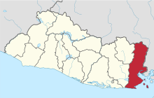 | |
This article is issued from Wikipedia - version of the 8/20/2013. The text is available under the Creative Commons Attribution/Share Alike but additional terms may apply for the media files.