La Unión Department
| La Unión | ||
|---|---|---|
| Department | ||
 | ||
| ||
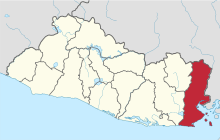 Location within El Salvador | ||
| Coordinates: 13°32′31″N 87°52′48″W / 13.542°N 87.88°WCoordinates: 13°32′31″N 87°52′48″W / 13.542°N 87.88°W | ||
| Country |
| |
| Created (given current status) | 1865 | |
| Seat | La Unión | |
| Area | ||
| • Total | 2,074.3 km2 (800.9 sq mi) | |
| Area rank | Ranked 3rd | |
| Population | ||
| • Total | 263,271 | |
| • Rank | Ranked 8th | |
| • Density | 130/km2 (330/sq mi) | |
| Time zone | CST (UTC−6) | |
| ISO 3166 code | SV-UN | |

La Unión is a department of El Salvador. It is located in the eastern part of the country and its capital is La Unión. It covers a total of 2,074 km² and has a population of 263,200. The department was created on June 22, 1865 and the city of La Unión was made its capital. The Conchagua Temple was built in 1693 and it is one of tourist attractions of the department, as well as containing archeological ruins in Intipuca and Meanguera.
Municipalities
- Anamorós
- Bolívar
- Concepción de Oriente
- Conchagua
- El Carmen
- El Sauce
- Intipucá
- La Unión
- Lislique
- Meanguera del Golfo
- Nueva Esparta
- Pasaquina
- Polorós
- San Alejo
- San José
- Santa Rosa de Lima
- Yayantique
- Yucuaiquín
Agriculture
The most important agricultural products are: coffee, grass, fruits, cocoa, oleaginous seeds, and sugar cane. The manufacture of palm objects, tortoiseshell objects, panela, mangrove extraction, and fish. It has locations of gold, iron, barium, and mercury.
External links
References
This article is issued from Wikipedia - version of the 9/14/2014. The text is available under the Creative Commons Attribution/Share Alike but additional terms may apply for the media files.