Compton Chamberlayne
| Compton Chamberlayne | |
 Compton Chamberlayne |
|
 Compton Chamberlayne |
|
| Population | 112 (in 2011)[1] |
|---|---|
| OS grid reference | SU029300 |
| Unitary authority | Wiltshire |
| Ceremonial county | Wiltshire |
| Region | South West |
| Country | England |
| Sovereign state | United Kingdom |
| Post town | Salisbury |
| Postcode district | SP3 |
| Dialling code | 01722 |
| Police | Wiltshire |
| Fire | Dorset and Wiltshire |
| Ambulance | South Western |
| EU Parliament | South West England |
| UK Parliament | South West Wiltshire |
Coordinates: 51°04′08″N 1°57′36″W / 51.069°N 1.960°W
Compton Chamberlayne is a small village and civil parish in south Wiltshire, England, situated in the Nadder Valley approximately 7 miles (11 km) west of Salisbury. The River Nadder forms the northern border of the parish, and to the south are chalk hills. The parish is bisected by the A30 road. The village contains approximately 25 privately owned houses, a village hall, and a cricket pitch used by the Compton Chamberlayne Cricket Club.[2]
History
Most of the inhabited part of the village lies within a small wooded valley which lends credence to the origin of the name "Compton" – coombe tun, or 'settlement in a wooded valley'. The 'Chamberlayne' seems to have been attached when a Robert le Chamberlayne, or possibly Geoffrey le Chaumberlang, took possession of the village in the Middle Ages. The village was recorded in the Domesday Book of 1086, which shows that at that time the local manor had a mill, some pastureland, meadows and two woods.[3] Today there is no evidence of the manor.
There was a day school in the village in 1819, which had 60 pupils in 1859; around this time it was funded entirely by the Penruddock family of Compton House. By 1871, government grants were received under the National School system. The school closed in 1933 owing to falling pupil numbers.[4]
During World War I there were thousands of Australian and Canadian troops encamped in the fields below the chalk downland before being shipped to France for combat. Compton Chamberlayne burial ground has about 20 graves of Australian soldiers who died, believed to be of influenza, during their transit through the local camp. There is still today a field called 'hospital', previously the site of the military medical facility. The only tangible sign of the previous occupation was the outline of Australia carved in the surface of the chalk downs (grid reference SU 04298 29163) to the southeast of the village,[5] which was left to grass over in 2005. The neighbouring village of Fovant however boasts an impressive display of army regimental badges carved into the chalk downs. Compton Chamberlayne also features a folly in the form of a summer house at 51°04′16″N 1°57′19″W / 51.07114°N 1.95523°W.
Parish church

The Anglican church of St Michael stands close to Compton House. The church was built at the end of the 13th century in the Early English style, at the same time as Salisbury Cathedral was being constructed some 7 miles away. Further work was carried out in the 14th and 15th centuries, with restoration in 1877 by James Soppitt of Shaftesbury.[6] The church contains the Penruddocke family vault and has a peal of six bells, two dating from the 17th century and four from the 19th century.[7]
The church is a Grade II* listed building[8] and is served by the Nadder Valley team ministry.[9]
Compton House
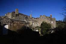
Compton House (or Compton Park House) was the seat of the Penruddocke (or Penruddock) family from the mid-16th century until 1930.[10]
The present house may be on the site of a medieval manor house; Pevsner saw fragments of medieval work.[11] It was refitted internally by Sir Edward Penruddocke in the late 17th century and rebuilt externally in 1780 by Charles Penruddocke. The drawing room of c. 1700 has panelling and richly carved decoration in Grinling Gibbons style, and a plaster ceiling from the same period. In the dining room, part of the 1780 additions, is a plaster ceiling in Adam style. The stable block is also from the late 18th century.[12] The house is a Grade I listed building.[13]
The house is set in parkland, formerly a medieval deer park, and overlooks an artificial lake formed by damming a stream which runs north into the Nadder.[14] Landscaping in the 18th century was by Capability Brown.[10]
Notable residents
- Sir George Penruddock (d. 1581), High Sheriff of Wiltshire; MP for Salisbury, Wiltshire and Downton
- John Penruddock (d. 1601), MP for Wilton and Southampton
- Edward Penruddock, High Sheriff in 1597
- Sir John Penruddocke (d. 1648), High Sheriff in 1643
- Colonel John Penruddock (1619–1655), a royalist who took part in a failed uprising against Oliver Cromwell, known as the Penruddock uprising, in 1655; tried and executed at Exeter on 16 May 1655
- Thomas Penruddocke (b. about 1648, d. before 1695), MP for Wilton
- Charles Penruddocke (d. 1788), High Sheriff in 1751
- Charles Penruddocke (1743–88), High Sheriff, MP for Wiltshire
- John Penruddocke (1770–1841), High Sheriff, MP for Wilton
- Charles Penruddocke (d. 1899), High Sheriff in 1861
References
- ↑ "Wiltshire Community History – Census". Wiltshire Council. Retrieved 15 December 2014.
- ↑ "Compton Chamberlayne Cricket Club"
- ↑ Compton Chamberlayne in the Domesday Book
- ↑ Craven, Alex. "Wiltshire: Work in progress: Compton Chamberlayne: Education" (PDF). Victoria County History. University of London. Retrieved 28 April 2016.
- ↑ Historic England. "Chalk map of Australia 925m south west of Upper Hurdcott Farm (1020133)". National Heritage List for England. Retrieved 26 April 2016.
- ↑ Craven, Alex. "Wiltshire: Work in progress: Compton Chamberlayne: Religious history" (PDF). Victoria County History. University of London. Retrieved 28 April 2016.
- ↑ "St Michael's, Compton Chamberlayne" at Doves' Guide
- ↑ Historic England. "Church of St Michael (1198624)". National Heritage List for England. Retrieved 27 April 2016.
- ↑ "St Michael, Compton Chamberlayne". A Church Near You. Retrieved 27 April 2016.
- 1 2 "Compton House, Compton Chamberlayne: photograph". Victoria County History. Retrieved 28 April 2016.
- ↑ Pevsner, Nikolaus; Cherry, Bridget (revision) (1975) [1963]. Wiltshire. The Buildings of England (2nd ed.). Harmondsworth: Penguin Books. p. 189-190. ISBN 0-14-0710-26-4.
- ↑ Historic England. "Stable to west of Compton Park House (1198787)". National Heritage List for England. Retrieved 28 April 2016.
- ↑ Historic England. "Compton Park House (1146151)". National Heritage List for England. Retrieved 28 April 2016.
- ↑ Craven, Alex. "Wiltshire: Work in progress: Compton Chamberlayne: Introduction" (PDF). Victoria County History. University of London. Retrieved 28 April 2016.
External links
![]() Media related to Compton Chamberlayne at Wikimedia Commons
Media related to Compton Chamberlayne at Wikimedia Commons
- Wanderings in Wessex at Project Gutenberg (Makes reference to Penruddocke.)