Teffont
| Teffont | |
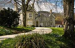 Bridges, Teffont Evias |
|
 Teffont |
|
| Population | 248 (in 2011)[1] |
|---|---|
| OS grid reference | ST990317 |
| Unitary authority | Wiltshire |
| Ceremonial county | Wiltshire |
| Region | South West |
| Country | England |
| Sovereign state | United Kingdom |
| Post town | Salisbury |
| Postcode district | SP3 |
| Police | Wiltshire |
| Fire | Dorset and Wiltshire |
| Ambulance | South Western |
| EU Parliament | South West England |
| UK Parliament | South West Wiltshire |
| Website | Teffont village |
Coordinates: 51°05′06″N 2°00′58″W / 51.085°N 2.016°W
Teffont is a civil parish in the south of Wiltshire, England, consisting of the villages of Teffont Magna and Teffont Evias. It is in the Nadder valley, about 10 miles (16 km) west of Salisbury. The population taken at the 2011 census was 248.[2]
The parish was created in 1934 by combining the two Teffonts. For most of its history Teffont Magna had been a chapelry of Dinton.[3][4]
Part of Chilmark Quarries, a former stone quarry and now a Site of Special Scientific Interest, is in the far southwest of the parish.
Local government
Teffont has a parish council and is in the area of the Wiltshire Council unitary authority, which is responsible for almost all significant local government functions.
References
- ↑ "Wiltshire Community History - Census". Wiltshire Council. Retrieved 26 May 2015.
- ↑ "Parish population 2011". Office for National Statistics. Retrieved 14 March 2015.
- ↑ Teffont Magna in A History of the County of Wiltshire: Volume 8: Warminster, Westbury and Whorwellsdown Hundreds (1965), pp. 74-78
- ↑ 'Parishes: Teffont Evias' in A History of the County of Wiltshire: Volume 13: South-west Wiltshire: Chalke and Dunworth hundreds (1987), pp185-195. Retrieved 16 November 2010.
This article is issued from Wikipedia - version of the 3/29/2016. The text is available under the Creative Commons Attribution/Share Alike but additional terms may apply for the media files.