Commercial Point, Ohio
| Commercial Point, Ohio | |
|---|---|
| Village | |
 Location of Commercial Point, Ohio | |
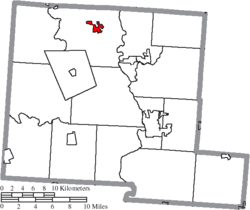 Location of Commercial Point in Pickaway County | |
| Coordinates: 39°46′19″N 83°3′37″W / 39.77194°N 83.06028°WCoordinates: 39°46′19″N 83°3′37″W / 39.77194°N 83.06028°W | |
| Country | United States |
| State | Ohio |
| County | Pickaway |
| Township | Scioto |
| Area[1] | |
| • Total | 1.13 sq mi (2.93 km2) |
| • Land | 1.13 sq mi (2.93 km2) |
| • Water | 0 sq mi (0 km2) |
| Elevation[2] | 781 ft (238 m) |
| Population (2010)[3] | |
| • Total | 1,582 |
| • Estimate (2012[4]) | 1,587 |
| • Density | 1,400.0/sq mi (540.5/km2) |
| Time zone | Eastern (EST) (UTC-5) |
| • Summer (DST) | EDT (UTC-4) |
| ZIP code | 43116 |
| Area code(s) | 614 |
| FIPS code | 39-18070[5] |
| GNIS feature ID | 1060991[2] |
Commercial Point is a village in Pickaway County, Ohio, United States. The population was 1,582 at the 2010 census.
Geography
Commercial Point is located at 39°46′19″N 83°3′37″W / 39.77194°N 83.06028°W (39.771817, -83.060215).[6]
According to the United States Census Bureau, the village has a total area of 1.13 square miles (2.93 km2), all of it land.[1]
Gallery
-

Commercial Point community sign
-
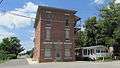
Independent Order of Odd Fellows building
-

Commercial Point post office
-

Water towers in Commercial Point
-
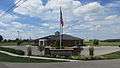
Commercial Point municipal building
Demographics
| Historical population | |||
|---|---|---|---|
| Census | Pop. | %± | |
| 1880 | 169 | — | |
| 1890 | 265 | 56.8% | |
| 1900 | 245 | −7.5% | |
| 1910 | 234 | −4.5% | |
| 1920 | 220 | −6.0% | |
| 1930 | 211 | −4.1% | |
| 1940 | 207 | −1.9% | |
| 1950 | 238 | 15.0% | |
| 1960 | 308 | 29.4% | |
| 1970 | 320 | 3.9% | |
| 1980 | 316 | −1.2% | |
| 1990 | 405 | 28.2% | |
| 2000 | 776 | 91.6% | |
| 2010 | 1,582 | 103.9% | |
| Est. 2015 | 1,611 | [7] | 1.8% |
2010 census
As of the census[3] of 2010, there were 1,582 people, 507 households, and 413 families residing in the village. The population density was 1,400.0 inhabitants per square mile (540.5/km2). There were 547 housing units at an average density of 484.1 per square mile (186.9/km2). The racial makeup of the village was 94.4% White, 1.3% African American, 0.3% Native American, 1.3% Asian, 1.0% from other races, and 1.8% from two or more races. Hispanic or Latino of any race were 2.0% of the population.
There were 507 households of which 53.1% had children under the age of 18 living with them, 67.5% were married couples living together, 9.7% had a female householder with no husband present, 4.3% had a male householder with no wife present, and 18.5% were non-families. 14.0% of all households were made up of individuals and 4.2% had someone living alone who was 65 years of age or older. The average household size was 3.12 and the average family size was 3.43.
The median age in the village was 32.1 years. 34.8% of residents were under the age of 18; 6.1% were between the ages of 18 and 24; 32.7% were from 25 to 44; 19.9% were from 45 to 64; and 6.4% were 65 years of age or older. The gender makeup of the village was 48.0% male and 52.0% female.
2000 census
As of the census[5] of 2000, there were 776 people, 277 households, and 222 families residing in the village. The population density was 712.5 people per square mile (274.9/km²). There were 288 housing units at an average density of 264.4 per square mile (102.0/km²). The racial makeup of the village was 98.07% White, 0.13% African American, 0.13% Asian, and 1.68% from two or more races. Hispanic or Latino of any race were 0.52% of the population.
There were 277 households out of which 44.0% had children under the age of 18 living with them, 66.8% were married couples living together, 9.4% had a female householder with no husband present, and 19.5% were non-families. 14.8% of all households were made up of individuals and 6.5% had someone living alone who was 65 years of age or older. The average household size was 2.80 and the average family size was 3.13.
In the village the population was spread out with 30.5% under the age of 18, 6.8% from 18 to 24, 35.3% from 25 to 44, 19.7% from 45 to 64, and 7.6% who were 65 years of age or older. The median age was 34 years. For every 100 females there were 95.5 males. For every 100 females age 18 and over, there were 93.9 males.
The median income for a household in the village was $55,563, and the median income for a family was $56,806. Males had a median income of $33,571 versus $26,625 for females. The per capita income for the village was $21,964. About 6.7% of families and 9.0% of the population were below the poverty line, including 16.2% of those under age 18 and 29.8% of those age 65 or over.
History
Wiley H. Beckett came from eastern Virginia in 1829 and settled on a 238-acre tract west of the present Commercial Point. In 1841 he laid out a town which he named Genoa.[9] James H. Burnley came from Virginia in 1832 and laid out a similar town east of Genoa and called it Rome. The first store was established in 1844 by Wiley H. Beckett. Genoa was incorporated in 1851, which encompassed Genoa and Rome. The name of the village was changed in 1872 to Commercial Point.[10]
In the media
Commercial Point and Scioto Township are featured in the Together Concepts video production "We Are..Teays Valley". The video depicts a number of achievements and innovations, as well as connections to American and world history.[11]
Notable residents
- Sarah Fisher - IndyCar Series driver
Jerry Razor - TV Personality
References
- 1 2 "US Gazetteer files 2010". United States Census Bureau. Archived from the original on 2012-07-14. Retrieved 2013-01-06.
- 1 2 "US Board on Geographic Names". United States Geological Survey. 2007-10-25. Retrieved 2008-01-31.
- 1 2 "American FactFinder". United States Census Bureau. Retrieved 2013-01-06.
- ↑ "Population Estimates". United States Census Bureau. Archived from the original on 2013-06-17. Retrieved 2013-06-17.
- 1 2 "American FactFinder". United States Census Bureau. Archived from the original on 2013-09-11. Retrieved 2008-01-31.
- ↑ "US Gazetteer files: 2010, 2000, and 1990". United States Census Bureau. 2011-02-12. Retrieved 2011-04-23.
- ↑ "Annual Estimates of the Resident Population for Incorporated Places: April 1, 2010 to July 1, 2015". Retrieved July 2, 2016.
- ↑ "Census of Population and Housing". Census.gov. Archived from the original on April 22, 2013. Retrieved June 4, 2015.
- ↑ Overman, William Daniel (1958). Ohio Town Names. Akron, OH: Atlantic Press. p. 32.
- ↑ http://www.rootsweb.ancestry.com/~ohpickaw/histories/history_of_pickaway_county.htm
- ↑ A New Film Sheds Light on Local Achievements
Municipalities and communities of Pickaway County, Ohio, United States | ||
|---|---|---|
| City | 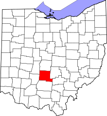 | |
| Villages | ||
| Townships | ||
| CDPs | ||
| Unincorporated communities | ||
| Ghost town | ||
| Footnotes | ‡This populated place also has portions in an adjacent county or counties | |