Colorado City, Colorado
| Colorado City, Colorado | |
|---|---|
| CDP | |
|
Colorado City in late 2014. | |
 Location in Pueblo County and the State of Colorado | |
| Coordinates: 37°56′43″N 104°50′27″W / 37.94528°N 104.84083°WCoordinates: 37°56′43″N 104°50′27″W / 37.94528°N 104.84083°W | |
| Country |
|
| State |
|
| County | Pueblo County[1] |
| Government | |
| • Type | unincorporated community |
| Area | |
| • Total | 34.6 sq mi (89.5 km2) |
| • Land | 34.5 sq mi (89.3 km2) |
| • Water | 0.1 sq mi (0.2 km2) |
| Elevation[1] | 5,853 ft (1,784 m) |
| Population (2010) | |
| • Total | 2,193 |
| • Density | 58.3/sq mi (22.5/km2) |
| Time zone | MST (UTC-7) |
| • Summer (DST) | MDT (UTC-6) |
| ZIP Code[2] | 81019 |
| Area code(s) | 719 |
| FIPS code | 08-15935 |
| GNIS feature ID | 0204804 |

Colorado City is a census-designated place (CDP) in Pueblo County, Colorado, United States. It is part of the Pueblo Metropolitan Statistical Area. The population was 2,193 at the 2010 census.[3][4] The Colorado City Post Office has the ZIP Code 81019.[2]
Newspapers that cover Colorado City include the local Greenhorn Valley View paper and The Pueblo Chieftain.
Geography
Colorado City is located at 37°56′43″N 104°50′27″W / 37.94528°N 104.84083°W (37.945237, -104.840885).[5]
According to the United States Census Bureau, the CDP has a total area of 34.6 square miles (90 km2), of which, 34.5 square miles (89 km2) of it is land and 0.1 square miles (0.26 km2) of it (0.23%) is water.
Located at the base of the Greenhorn valley, Colorado City blends alpine views with a climate closer to that of Colorado's Banana belt. While the elevation gives Colorado City more precipitation and greener summers than much of Colorado, it is possible to golf there year round - even with the sporadic snowfall of southern Pueblo County. Colorado City residents enjoy public parks and lands, Lake Beckwith, and easy access to state highway 165 and Interstate 25. The built environment includes banks, retailers, restaurants, and a full size grocery store. Much of Colorado City is open space, and so a high percentage of Colorado City's area is owned and managed by the Colorado City Metropolitan District and will remain pristine for generations to come.
Demographics
As of the census[4] of 2000, there were 2,018 people, 760 households, and 582 families residing in the CDP. The population density was 58.5 people per square mile (22.6/km²). There were 845 housing units at an average density of 24.5 per square mile (9.5/km²). The racial makeup of the CDP was 92.57% White, 0.99% African American, 1.88% Native American, 0.20% Asian, 0.05% Pacific Islander, 2.38% from other races, and 1.93% from two or more races. Hispanic or Latino of any race were 9.17% of the population.
There were 760 households out of which 36.1% had children under the age of 18 living with them, 64.7% were married couples living together, 8.7% had a female householder with no husband present, and 23.4% were non-families. 18.9% of all households were made up of individuals and 7.4% had someone living alone who was 65 years of age or older. The average household size was 2.66 and the average family size was 3.04.
In the CDP the population was spread out with 28.9% under the age of 18, 6.8% from 18 to 24, 26.8% from 25 to 44, 25.4% from 45 to 64, and 12.0% who were 65 years of age or older. The median age was 37 years. For every 100 females there were 99.2 males. For every 100 females age 18 and over, there were 92.6 males.
The median income for a household in the CDP was $37,331, and the median income for a family was $44,758. Males had a median income of $32,396 versus $21,000 for females. The per capita income for the CDP was $17,247. About 5.7% of families and 8.9% of the population were below the poverty line, including 7.8% of those under age 18 and 8.9% of those age 65 or over.
See also
References
- 1 2 "US Board on Geographic Names". United States Geological Survey. 2007-10-25. Retrieved 2008-01-31.
- 1 2 "ZIP Code Lookup". United States Postal Service. December 14, 2006. Archived from the original (JavaScript/HTML) on September 3, 2007. Retrieved December 14, 2006.
- ↑ Colorado Trend Report 2: State and Complete Places (Sub-state 2010 Census Data). Missouri Census Data Center. Accessed 2011-02-25.
- 1 2 "American FactFinder". United States Census Bureau. Archived from the original on 2013-09-11. Retrieved 2008-01-31.
- ↑ "US Gazetteer files: 2010, 2000, and 1990". United States Census Bureau. 2011-02-12. Retrieved 2011-04-23.
Municipalities and communities of Pueblo County, Colorado, United States | ||
|---|---|---|
| City | 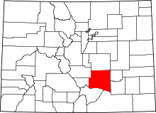 | |
| Towns | ||
| CDPs | ||
| Unincorporated communities | ||
| Ghost town | ||