Cobly
| Cobly | |
|---|---|
| Commune, arrondissement and town | |
 | |
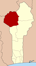
 Cobly Location in Benin | |
| Coordinates: 10°29′32″N 0°59′59″E / 10.49222°N 0.99972°ECoordinates: 10°29′32″N 0°59′59″E / 10.49222°N 0.99972°E | |
| Country |
|
| Department | Atakora Department |
| Area | |
| • Total | 825 km2 (319 sq mi) |
| Population | |
| • Total | 46,660 |
| • Density | 57/km2 (150/sq mi) |
| Time zone | WAT (UTC+1) |
Cobly or Kobli is a town, arrondissement and commune in the Atakora Department of north-western Benin.
The commune covers an area of 825 square kilometres and as of 2002 had a population of 46,660 people.[1][2]
Geography
The town of Cobly is located 645 kilometres from Cotonou and 106 kilometres from the department capital of Natitingou.[1] Communally it is bounded to the north by Matéri, south by Boukoumbé, west by Togo and east by Tanguiéta.[1]
Administrative divisions
Cobly is subdivided into 4 arrondissements; Cobly, Datori, Kountori and Tapoga. They contain 17 villages and 9 urban districts.[1]
Economy

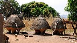
Most of the population are engaged in agricultural activities followed by trade, transportation and handicrafts. The main crops grown are sorghum, cowpeas, yams and rice.[1]