Kouffo Department
| Kouffo | |
|---|---|
| Department | |
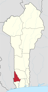 Map highlighting the Kouffo Department | |
| Coordinates: 6°57′43″N 1°48′06″E / 6.96194°N 1.80167°ECoordinates: 6°57′43″N 1°48′06″E / 6.96194°N 1.80167°E | |
| Country |
|
| Capital | Dogbo-Tota |
| Area[1] | |
| • Total | 2,404 km2 (928 sq mi) |
| Population (2013 census) | |
| • Total | 741,895 |
| • Density | 310/km2 (800/sq mi) |
| Time zone | WAT (UTC+1) |
Kouffo is one of the twelve departments of Benin. Kouffo borders the country of Togo and it also borders the departments of Mono, Zou, and Atlantique. Since 2008, the capital is Aplahoué. The département of Kouffo was created in 1999 when it was split off from Mono Department.
Per 2013 census, the total population of the department was 745,328 with 348,574 males and 396,754 females. The proportion of women was 53.20 per cent. The total rural population was 72.20 percent, while the urban population was 27.80 per cent. The total labour force in the department was 208,974 out of which 52.60 per cent were women. The proportion of households with no level of education was 68.60.
Geography
Kouffo is characterized by plateaus ranging from 20 m (66 ft) above the mean sea level. The plateaus are split by valleys running from north to south, created by the Sahoua River and Kauoffo river.[2][3] Kouffo river plateaus contains quaternary, tertiary and cretaceous sediments formed with a crystalline basement complex. The layers of sediments have clayey soil and accumulated iron oxide beneath them.[4] The southern regions receive two spells from March to July and September to November while the northern regions of the country receive one season of rainfall from May to September. The country receives an average annual rainfall of around 1,200 mm (47 in).[5]
Demographics
Per 2013 census, the total population of the department was 745,328 with 348,574 males and 396,754 females. The proportion of women was 53.20 per cent. The total rural population was 72.20 percent, while the urban population was 27.80 per cent. The proportion of women in child bearing age of 15 to 49 years was 24.30 per cent. The total foreign population in the department was 2,167 which formed 0.30 per cent of the total population in the department. The propotion of assets of foreigners aged 10+ years was 44.20 per cent, while for the people aged 15-64 years, it was 43.00 per cent. The proportion of women in foreign population constituted 62.50 per cent. The number of households in the department was 140,444 and the average household size was 5.3. The intercensal growth rate of population was 3.20 per cent.[7]
The average age of women during first marriage in the department was 21.4 and the average age at maternity was 29. The synthetic index of fertility of women was 5.4. The average number of kernels in a house was 1.3 and the average number of persons in a room was 2.0. The total labour force in the department was 208,974 out of which 52.60 per cent were women. The proportion of households with no level of education was 68.60 and the proportion of households with children attending school was 60.20. The crude birth rate was 40.1, general rate of fertility was 165.30 and the gross reproduction rate was 2.70.[6]
Administrative divisions
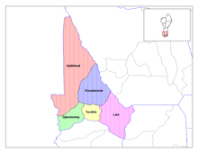
The département of Kouffo was created in 1999 when it was split off from Mono Department and its capital is Aplahoué.[8] Kouffo is subdivided into six communes, each centered at one of the principal towns, namely, Aplahoué, Djakotomey, Klouékanmè, Lalo, Toviklin and Dogbo-Tota.[9] Benin, formerly known as Dahomey, was a French colony till 1894. It gained independence during 1960 and was admitted to the United Nations. From 1960 to 1972, there was political instability with frequent change of leadership.[10] Benin originally had six administrative divisions, but was further bifurcated to make it 12. Each de-concentrated administrative services, called directions départementales(DD) of the sectoral ministries, take care of two administrative regions. A law passed during 1999 empowered the territorial administration to local governments.[9] Municipalities and communal councils have elected representatives who manage the administration of the regions. The latest elections of the municipal and communal councils were held during June 2015.[11]
References
- ↑ Benin at geohive.com
- ↑ Benin Mineral & Mining Sector Investment and Business Guide. Int'l Business Publications. 2007. pp. 21–22. ISBN 9781433019012.
- ↑ McColl, R. W. (2014). Encyclopedia of World Geography, Volume 1. Infobase Publishing. p. 92-93. ISBN 9780816072293.
- ↑ Monroe, J. Cameron (2014). The Precolonial State in West Africa: Building Power in Dahomey. Cambridge University Press. p. 28-30. ISBN 9781107040182.
- ↑ Haggett, Peter, ed. (2002). Encyclopedia of World Geography, Volume 17. Marshall Cavendish. p. 2325. ISBN 9780761473060.
- 1 2 "Socio economic data of Benin, 2013". Institut National de la Statistique et de l’Analyse Economique (INSAE) du Benin. 2013. Retrieved 25 November 2016.
- ↑ "Census of Benin, 2013". Institut National de la Statistique et de l’Analyse Economique (INSAE) du Benin. 2013. Retrieved 25 November 2016.
- ↑ Houngnikpo, Mathurin C.; Decalo, Samuel (2013). Historical Dictionary of Benin. Rowman & Littlefield. p. 29. ISBN 9780810871717.
- 1 2 Republic of Benin, Public Administration and Country profile (PDF) (Report). Department of Economic and Social Affairs (DESA), United Nations. 2004. p. 8. Retrieved 17 November 2016.
- ↑ "Benin country profile". BBC. 5 August 2016. Retrieved 20 November 2016.
- ↑ "Local elections in Benin, 2015". African Elections Database. Retrieved 25 November 2016.