Parakou
| Parakou | |
|---|---|
| Commune and city | |
|
City of Parakou. | |
 Parakou Location in Benin | |
| Coordinates: 9°21′N 2°37′E / 9.350°N 2.617°E | |
| Country | Benin |
| Department | Borgou Department |
| Area | |
| • Total | 441 km2 (170 sq mi) |
| Elevation | 324 m (1,063 ft) |
| Population (2012)[1] | |
| • Total | 206,667 |
| • Density | 470/km2 (1,200/sq mi) |
| Time zone | WAT (UTC+1) |

Parakou is the largest city in eastern Benin, with an estimated population of around 206,667 people, and capital of the Borgou Department. The mayor as of 2008 was Samou Seidou Adambi and administratively the commune of Parakou makes up one of Benin's 77 communes. Since 2015, the mayor is Souradjou Adamou Karimou.
Economy
Parakou lies on the main north-south highway RNIE 2 and at the end of a railway to Cotonou. This has made it an important market town, with major industries in cotton and textiles, peanut oil manufacture and brewing. The town grew initially from revenue generated from passing merchants that took goods from the region across the Sahara and the Mediterranean to Europe. It also served as an important stop over in the distribution of goods around Africa. As a result, Parakou became well known in the slave trade. Later traders concentrated on cotton and Parakou remains the hub of the Beninese cotton trade to this day, with considerable interest from Europe.[2]

There are several markets trading, notably the largest, "Grand Marché Arzeke" which one of the largest in Benin, an international market spanning over a block.[3] The Grand Marché Azeke has a large covered hall overlapping onto the streets with stalls, with 500 and 1000 vendors. The market sells an enormous range of goods from items of pottery including vases and bowls, to cotton textiles, cassettes and CD's of local and international artists, local spices, fruits and Gasaru or wagasi (cow's milk cheese) and even food and kitchen utensils.[4] Another market, located several blocks north, is called the "Marché Kobo Kobo", which lies across the street from the French Cultural Centre. Marché Kobo Kobo is known for its clothing retailing, primarily second hand goods and in one section of it, sells livestock.[5] The Marché Depot is located near Parakou Railway Station around numerous hotels and sells mostly food but also calabashes and baskets. There is also the Marché Guema, located next to Guema Church on the northern road to Malanville in the Albarika quarter of the city. The market was founded by the Somba tribe of the Atacora, and takes place every Sunday at 10 am. The market consists of a collection of grass huts, and specialises in beef and pork and local millet beer known as choukachou or simply "chouk".[4]
Demographics
There is currently a debate about where the name Parakou was derived from. Some people suggests that it derived historically from the word "Kɔrɔku" which designates the baobab tree in Bariba(Baatɔnum)language which is spoken by the majority of the population of the city and its neighboring areas like Tchaourou, N'Dali and Perere. Therefore, the place was called "Kɔrɔku" because of the baobab trees which were predominant in the area and even today you can find some of them around the royal palace of Sinaguruu. Besides, the old people and the Fulani people still use the "Kɔrɔku" for Parakou. Other people say that Parakou is derived from a Dendi word Kparaklu meaning "all the cities" which literally means "the city of everyone", while others again say it derived from the Hausa word "Karuku" which means "centre of the town". Anyhow, the Baruba (Baatɔmbu) were the first settlers and political and administrative rulers of the city and its neighbouring areas before the arrival of the Zarma, Hausa, Yoruba, Manding and Gurmache merchants who were under the polical and economic systems of the predominant Bariba (Baatɔmbu). [4] As a market town frequently attracting many people from different parts of Benin and from other parts of the world including Bariba from other regions such as Nikki and Perere, Dendi, Somba, Fon, (of Gun dialect), Mina, Berba, Djerma, Yoruba (of the Nago tribe), Hausa, Kabrais, Warma, Fula,[6] and Tuareg.[4]
In 1979 the city was reported as having 60,915 people and according to the official census of 1992, Parakou had a population of 103,577. In the last 15–20 years the population of Parakou has nearly doubled with 148,451 recorded in 2002 and with current estimates of 188,853 as of 2009.[7]
Climate
| Climate data for Parakou (1961–1990) | |||||||||||||
|---|---|---|---|---|---|---|---|---|---|---|---|---|---|
| Month | Jan | Feb | Mar | Apr | May | Jun | Jul | Aug | Sep | Oct | Nov | Dec | Year |
| Record high °C (°F) | 36.6 (97.9) |
38.3 (100.9) |
38.9 (102) |
38.4 (101.1) |
35.9 (96.6) |
33.7 (92.7) |
32.1 (89.8) |
31.6 (88.9) |
32.2 (90) |
33.9 (93) |
35.5 (95.9) |
35.8 (96.4) |
38.9 (102) |
| Average high °C (°F) | 34.1 (93.4) |
36.0 (96.8) |
36.2 (97.2) |
34.9 (94.8) |
32.8 (91) |
30.7 (87.3) |
29.2 (84.6) |
28.6 (83.5) |
29.5 (85.1) |
31.5 (88.7) |
33.6 (92.5) |
33.6 (92.5) |
32.6 (90.7) |
| Daily mean °C (°F) | 26.5 (79.7) |
28.7 (83.7) |
29.6 (85.3) |
29.0 (84.2) |
27.5 (81.5) |
26.1 (79) |
25.1 (77.2) |
24.7 (76.5) |
25.0 (77) |
26.1 (79) |
26.6 (79.9) |
26.1 (79) |
26.8 (80.2) |
| Average low °C (°F) | 18.9 (66) |
21.3 (70.3) |
22.9 (73.2) |
23.1 (73.6) |
22.2 (72) |
21.4 (70.5) |
21.0 (69.8) |
20.8 (69.4) |
20.5 (68.9) |
20.8 (69.4) |
19.7 (67.5) |
18.5 (65.3) |
20.9 (69.6) |
| Record low °C (°F) | 15.8 (60.4) |
18.2 (64.8) |
19.9 (67.8) |
19.9 (67.8) |
19.2 (66.6) |
18.9 (66) |
19.0 (66.2) |
19.1 (66.4) |
18.5 (65.3) |
18.6 (65.5) |
16.7 (62.1) |
15.2 (59.4) |
15.2 (59.4) |
| Average precipitation mm (inches) | 3.8 (0.15) |
9.2 (0.362) |
39.4 (1.551) |
85.5 (3.366) |
130.8 (5.15) |
172.0 (6.772) |
189.9 (7.476) |
208.8 (8.22) |
205.6 (8.094) |
91.1 (3.587) |
6.3 (0.248) |
6.6 (0.26) |
1,149 (45.236) |
| Average precipitation days (≥ 1.0 mm) | 0 | 1 | 3 | 5 | 9 | 11 | 12 | 13 | 15 | 7 | 1 | 1 | 78 |
| Source: NOAA[8] | |||||||||||||
Cityscape

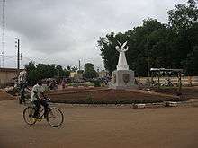
The centre of the city has a roundabout with a distinctive tall pink column emblazoned with the words in red encrypted vertically, "Parakou" .[2] It is located in the central business district surrounding Parakou's banks and administrative buildings. The city has a park but it became extremely polluted with waste and was closed to the public for health concerns.[2] Important banks include the Eco Bank, Bank of Africa and the Financial Bank near Parkou's Le Logos Internet Cafe.[5]
In the city centre there are also the administrative buildings for the government of the commune of Parakou, located opposite the Ministry of Culture, Art and Tourism (open Tuesdays to Saturdays) and Parakou library.[5] Nearby is Parkou police station, post office and taxi/bus station. Up the road from the Bank of Africa there is also the Cinema le Borgou and further north along the road on the opposite side is the French consulate and Hotel les Routiers.[5] The Hotel les Routiers has its own zoo with alligators, turtles, warthogs, a small gazelle, and various birds and the hotel also has works of art for sale including carved wooden masks, wall-hangings and jewelry.[4]

To the south-east of the city, east of the Grand Marché Azeke is a number of health facilities including the Pharmacie Albarika and Parakou Hospital near the Niger consulate. Approximately 1.5 kilometres away from this lies the Musée en Plein Air de Parakou and Motel de Regal in the south.[5]
To the west of the city centre are numerous motels including the Hotel les Triangles, Buffet Hotel and Motel Bravo etc. which are surrounded by a number of travel facilities and Parakou Railway Station.
The Bataclan Nightclub opposite the Hotel Princesse is considered the centre for Parakou's nightlife, particularly at weekends and the nearby KMM club.[9]
Administration
Parakou is one of the 77 official communes of Benin. The mayor of the commune and city as of 2008 is Samou Seidou Adambi.
Villages
The commune of Parakou contains the following villages:[10]
Amawihon, Bakaga, Bakounkparou, Bakounourou, Baperou, Bereyadou, Borarou, Darou Kourarou, Debregourou, Dokparou, Douerou, Forane Kparou, Gagbebou, Ganou, Ga Yakabou, Gommboko, Gorobani, Gouforou, Goutere, Guema, Guererou, Guinrerou, Kaborokpo, Kabro, Karobouarou, Kipare, Konkoma, Koumerou, Kperou Guera, Moundouro, Nekinparo, Nikikperou, Ouroungourou, Pepekino, Pepepeterou, Sanro, Senouorou, Sokoumeno, Sokouno, Sonoumo, Sourou, Suinrou, Tabayorourou, Tankaro, Tankaro Ga, Teougourou Gando, Tian, Tinekonparou, Tora, Tourou, Wansirou, Weria, Wore, Worora, Yakassirou
Religion

There is a mosque in Parakou reflecting a major following of Islam which in fact around half the population follow. The mosque is noted for its fortress-like structure and turrets with dark red window panels. A significant number of the population are Roman Catholic, about a third of the inhabitants, and the city lies within the Roman Catholic Archdiocese of Parakou. It was established on May 13, 1948 as the Apostolic Prefecture of Parakou from the Apostolic Prefecture of Niamey, Niger and from February 10, 1964 promoted as Diocese of Parakou.[11] On October 16, 1997 it formally became the Metropolitan Archdiocese of Parakou. The principal church is the Cathédrale Saints Pierre et Paul.[11] The current archbishop is Fidèle Agbatchi, who was appointed on April 14, 2004.[11]
On February 4, 1993 Pope John Paul II visited the city and had a meeting with representatives of both the Roman Catholic Church and Islam at the "Center d'Alphabétisation Départemental du Borgou" and a mass was held in municipal stadium of Parakou.[12] Ahmadiya Muslim Community inaugurated a mosque in Quartier Titirou, Parakou in April 2004 by his Supreme Head Hadhrat Mirza Masroor Ahmad Sahib Khalifatoul Massih V.
Transport

Parakou Railway Station is the last railway station on the Parakou-Cotonou railway. Both the national highways RNIE 2 and RNIE 6 pass through Parakou. The city is also served by Parakou Airport. The government has proposed extending the railway to Dosso in Niger.[13]
Sport
The main football clubs are Dynamo Unacob FC de Parakou and Buffles du Borgou FC which play in the Benin Premier League, the highest division of Beninese football.
Notable people
- Hubert Maga -First President of Dahomey (the former name of Benin)[14]
See also
References
- ↑ "World Gazetteer". World Gazetteer. Archived from the original on January 11, 2013. Retrieved 2013-07-27.
- 1 2 3 Butler 2006, p. 187.
- ↑ Butler 2006, p. 192.
- 1 2 3 4 5 "Parakou". Benintourism.com. Retrieved January 10, 2009.
- 1 2 3 4 5 Butler 2006, p. 188.
- ↑ In Fula: Fulɓe; in French: Peul or Peulh.
- ↑ "Benin: largest cities and towns and statistics of their population". World Gazeteer. Retrieved January 10, 2009.
- ↑ "Parakou Climate Normals 1961–1990". National Oceanic and Atmospheric Administration. Retrieved January 13, 2015.
- ↑ Butler 2006, p. 191.
- ↑ "Parakou". Maplandia World Gazeteer. Retrieved January 11, 2009.
- 1 2 3 "Metropolitan Archdiocese of Parakou". G.Catholic.com. Retrieved January 10, 2009.
- ↑ "John Paul II travels". The Vatican. Retrieved January 10, 2009.
- ↑ "EXTENDING FROM BENIN TO NIGER". Railways Africa. Retrieved 2010-10-17.
- ↑ Matthews 1966, p. 139.
Bibliography
| Wikimedia Commons has media related to Parakou. |
- Matthews, Ronald (1966). "African Powder Keg: Revolt and Dissent in Six Emergent Nations". London: The Bodley Head. OCLC 246401461..
- Butler, Stuart (2006). "Benin". Guilford, Connecticut: Bradt Travel Guides, The Globe Pequot Press.
Coordinates: 9°21′N 2°37′E / 9.350°N 2.617°E
