Clarksville Commercial Historic District
|
Clarksville Commercial Historic District | |
 | |
  | |
| Location | Roughly bounded by McConnell St. on the S.; Cherry St. on the N.; Johnson St. on the W.; Spadra Creek on the E., Clarksville, Arkansas |
|---|---|
| Coordinates | 35°28′16″N 93°27′59″W / 35.47111°N 93.46639°WCoordinates: 35°28′16″N 93°27′59″W / 35.47111°N 93.46639°W |
| Area | 0 acres (0 ha) |
| Built | 1935 |
| Architect | Simon, Louis A.; Harralson and Nelson |
| Architectural style | Early Commercial, Classical Revival, Mediterranean Revival |
| NRHP Reference # | 08000816[1] |
| Added to NRHP | March 30, 2009 |
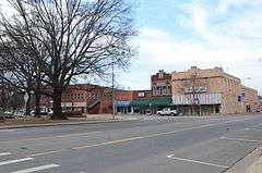
The Clarksville Commercial Historic District encompasses the historic commercial heart of downtown Clarksville, Arkansas. The district extends along Main Street (United States Route 64), from Johnson Street to Union Street, and includes adjacent properties on adjacent cross streets. Although Clarksville was founded in 1836, its downtown area saw its most significant economic development between 1883 and 1958, and it is this era that is reflected in its architecture.[2]
The district was listed on the National Register of Historic Places in 2009.[1] Two properties in the district are also individually listed: the Johnson County Courthouse, and the former station of the Missouri-Pacific Railroad.[2]
See also
References
- 1 2 National Park Service (2010-07-09). "National Register Information System". National Register of Historic Places. National Park Service.
- 1 2 "NRHP nomination for Clarksville Commercial Historic District" (PDF). Arkansas Preservation. Retrieved 2016-05-07.
| Topics | |
|---|---|
| Lists by states |
|
| Lists by insular areas | |
| Lists by associated states | |
| Other areas | |
| |
This article is issued from Wikipedia - version of the 12/2/2016. The text is available under the Creative Commons Attribution/Share Alike but additional terms may apply for the media files.