Civljane
| Civljane Цивљане (Serbian)[1] | |
|---|---|
| Village | |
| Općina Civljane | |
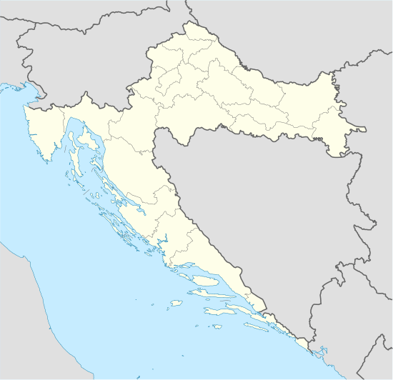 Civljane Location of Civljane in Croatia | |
| Coordinates: 43°57′N 16°24′E / 43.950°N 16.400°E | |
| Country |
|
| County | Šibenik-Knin |
| Government | |
| • Mayor | Ante Gutić (HDZ) |
| Area | |
| • Total | 83.28 km2 (32.15 sq mi) |
| Population (2011) | |
| • Total | 239 |
| Time zone | CET (UTC+1) |
| • Summer (DST) | CEST (UTC+2) |
| Website |
www |
Civljane (Serbian Cyrillic: Цивљане)[2] is a municipality and small village in Šibenik-Knin County, Croatia, with only 239 inhabitants (2011). It is the smallest municipality by population in Croatia.[3]
History
In the 9th century, probably during the time of Duke Branimir of Croatia, the Church of Holy Salvation (Crkva Sv. Spasa) was built in Cetina village, near Vrlika, then called Vrh Rike.[4] It is the only Croatian early medieval church with almost entirely preserved walls.[5]
The Orthodox Church (Hram Vaznesenja) on the spring of the Cetina River was built in 1940, as a foundation of Marko Četnik and his wife Helen. The church was rebuilt in 1974.
Population
As of 2011, there are 188 Serbs, forming 78.7% of the population, and 44 Croats, forming 19.7% of the population, and 7 others.[6] There are 216 Croatian speakers, and 4 Serbian speakers.[7]
The municipality Civljane by the census in 2011 had 239 inhabitants, situated in two villages:[8]
- Cetina - 195
- Civljane - 44
The average age of residents is 71, making Civljane the oldest municipality in Croatia.[9]
Languages
On the territory of Civljane municipality, along with Croatian which is official in the whole country, as a second official language has been introduced Serbian language and Serbian Cyrillic alphabet.[10][2]
Hamlets
Located in inland Dalmatia, north from the town of Vrlika, on the route between towns of Knin and Vrlika, Civljane village spread on 17.80 km2, on the field near the spring of river Cetina, on altitude of approximate 400 m, just under south base of mountain Dinara. Parts of a settlement are hamlets:
- Čitluk
- Dubrava pod Kozjakom
- Kotluša
- Kozjak
- Marjevci pod Kozjakom
See also
References
- ↑ Government of Croatia (October 2013). "Peto izvješće Republike Hrvatske o primjeni Europske povelje o regionalnim ili manjinskim jezicima" (PDF) (in Croatian). Council of Europe. p. 36. Retrieved 30 November 2016.
- 1 2 "Registar Geografskih Imena Nacionalnih Manjina Republike Hrvatske" (PDF). Nipp.hr. Archived from the original (PDF) on 2013-10-29. Retrieved 2014-02-23.
- ↑ "Zanimljivosti iz popisa stanovništva" (in Croatian). 2 July 2011. Retrieved 8 March 2014.
- ↑ "Srednji vijek". Public.carnet.hr. Retrieved 2014-02-23.
- ↑ http://www.hkv.hr/reportae/lj-krinjar/5655-reportaa-starohrvatska-crkva-svetog-spasa-na-izvoru-rijeke-cetine.html
- ↑ "Population by Ethnicity, by Towns/Municipalities, 2011 Census: County of Šibenik-Knin". Census of Population, Households and Dwellings 2011. Zagreb: Croatian Bureau of Statistics. December 2012.
- ↑ "Population by Mother Tongue, by Towns/Municipalities, 2011 Census: County of Šibenik-Knin". Census of Population, Households and Dwellings 2011. Zagreb: Croatian Bureau of Statistics. December 2012.
- ↑ "Population by Age and Sex, by Settlements, 2011 Census: Civljane". Census of Population, Households and Dwellings 2011. Zagreb: Croatian Bureau of Statistics. December 2012.
- ↑ "Pogledajte gdje u Hrvatskoj žive stari, a gdje mladi". Večernji list (in Croatian). 5 January 2014. Retrieved 25 November 2016.
- ↑ Izvješće o provođenju ustavnog zakona o pravima nacionalnih manjina i o utošku sredstava osiguranih u državnom proračunu Republike Hrvatske za 2008. godinu za potrebe nacionalnih manjina, Zagreb, 2009.
External links
Subdivisions of Šibenik-Knin County | ||
|---|---|---|
| Cities and towns |  | |
| Municipalities | ||
Coordinates: 43°57′N 16°24′E / 43.950°N 16.400°E