Chippewa, Wisconsin
- There is also Chippewa County and Chippewa Falls.
| Chippewa, Wisconsin | |
|---|---|
| Town | |
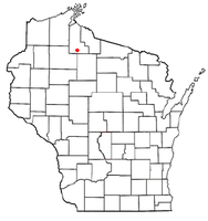 Location of Chippewa, Wisconsin | |
| Coordinates: 46°1′47″N 90°42′30″W / 46.02972°N 90.70833°WCoordinates: 46°1′47″N 90°42′30″W / 46.02972°N 90.70833°W | |
| Country | United States |
| State | Wisconsin |
| County | Ashland |
| Area | |
| • Total | 125.5 sq mi (325.1 km2) |
| • Land | 124.5 sq mi (322.4 km2) |
| • Water | 1.0 sq mi (2.7 km2) |
| Elevation[1] | 1,512 ft (461 m) |
| Population (2010) | |
| • Total | 374 |
| • Density | 3/sq mi (1.2/km2) |
| Time zone | Central (CST) (UTC-6) |
| • Summer (DST) | CDT (UTC-5) |
| Area code(s) | 715 & 534 |
| FIPS code | 55-14550[2] |
| GNIS feature ID | 1582957[1] |
Chippewa is a town in Ashland County in the U.S. state of Wisconsin. The population was 374 at the 2010 census.[3]
Geography
According to the United States Census Bureau, the town has a total area of 125.5 square miles (325.1 km2), of which 124.5 square miles (322.4 km2) is land and 1.0 square mile (2.7 km2), or 0.83%, is water.[3]
Demographics
As of the census[2] of 2000, there were 433 people, 156 households, and 122 families residing in the town. The population density was 3.5 people per square mile (1.3/km²). There were 280 housing units at an average density of 2.3 per square mile (0.9/km²). The racial makeup of the town was 98.15% White, 0.92% African American, 0.69% Native American, and 0.23% from two or more races. Hispanic or Latino of any race were 0.23% of the population.
There were 156 households out of which 28.8% had children under the age of 18 living with them, 69.2% were married couples living together, 5.1% had a female householder with no husband present, and 21.2% were non-families. 18.6% of all households were made up of individuals and 11.5% had someone living alone who was 65 years of age or older. The average household size was 2.72 and the average family size was 3.10.
In the town the population was spread out with 27.9% under the age of 18, 3.9% from 18 to 24, 26.6% from 25 to 44, 23.8% from 45 to 64, and 17.8% who were 65 years of age or older. The median age was 40 years. For every 100 females there were 107.2 males. For every 100 females age 18 and over, there were 113.7 males.
The median income for a household in the town was $42,159, and the median income for a family was $47,250. Males had a median income of $38,750 versus $19,167 for females. The per capita income for the town was $16,841. About 5.3% of families and 8.7% of the population were below the poverty line, including 9.1% of those under age 18 and 2.9% of those age 65 or over.
References
- 1 2 "US Board on Geographic Names". United States Geological Survey. 2007-10-25. Retrieved 2008-01-31.
- 1 2 "American FactFinder". United States Census Bureau. Archived from the original on 2013-09-11. Retrieved 2008-01-31.
- 1 2 "Geographic Identifiers: 2010 Demographic Profile Data (G001): Chippewa town, Ashland County, Wisconsin". U.S. Census Bureau, American Factfinder. Retrieved September 6, 2013.
Municipalities and communities of Ashland County, Wisconsin, United States | ||
|---|---|---|
| Cities | 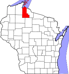 | |
| Village | ||
| Towns | ||
| CDPs | ||
| Unincorporated communities | ||
| Indian reservation | ||
| Footnotes | ‡This populated place also has portions in an adjacent county or counties | |