Chilton, Texas
| Chilton, Texas | |
|---|---|
| Census-designated place | |
|
Featherston Field in Chilton | |
 Chilton  Chilton | |
| Coordinates: 31°16′49″N 97°3′54″W / 31.28028°N 97.06500°WCoordinates: 31°16′49″N 97°3′54″W / 31.28028°N 97.06500°W | |
| Country |
|
| State |
|
| County |
|
| Area | |
| • Total | 3.97 sq mi (10.29 km2) |
| • Land | 3.95 sq mi (10.23 km2) |
| • Water | 0.02 sq mi (0.06 km2) |
| Elevation | 428 ft (130 m) |
| Population (2010) | |
| • Total | 911 |
| • Density | 231/sq mi (89.0/km2) |
| Time zone | Central (CST) (UTC-6) |
| • Summer (DST) | CDT (UTC-5) |
| ZIP code | 76632 |
| Area code(s) | 254 |
| FIPS code | 48-14692[1] |
| GNIS feature ID | 1354403[2] |

Chilton is a census-designated place (CDP) and unincorporated community in Falls County, Texas, United States. It had a population of 911 at the 2010 census.[1]
It is located in western Falls County. U.S. Route 77 forms the western edge of the community, leading north 20 miles (32 km) to Waco and south 16 miles (26 km) to Rosebud. Texas State Highway 7 passes through the center of Chilton, leading east 10 miles (16 km) to Marlin, the county seat, and west 12 miles (19 km) to Bruceville-Eddy.
The Chilton Independent School District offers extra-curricular activities, most notably football, which is played in the stadium at Featherston Field. In 2006, Chilton won its second 1A state football championship.
External links
References
- 1 2 "Geographic Identifiers: 2010 Demographic Profile Data (G001): Chilton CDP, Texas". U.S. Census Bureau, American Factfinder. Retrieved August 22, 2016.
- ↑ U.S. Geological Survey Geographic Names Information System: Chilton, Texas
Municipalities and communities of Falls County, Texas, United States | ||
|---|---|---|
| Cities | 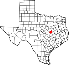 | |
| CDP | ||
| Other unincorporated communities | ||
| Ghost towns | ||
| Footnotes | ‡This populated place also has portions in an adjacent county or counties | |
This article is issued from Wikipedia - version of the 9/4/2016. The text is available under the Creative Commons Attribution/Share Alike but additional terms may apply for the media files.