Chestnut Hill (MBTA station)
CHESTNUT HILL | |||||||||||
|---|---|---|---|---|---|---|---|---|---|---|---|
 Platforms at Chestnut Hill station | |||||||||||
| Location |
Hammond Street and Middlesex Road Chestnut Hill, MA | ||||||||||
| Coordinates | 42°19′37″N 71°9′53″W / 42.32694°N 71.16472°WCoordinates: 42°19′37″N 71°9′53″W / 42.32694°N 71.16472°W | ||||||||||
| Owned by | Massachusetts Bay Transportation Authority | ||||||||||
| Line(s) | |||||||||||
| Platforms | 2 side platforms | ||||||||||
| Tracks | 2 | ||||||||||
| Construction | |||||||||||
| Parking | Yes | ||||||||||
| Bicycle facilities | Yes | ||||||||||
| History | |||||||||||
| Opened | July 4, 1959[1] | ||||||||||
| Traffic | |||||||||||
| Passengers (2009 daily) | 778[2] | ||||||||||
| Services | |||||||||||
| |||||||||||
Chestnut Hill is a stop on the MBTA Green Line "D" Branch, located off Hammond Street north of Massachusetts Route 9 in the Chestnut Hill neighborhood of Newton, Massachusetts. The station has two side platforms serving the line's two tracks. Chestnut Hill station is not handicapped accessible.
Station layout
| G Street/ Platform level |
Side platform, doors will open on the right | |
| Outbound | ← "D" Branch toward Riverside (Newton Center) | |
| Inbound | → "D" Branch toward Government Center (Reservoir) → | |
| Side platform, doors will open on the right | ||
History
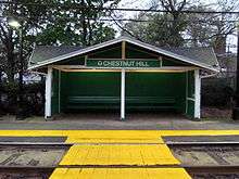
The original Chestnut Hill station opened in 1852 on the Highland Branch, which at the time was a conventional commuter rail line. After 1886, loop service was run via what is now the Framingham/Worcester Line and later the Needham Line. The final trains on the line ran on May 31, 1958. The line was converted to light rail by the M.T.A. and Chestnut Hill reopened on July 4, 1959, along with the rest of the "D" branch.[1] The original stone station was torn down and replaced by a small wooden shelter on the inbound platform.
Bus connections
The station is not directly served by any MBTA bus route. However, the 60 Chestnut Hill - Kenmore Station via Brookline Village & Cypress Street route stops at Boylston Street and Hammond Street, about 500 feet (150 m) to the south.
References
- 1 2 Belcher, Jonathan (23 April 2012). "Changes to Transit Service in the MBTA district" (PDF). NETransit. Retrieved 5 May 2012.
- ↑ "Ridership and Service Statistics" (PDF). Massachusetts Bay Transportation Authority. 2010. Retrieved 5 May 2012.
External links
- MBTA - Chestnut Hill Station
-
 Media related to Chestnut Hill (MBTA station) at Wikimedia Commons
 - Hammond Street entrance from Google Maps Street View