Chedzoy

Coordinates: 51°08′02″N 2°57′04″W / 51.134°N 2.951°W
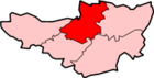
Chedzoy is a civil parish village 3 miles (4.8 km) east of Bridgwater in the Sedgemoor district of Somerset, England.
History
The village is at the western end of King's Sedgemoor and lies on an 'island' of Burtle marine sands, close to King's Sedgemoor Drain. The area was settled possibly in the Mesolithic period, and timber trackways from the 3rd to 1st millennium B.C. provided routes to other settlements on the Somerset Levels. Roman artifacts have been found in the parish.[2][3]
The village is very close to the site of the Battle of Sedgemoor in 1685.
The name of the village is pronounced "Chidgey" or "Chedzey",[4] and derives its name from being Cedd's Island.[5] The "zoy" part of the name being derived from eg or ieg meaning island.[6]
Governance
The parish council has responsibility for local issues, including setting an annual precept (local rate) to cover the council’s operating costs and producing annual accounts for public scrutiny. The parish council evaluates local planning applications and works with the local police, district council officers, and neighbourhood watch groups on matters of crime, security, and traffic. The parish council's role also includes initiating projects for the maintenance and repair of parish facilities, as well as consulting with the district council on the maintenance, repair, and improvement of highways, drainage, footpaths, public transport, and street cleaning. Conservation matters (including trees and listed buildings) and environmental issues are also the responsibility of the council.
The village falls within the Non-metropolitan district of Sedgemoor, which was formed on 1 April 1974 under the Local Government Act 1972, having previously been part of Bridgwater Rural District,[7] which is responsible for local planning and building control, local roads, council housing, environmental health, markets and fairs, refuse collection and recycling, cemeteries and crematoria, leisure services, parks, and tourism.
Somerset County Council is responsible for running the largest and most expensive local services such as education, social services, libraries, main roads, public transport, policing and fire services, trading standards, waste disposal and strategic planning.
It is also part of the Bridgwater and West Somerset county constituency represented in the House of Commons of the Parliament of the United Kingdom. It elects one Member of Parliament (MP) by the first past the post system of election, and part of the South West England constituency of the European Parliament which elects seven MEPs using the d'Hondt method of party-list proportional representation.
Religious sites
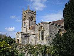
The church of St Mary dates from the 13th century and has been designated by English Heritage as a grade I listed building.[8] It still bears marks from the forces of The Duke of Monmouth during the Monmouth Rebellion who sharpened their swords before battle.[9]
References
- ↑ "Statistics for Wards, LSOAs and Parishes — SUMMARY Profiles" (Excel). Somerset Intelligence. Retrieved 4 January 2014.
- ↑ "Chedzoy". British History Online. Retrieved 2007-12-06.
- ↑ Havinden, Michael. The Somerset Landscape. The making of the English landscape. London: Hodder and Stoughton. p. 74. ISBN 0-340-20116-9.
- ↑ Plea Rolls of the Court of Common Pleas; CP 40/541; year 1396; http://aalt.law.uh.edu/AALT6/R2/CP40no541a/bCP40no541adorses/IMG_0037.htm, seen as 'Chedesye'; third entry
- ↑ Ekwall, Eilert (1960). The concise dictionary of English place-names. Oxford: Oxford University Press. p. 99. ISBN 0198691033.
- ↑ R W Dunning, C R Elrington (Editors), A P Baggs, M C Siraut (1992). "Chedzoy". A History of the County of Somerset: Volume 6: Andersfield, Cannington, and North Petherton Hundreds (Bridgwater and neighbouring parishes). Institute of Historical Research. Retrieved 28 December 2012.
- ↑ "Brdigwater RD". A vision of Britain Through Time. University of Portsmouth. Retrieved 4 January 2014.
- ↑ "Church of St Mary". Images of England. Retrieved 2007-12-06.
- ↑ Leete-Hodge, Lornie (1985). Curiosities of Somerset. Bodmin: Bossiney Books. p. 81. ISBN 0-906456-98-3.
External links
| Wikimedia Commons has media related to Chedzoy. |
- St. Mary's Church, Chedzoy website
- Chedzoy Parish Council website
- Conservation of Chedzoy Church Tower article