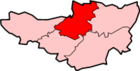
Bawdrip
| Bawdrip | |
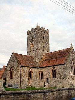 St Michael and All Angels Church, Bawdrip |
|
 Bawdrip |
|
| Population | 506 [1] |
|---|---|
| OS grid reference | ST340395 |
| District | Sedgemoor |
| Shire county | Somerset |
| Region | South West |
| Country | England |
| Sovereign state | United Kingdom |
| Post town | BRIDGWATER |
| Postcode district | TA7 |
| Dialling code | 01278 |
| Police | Avon and Somerset |
| Fire | Devon and Somerset |
| Ambulance | South Western |
| EU Parliament | South West England |
| UK Parliament | Bridgwater and West Somerset |
Coordinates: 51°09′04″N 2°56′38″W / 51.151°N 2.944°W
Bawdrip is a village and civil parish in the Sedgemoor district of Somerset, England. The village is on the south side of the Polden Hills about 4 miles (6.4 km) north-east of Bridgwater. According to the 2011 census the parish had a population of 506.[1] The parish includes the hamlets of Bradney and Horsey. The name Horsey comes from Anglo-Saxon "hors-eg" and means 'horse island' and was mentioned in the Domesday Book.
History
There may have been quarrying on the hillside in the 15th century and lias was dug in the early 19th. Lime was being extracted and processed in the extreme western tip of the parish under Puriton Hill by 1886 and until 1973 in association with the cement works at Dunball. Salt was extracted in the early 20th century.[2]
The small building on Church Road, sometimes known as "The Dwarf's House" dates from the early 19th century.[3] It is 13 feet (4.0 m) by 9 feet (2.7 m) and 13 feet (4.0 m) high.[4]
King's Sedgemoor Drain crosses the parish from south-east to north-west.
Governance
The parish council has responsibility for local issues, including setting an annual precept (local rate) to cover the council’s operating costs and producing annual accounts for public scrutiny. The parish council evaluates local planning applications and works with the local police, district council officers, and neighbourhood watch groups on matters of crime, security, and traffic. The parish council's role also includes initiating projects for the maintenance and repair of parish facilities, as well as consulting with the district council on the maintenance, repair, and improvement of highways, drainage, footpaths, public transport, and street cleaning. Conservation matters (including trees and listed buildings) and environmental issues are also the responsibility of the council.
The village falls within the Non-metropolitan district of Sedgemoor, which was formed on 1 April 1974 under the Local Government Act 1972, having previously been part of Bridgwater Rural District,[5] which is responsible for local planning and building control, local roads, council housing, environmental health, markets and fairs, refuse collection and recycling, cemeteries and crematoria, leisure services, parks, and tourism.
Somerset County Council is responsible for running the largest and most expensive local services such as education, social services, libraries, main roads, public transport, policing and fire services, trading standards, waste disposal and strategic planning.
It is also part of the Bridgwater and West Somerset county constituency represented in the House of Commons of the Parliament of the United Kingdom. It elects one Member of Parliament (MP) by the first past the post system of election, and part of the South West England constituency of the European Parliament which elects seven MEPs using the d'Hondt method of party-list proportional representation.
Transport
Bawdrip lies just off the A39 approximately 2 miles (3.2 km) from its junction with the M5 motorway.
It formerly had a railway station, Bawdrip Halt on the Somerset and Dorset Joint Railway, giving rail access to Bridgwater and Glastonbury; the halt opened in 1923 and closed in 1951.
Religious sites
The Church of St Michael and All Angels dates predominantly form the late 13th and early 14th century, but underwent extensive restoration in 1866.[6] The nearby 19th century rectory[7] has been suggested as one of the sites for the Legend of the Mistletoe Bough.
Education
Kingsmoor Primary School is located within Bawdrip Central Business District, on Church road. The school has approximately 150 pupils at any one time, six classrooms, outdoor space including a partial climbing wall and play equipment, and wooden shelters against the sun and rain.
The village is in the catchment area for East Bridgwater Community School in Eastover (formally known as the secondary modern, Sydenham), and most of the houses are far enough away to qualify for free bus transport.
References
- 1 2 "Statistics for Wards, LSOAs and Parishes — SUMMARY Profiles" (Excel). Somerset Intelligence. Retrieved 4 January 2014.
- ↑ "Bawdrip". Victoria County History. British History Online. Retrieved 25 November 2008.
- ↑ "Small House immediately east of Kingsmoor House". Images of England. English Heritage. Retrieved 20 March 2011.
- ↑ Warren, Derrick (2005). Curious Somerset. Stroud: Sutton Publishing. p. 23. ISBN 978-0-7509-4057-3.
- ↑ "Brdigwater RD". A vision of Britain Through Time. University of Portsmouth. Retrieved 4 January 2014.
- ↑ "Church of St Michael and All Angels". Images of England. English Heritage. Retrieved 25 November 2008.
- ↑ "The rectory". Images of England. English Heritage. Retrieved 25 November 2008.
External links
| Wikimedia Commons has media related to Bawdrip. |