Cerro Pantoja
| Cerro Pantoja | |
|---|---|
 | |
| Highest point | |
| Elevation | 2,024 m (6,640 ft) |
| Coordinates | 40°46′0″S 71°57′0″W / 40.76667°S 71.95000°WCoordinates: 40°46′0″S 71°57′0″W / 40.76667°S 71.95000°W |
| Geography | |
| Location | Argentina/Chile |
| Parent range | Andes |
| Geology | |
| Mountain type | Stratovolcano |
| Last eruption | Unknown |
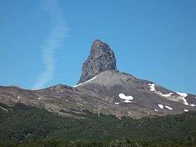
Cerro Pantoja, also spelled as Cerro Pantojo, is an extinct basaltic stratovolcano on the border of Argentina and Chile. It lies immediately south of Cardenal Antonio Samoré Pass and its characteristic spire-shaped summit is an eroded volcanic plug. It also has flank lava flows.
See also
References
- "Cerro Pantoja". Global Volcanism Program. Smithsonian Institution.
- Lara, Luis; Rodríguez, Carolina; Moreno, Hugo; Pérez de Arce, Carlos (July 2001). "Geocronología K-Ar y geoquímica del volcanismo plioceno superior-pleistoceno de los Andes del sur (39-42°S)". Revista geológica de Chile (in Spanish). Santiago: SciELO. 28 (1). doi:10.4067/S0716-02082001000100004. ISSN 0716-0208. Retrieved 24 September 2015.
This article is issued from Wikipedia - version of the 11/24/2016. The text is available under the Creative Commons Attribution/Share Alike but additional terms may apply for the media files.