Centreville Historic District (Centreville, Maryland)
|
Centreville Historic District | |
|
Queen Anne's County courthouse, October 2007 | |
  | |
| Location | Roughly bounded by Corsica R, Chesterfield Ave, Liberty St, Banio Ln,Railroad Ave, town limits and Mill Stream, Centreville, Maryland |
|---|---|
| Coordinates | 39°2′45″N 76°4′2″W / 39.04583°N 76.06722°WCoordinates: 39°2′45″N 76°4′2″W / 39.04583°N 76.06722°W |
| Area | 515 acres (208 ha) |
| Built | 1792 |
| Architectural style | Federal, Greek Revival |
| NRHP Reference # | 04001218[1] |
| Added to NRHP | November 13, 2004 |
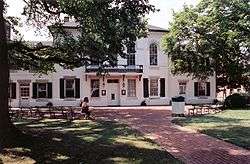
Centreville Historic District is a national historic district at Centreville, Queen Anne's County, Maryland, United States. It contains an exceptional collection of 18th, 19th, and 20th century buildings chronicling the architectural development of an Eastern Shore of Maryland community. Among Centreville's residential, commercial, and ecclesiastical buildings are representative examples of the various architectural types and styles which characterized towns in the region during the period.[2]
It was added to the National Register of Historic Places in 2004.[1]
References
- 1 2 National Park Service (2010-07-09). "National Register Information System". National Register of Historic Places. National Park Service.
- ↑ unknown (n.d.). "National Register of Historic Places Registration: Centreville Historic District" (PDF). Maryland Historical Trust. Retrieved 2016-03-01.
External links
- Centreville Historic District, Queen Anne's County, including photo from 2003, at Maryland Historical Trust
- Boundary Map of the Centreville Historic District, Queen Anne's County, at Maryland Historical Trust
| Topics |   | |
|---|---|---|
| Lists by county | ||
| Lists by city | ||
| Other lists | ||
| ||
This article is issued from Wikipedia - version of the 11/27/2016. The text is available under the Creative Commons Attribution/Share Alike but additional terms may apply for the media files.