Cato (village), New York
| Cato, New York | |
|---|---|
| Village | |
 Cato Location within the state of New York | |
| Coordinates: 43°10′7″N 76°34′25″W / 43.16861°N 76.57361°WCoordinates: 43°10′7″N 76°34′25″W / 43.16861°N 76.57361°W | |
| Country | United States |
| State | New York |
| County | Cayuga |
| Town | Cato |
| Area | |
| • Total | 1.01 sq mi (2.62 km2) |
| • Land | 0.99 sq mi (2.56 km2) |
| • Water | 0.02 sq mi (0.06 km2) |
| Elevation | 459 ft (140 m) |
| Population (2010) | |
| • Total | 532 |
| • Density | 538/sq mi (207.8/km2) |
| Time zone | Eastern (EST) (UTC-5) |
| • Summer (DST) | EDT (UTC-4) |
| ZIP code | 13033 |
| Area code(s) | 315 |
| FIPS code | 36-12958 |
| GNIS feature ID | 0946053 |
| Website |
villageofcatony |
Cato is a village in Cayuga County, New York, United States. The population was 532 at the 2010 census.[1] The name was assigned by the surveyors of the Military Tract, and is one of many towns and villages bearing classical place names. The village of Cato is half within the town of Cato and half within the town of Ira. It is west of Syracuse.
History
The village was part of the Central New York Military Tract, land set aside in 1782 for veterans of the American Revolution. Prior native occupants were compelled to live on reservations established at that time. The first permanent settler arrived around 1805, and the new community was called "Jakway's Corners".
Railroad service came to the village in 1869, aiding its prosperity, but rail service ended in 1953.
Cato is home to the 1993 Section 3 Class D state football champions. Modern Cato is partly a bedroom community, with many residents commuting to surrounding cities.
Geography
According to the United States Census Bureau, the village has a total area of 1.0 square mile (2.6 km2), of which 0.023 square miles (0.06 km2), or 2.44%, is water.[1]
The village is located in a drumlin field.
Parker Pond, formerly known as "Forest Lake", is a small lake at the southeast edge of the village. Muskrat Creek drains from the lake and flows southward to the Seneca River (and Erie Canal).
The village is at the junction of NY-34 and NY-370. Locating places within the village is extremely simple, since virtually all locations which may be visited by a non-resident are located on these two highways.
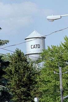
Water tower
The Cato water tower stands 120 feet (37 m) over the village of Cato, to the northeast of the village center. The light blue structure had been a landmark for 75 years or more but was to be torn down as of June 2012. The new water tower was to be dark blue on top and still say "Cato" on both sides. It will sit on 82 feet (25 m) of concrete. It will also be bigger, holding 25,000 extra gallons of water, in anticipation of future town growth.
Demographics
| Historical population | |||
|---|---|---|---|
| Census | Pop. | %± | |
| 1880 | 313 | — | |
| 1900 | 350 | — | |
| 1910 | 374 | 6.9% | |
| 1920 | 404 | 8.0% | |
| 1930 | 403 | −0.2% | |
| 1940 | 412 | 2.2% | |
| 1950 | 431 | 4.6% | |
| 1960 | 476 | 10.4% | |
| 1970 | 601 | 26.3% | |
| 1980 | 475 | −21.0% | |
| 1990 | 581 | 22.3% | |
| 2000 | 601 | 3.4% | |
| 2010 | 532 | −11.5% | |
| Est. 2015 | 521 | [2] | −2.1% |
As of the census[4] of 2000, there were 601 people, 238 households, and 154 families residing in the village. The population density was 608.2 people per square mile (234.4/km²). There were 253 housing units at an average density of 256.0 per square mile (98.7/km²). The racial makeup of the village was 97.50% White, 0.33% Black or African American, 0.50% Native American, 0.33% from other races, and 1.33% from two or more races. Hispanic or Latino of any race were 0.50% of the population.
There were 238 households out of which 35.3% had children under the age of 18 living with them, 51.3% were married couples living together, 11.3% had a female householder with no husband present, and 34.9% were non-families. 31.5% of all households were made up of individuals and 19.7% had someone living alone who was 65 years of age or older. The average household size was 2.53 and the average family size was 3.15.
In the village the population was spread out with 29.5% under the age of 18, 6.3% from 18 to 24, 27.8% from 25 to 44, 19.3% from 45 to 64, and 17.1% who were 65 years of age or older. The median age was 38 years. For every 100 females there were 87.8 males. For every 100 females age 18 and over, there were 80.4 males.
The median income for a household in the village was $35,938, and the median income for a family was $49,219. Males had a median income of $37,303 versus $26,250 for females. The per capita income for the village was $17,511. About 2.9% of families and 6.9% of the population were below the poverty line, including 5.5% of those under age 18 and 21.0% of those age 65 or over.
Entertainment and recreation
There are a number of popular attractions in Cato, including the Cato Hotel, Cato Diner/Ice Cream stand, the TC's Bar, Van Nostrand Full Service Gas Station, Terry's Food Mart, and the Cato New York Pizzeria.
References
- 1 2 "Geographic Identifiers: 2010 Demographic Profile Data (G001): Cato village, New York". U.S. Census Bureau, American Factfinder. Retrieved November 14, 2014.
- ↑ "Annual Estimates of the Resident Population for Incorporated Places: April 1, 2010 to July 1, 2015". Retrieved July 2, 2016.
- ↑ "Census of Population and Housing". Census.gov. Archived from the original on May 11, 2015. Retrieved June 4, 2015.
- ↑ "American FactFinder". United States Census Bureau. Archived from the original on 2013-09-11. Retrieved 2008-01-31.
External links
Municipalities and communities of Cayuga County, New York, United States | ||
|---|---|---|
| City | 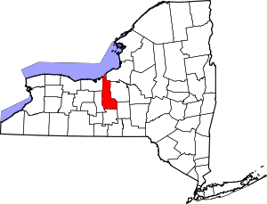 | |
| Towns | ||
| Villages | ||
| CDP | ||
| Other hamlets | ||
| Footnotes | ‡This populated place also has portions in an adjacent county or counties | |