Cartier (Montreal Metro)
Cartier | |||||||||||
|---|---|---|---|---|---|---|---|---|---|---|---|
 | |||||||||||
| Location |
5, boulevard Cartier Ouest, Laval Quebec, Canada | ||||||||||
| Coordinates | 45°33′37″N 73°40′55″W / 45.56028°N 73.68194°WCoordinates: 45°33′37″N 73°40′55″W / 45.56028°N 73.68194°W | ||||||||||
| Operated by | Société de transport de Montréal | ||||||||||
| Connections | See Terminus Cartier | ||||||||||
| Construction | |||||||||||
| Architect | Richard Fortin | ||||||||||
| History | |||||||||||
| Opened | 26 April 2007 | ||||||||||
| Services | |||||||||||
| |||||||||||
Cartier is a station on the Orange Line of the Montreal Metro rapid transit system, operated by the Société de transport de Montréal (STM). It is located in the Pont-Viau district of Laval, Quebec, Canada.[1] It is part of an extension of the line into Laval and opened on April 28, 2007.
Architecture
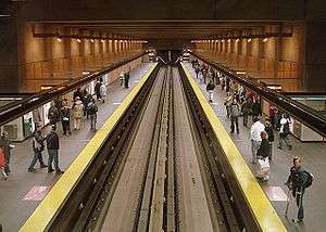
It is a normal side platform station. The station's main entrance, adjoining the bus terminal, takes the form of a right triangle, with the legs parallel to the streets and the hypotenuse parallel to the tracks, thereby bringing the aboveground and underground world into relation. There is an entrance at each of the two points of the triangle, while the centre is sunken to provide access to the escalators to the ticket hall and to the tunnel to the secondary entrance. The sunken area looks out onto a sunken garden.
A second entrance on the opposite corner of Boul. des Laurentides and Av. Cartier, to spare pedestrians from crossing the busy boulevard, was opened on May 22, 2009.[2]
The station features two artworks. The first, L'Homme est un roseau pensant III by Jacek Jarnuszkiewicz, is a pair of tall, slender metal spires on the edge of the garden. The second, Dessins suspendus by Yvon Proulx, is installed in the secondary entrance.
Origin of name
The station is named for nearby Boulevard Cartier, which in turn was named for George-Étienne Cartier, a French-Canadian statesman and Father of Confederation.
Nearby points of interest
- Cartier arena (Laval-des-Rapides)
- Cartier park (Laval-des-Rapides)
- Du Marigot park (Pont-Viau)
- Laval Municipal court (Pont-Viau)
- Ahuntsic Bridge
Terminus Cartier
Terminus Cartier | |
|---|---|
| Location | 44, boul. des Laurentides, Laval[3] |
| Coordinates | 45°33′36″N 73°40′54″W / 45.56000°N 73.68167°W |
| Owned by | AMT |
| Line(s) | |
| Construction | |
| Parking | 599 park and ride spaces[3] |
| Bicycle facilities | 54 places in racks[3] |
| Other information | |
| Website | Terminus Cartier |
| Traffic | |
| Passengers (2014[4]) | 4,788,000 |
A large bus terminal with 11 platforms and two park and ride lots (599 free spaces[3] ) has been built above the subway station. The covered bus terminal has an Agence métropolitaine de transport (AMT) ticket counter, a heated waiting area, and electronic boards to display bus departures. In addition, a shopping concourse has been built adjacent to the bus terminal to eventually welcome shops and restaurants. A convenience store and a café are currently the only tenants.
Connecting bus routes
| Société de transport de Laval (STL) | |
|---|---|
| No.[5] | Route[6] |
| 2 | Henri-Bourassa - Montmorency |
| 12 | Pont-Viau - Métro Cartier |
| 17 | Auteuil - Métro Cartier |
| 20 | Chomedey - Métro Cartier |
| 24 | Sainte-Dorothée - Métro Cartier |
| 25 | Saint-François - Métro Cartier |
| 27 | Vimont - Métro Cartier |
| 28 | Saint-Vincent-de-Paul - Métro Cartier |
| 31 | Auteuil - Métro Henri-Bourassa |
| 33 | Métro Montmorency - Métro Cartier |
| 37 | Chomedey - Métro Cartier |
| 41 | Auteuil - Métro Cartier |
| 43 | Auteuil - Métro Cartier |
| 48 | Duvernay - Métro Cartier |
| 58 | Saint-Vincent-de-Paul - Métro Cartier |
| 60 | Chomedey - Métro Cartier |
| 63 | Gare Sainte-Rose - Métro Cartier |
| 70 | Métro Montmorency - Métro Cartier |
| 73 | Fabreville - Métro Cartier |
| 74 | Saint-François - Métro Cartier |
| 901 | Saint-François - Métro Cartier |
| CIT Laurentides | |
| No.[5] | Route |
| 24 | Sainte-Anne-des-Plaines - Laval |
| 28 | Bois-des-Filion - Laval |
| Inter city bus routes | |
| Orléans Express, Groupe Galland and Autobus Maheux provide intercity bus services to the terminus.[5] Expedibus courier and shipping services are also available.[7] | |
See also
References
- ↑ Cartier Metro Station
- ↑ Cartier station
- 1 2 3 4 AMT Terminus Cartier page
- ↑ Ridership from Rapport annuel 2014 [Annual Report 2014] (PDF). amt.qc.ca (Report) (in French). Montreal: Agence métropolitaine de transport [Metropolitan Transportation Agency]. ISBN 978-2-550-72933-4.
- 1 2 3 AMT Plan of Terminus Cartier Archived December 9, 2011, at the Wayback Machine.
- ↑ STL stops and routes: Métro Cartier
- ↑ Expedibus: Montréal Region
External links
- Cartier Station - Official STM web page (French)
- Montreal by Metro, metrodemontreal.com
- STL Schedules
- STL 2011 map (French)
- STM 2011 System map