Laval-des-Rapides
For other uses, see Laval-des-Rapides (disambiguation).
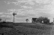
Farm in Laval-des-Rapides in 1941
Laval-des-Rapides is a district in Laval, Quebec, Canada. It was a separate city until the municipal mergers on August 6, 1965.
Geography
The neighbourhood is delimited on the north, north-west and west by Chomedey, on the east and north-east by Pont-Viau and on the south by the Rivière des Prairies.[1]
References
- ↑ Interactive map of Laval from the official website Shows both the borders and names of the 14 former municipalities (purple) and the borders only of the current 6 sectors (maroon), tick off both boxes beside "Limite administrative".
External links
| Neighbourhoods | |||
|---|---|---|---|
| Administration | |||
| Public services | |||
| Education |
| ||
| Other | |||
| |||
Coordinates: 45°33′N 73°42′W / 45.550°N 73.700°W
This article is issued from Wikipedia - version of the 9/2/2014. The text is available under the Creative Commons Attribution/Share Alike but additional terms may apply for the media files.