Plamondon (Montreal Metro)
Plamondon | |||||||||||
|---|---|---|---|---|---|---|---|---|---|---|---|
 | |||||||||||
| Location |
4811, av. Plamondon & 6250, av. Victoria, Montreal Quebec, Canada | ||||||||||
| Coordinates | 45°29′44″N 73°38′26″W / 45.49556°N 73.64056°WCoordinates: 45°29′44″N 73°38′26″W / 45.49556°N 73.64056°W | ||||||||||
| Operated by | Société de transport de Montréal | ||||||||||
| Connections | |||||||||||
| Construction | |||||||||||
| Depth | 23.8 metres (78 feet 1 inch), 8th deepest | ||||||||||
| Architect | Patrice Gauthier | ||||||||||
| History | |||||||||||
| Opened | 29 June 1982 | ||||||||||
| Traffic | |||||||||||
| Passengers | 3,538,492 entrances in 2006, 25th of 68 | ||||||||||
| Services | |||||||||||
| |||||||||||
Plamondon is a station on Orange Line of the Montreal Metro rapid transit system, operated by the Société de transport de Montréal (STM). It is located in the Côte-des-Neiges section of the borough of Côte-des-Neiges–Notre-Dame-de-Grâce in Montreal, Quebec, Canada.[1]
The station opened on June 29, 1982; it served as the western terminus of the Orange Line, replacing Côte-Sainte-Catherine station, until the extension to Du Collège was completed in 1984.
Overview
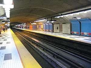
The station is a normal side platform station with an entrance at either end. The northern entrance is integrated into a social housing project at the corner of Avenue Plamondon and Victoria Avenue. The southern entrance is located on the corner of Van Horne avenue and Victoria avenue near a commercial center and an elementary school. The station decor is divided in two to reflect the two entrances, with blue panels to the north and reddish-pink to the south.
The station was designed by Patrice Gauthier.
Origin of the name
This station is named for av. Plamondon, so named by Montreal city council in 1911 without a stated reason. It may be named for Quebec painter Antoine Plamondon (1804–1895) or singer Rodolphe Plamondon[2] (1875–1940).
Connecting bus routes
| Société de transport de Montréal | |||
|---|---|---|---|
| Route | Service Times | Map | Schedule |
| |
All-day | Map | Schedule |
| |
All-day | Map | Schedule |
| |
All-day | Map | Schedule |
| |
Overnight | Map | Schedule |
| |
Overnight | Map | Schedule |
Nearby points of interest
- Marche Victoria
- Académie Shadd
- Collège rabbinique du Canada
- Parc Nelson-Mandela
- Centre commercial Van Horne
- Loisirs Sportifs Cote-Des-Neiges
References
External links
- Plamondon Station - official web page
- Plamondon metro station geo location
- Montreal by Metro, metrodemontreal.com
- 2011 STM System Map
- Metro Map