Two Lights State Park
Two Lights State Park is a publicly owned recreation area named after the twin Cape Elizabeth Lights on Cape Elizabeth, Maine.[3] The 41-acre (17 ha) state park opened in 1961 and offers views of Casco Bay and the Atlantic Ocean. In addition to rocky headlands, the park includes the remains of a World War II-era seacoast battery bunker and a fire control tower. Note there are no lighthouses in the park itself.
History
Maritime
The nearby twin lighthouses were built in 1828, but cannot be viewed from this park. The easternmost light is still active; the other was decommissioned in 1924, served as a fire control tower in World War II, and is now a private home. Although the lighthouses cannot be seen from within the park, they can be viewed from a turnaround at the end of Two Lights Road. Edward Hopper made one of the towers the subject of his 1929 painting The Lighthouse at Two Lights,[4] which was used on a U.S. postage stamp in 1970 commemorating the sesquicentennial of Maine statehood.[5]
Military
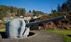
During World War II, the park area was the Cape Elizabeth Military Reservation. The coast defense battery in the park was Battery Construction Number (BCN) 201, designed for two 6-inch guns in shielded mounts that would be on the large concrete circles at each end of the bunker. As of 2016 an interpretive plaque on one of the gun positions shows the internal arrangement of the bunker. However, with the threat from surface ships nearly non-existent by the time the battery was completed, it was not armed. It was part of a modernization of the Harbor Defenses of Portland, centered on Battery Steele on Peaks Island. A duplicate of Battery Steele, BCN 101 with two 16-inch guns, was planned for an area near the park but never built.[6][7][8]
Activities and amenities
The park offers a network of paths of nearly two miles, traversing both forested lands and seaside rock ledges.[9] Facilities include benches along the shore, restrooms, playground, and picnic tables.[3]
References
- 1 2 "Two Lights State Park". Geographic Names Information System. United States Geological Survey.
- ↑ "Outdoors in Maine: State Parks, Public Lands, and Historic Sites" (PDF). Department of Agriculture, Conservation and Forestry. Retrieved December 9, 2015.
- 1 2 "Two Lights State Park". Department of Agriculture, Conservation and Forestry. Retrieved July 25, 2014.
- ↑ "The Lighthouse at Two Lights". The Collection Online. The Metropolitan Museum of Art. Retrieved July 25, 2014.
- ↑ "Cape Elizabeth West". Lighthousefriends. Retrieved December 9, 2015.
- ↑ Berhow, Mark A., ed. (2004). American Seacoast Defenses, A Reference Guide, Second Edition. CDSG Press. p. 203. ISBN 0-9748167-0-1.
- ↑ "Fort and Battery List". Coastal Defense Study Group. Retrieved September 22, 2015.
- ↑ "Cape Elizabeth Military Reservation". FortWiki. Retrieved September 22, 2015.
- ↑ "Two Lights State Park". Maine Trail Finder. Center for Community GIS. Retrieved December 9, 2015.
External links
|
|---|
|
| Army | | |
|---|
|
| Air Force | |
|---|
|
| Navy | | Naval Air Station | |
|---|
| | Radio Station | |
|---|
| | Shipyard | |
|---|
| | Prison | |
|---|
|
|---|
|
| Coast Guard | | Station |
- Caribou
- Eastport
- Jonesport
- Rockland
- South Portland
|
|---|
|
|---|
|
| National Guard | | Air National Guard Base | |
|---|
| | Air National Guard Station | |
|---|
| | Army National Guard Camp | |
|---|
| | Army National Guard Armory |
- Bangor
- Belfast
- Calais
- Caribou
- Fort Kent
- Gardiner
- Houlton
- Lewiston
- Norway
- Portland
- Sanford
- Skowhegan
- Waterville
- Westbrook
|
|---|
|
|---|