Camp Release State Monument
|
Camp Release State Monument | |
|
Camp Release State Monument | |
  | |
| Nearest city | Montevideo, Minnesota |
|---|---|
| Coordinates | 44°56′8″N 95°44′50″W / 44.93556°N 95.74722°WCoordinates: 44°56′8″N 95°44′50″W / 44.93556°N 95.74722°W |
| Built | 1862 |
| NRHP Reference # | 73000981[1] |
| Added to NRHP | March 14, 1973 |
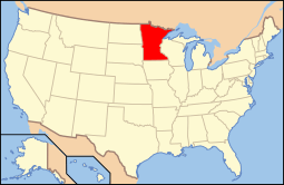
Camp Release State Monument is located on the edge of Montevideo, Minnesota, United States, just off Highway 212. The Camp Release Monument stands as a reminder of Minnesota's early state history. The Minnesota River Valley and Montevideo played an integral part in the Dakota War of 1862. In the fall of 1862, the Dakota tribes surrendered to Colonel Henry Hastings Sibley on a bluff overlooking the valley and the present day site of Montevideo. The monument was the first property added to the state park system and was listed on the National Register of Historic Places in 1973.
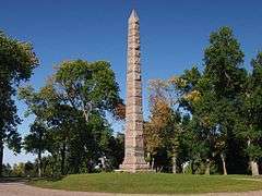
The monument is located in the 6 acre Camp Release State Memorial Wayside.[2]
Camp Release dedication
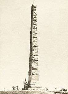
The Camp Release Monument was dedicated on July 4, 1894, commemorating the release of 269 captives and the surrender of about 1200 Dakota people at the end of the conflict. The four faces of the 51-foot granite monument are inscribed with information about the battles that took place along the Minnesota River during the conflict, the Dakota's surrender, and the creation of the monument.
See also
References
- ↑ National Park Service (2006-03-15). "National Register Information System". National Register of Historic Places. National Park Service.
- ↑ http://www.dot.state.mn.us/roadsides/historic/files/iforms/LP-CAM-003.pdf MNDOT Historic Roadside Development Structures Inventory