Camden to Washington Road-Rosston Segment
|
Camden to Washington Road-Rosston Segment | |
 | |
  | |
| Nearest city | Rosston, Arkansas |
|---|---|
| Coordinates | 33°35′30″N 93°10′08″W / 33.5917°N 93.1690°WCoordinates: 33°35′30″N 93°10′08″W / 33.5917°N 93.1690°W |
| Area | 15.15 acres (6.13 ha) |
| Built | 1825 |
| NRHP Reference # | 08001374[1] |
| Added to NRHP | January 29, 2009 |
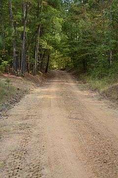
The Camden to Washington Road-Rosston Segment is a historic early 19th-century road section in rural Nevada County, Arkansas. It is located east of Rosston in Poison Spring State Forest, and is a former portion of County Road 10 extending east from that road's junction with County Road 47 (Kirk Road). The road was first cut c. 1825, and was never paved or given modern finishing, despite its continued use well into the 20th century. A crossing at Cypress Creek has been compromised by the activities of beavers, and the road is no longer completely passable, possibly excepting high-clearance off-road vehicles. The road section is the one of the only sections of the historic post road which connected Washington and Camden to retain its 19th-century character.[2]
The road section was listed on the National Register of Historic Places in 2009.[1] The Carolina Methodist Church is located on this section of road.
See also
References
- 1 2 National Park Service (2010-07-09). "National Register Information System". National Register of Historic Places. National Park Service.
- ↑ "NRHP nomination for Camden to Washington Road-Rosston Segment" (PDF). Arkansas Preservation. Retrieved 2014-07-26.
| Topics | |
|---|---|
| Lists by states |
|
| Lists by insular areas | |
| Lists by associated states | |
| Other areas | |
| |