Caineville, Utah
| Caineville | |
|---|---|
| Unincorporated community | |
|
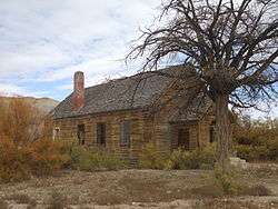
Abandoned former church/schoolhouse | |
 Caineville  Caineville Location of Caineville in Utah | |
| Coordinates: 38°19′59″N 111°01′08″W / 38.33306°N 111.01889°WCoordinates: 38°19′59″N 111°01′08″W / 38.33306°N 111.01889°W | |
| Country | United States |
| State | Utah |
| County | Wayne |
| Settled | 1882 |
| Founded by | Elijah Cutler Behunin |
| Named for | John Thomas Caine |
| Elevation[1] | 4,600 ft (1,400 m) |
| Time zone | Mountain (MST) (UTC-7) |
| • Summer (DST) | MDT (UTC-6) |
| ZIP code | 84775 |
| Area code(s) | 435 |
| GNIS feature ID | 1426269[1] |
| Historical population | |||
|---|---|---|---|
| Census | Pop. | %± | |
| 1900 | 131 | — | |
| 1910 | 38 | −71.0% | |
| 1920 | 67 | 76.3% | |
| 1930 | 71 | 6.0% | |
| 1940 | 68 | −4.2% | |
| 1950 | 20 | −70.6% | |
| Source: U.S. Census Bureau[2] | |||
Caineville is an unincorporated community in Wayne County, Utah, United States. It is located on Utah State Route 24, east of Capitol Reef National Park and west of Hanksville. The town was named after John Thomas Caine.[3] It was founded by Elijah Cutler Behunin, whom the LDS Church sent there in 1882 to open the area for settlement.[4]
References
- 1 2 "Caineville". Geographic Names Information System. United States Geological Survey. Retrieved March 31, 2014.
- ↑ "Census of Population and Housing". U.S. Census Bureau. Retrieved November 18, 2011.
- ↑ Hunt, Charles B.; Averitt, Paul; Miller, Ralph L. (1953). "Geology and Geography of the Henry Mountains Region, Utah". Professional Paper (228). U.S. Geological Survey: 21.
- ↑ Van Cott, John W. (1990). Utah Place Names. Salt Lake City: University of Utah Press. pp. 61–62. ISBN 0-87480-345-4.
External links
Municipalities and communities of Wayne County, Utah, United States | ||
|---|---|---|
| Towns | 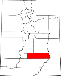 | |
| CDPs | ||
| Unincorporated communities | ||
| Ghost towns | ||
This article is issued from Wikipedia - version of the 11/12/2016. The text is available under the Creative Commons Attribution/Share Alike but additional terms may apply for the media files.