Byurakan
| Byurakan Բյուրական | |
|---|---|
|
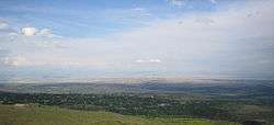
View of Byurakan as seen from the village of Tegher | |
 Byurakan | |
| Coordinates: 40°20′24″N 44°16′13″E / 40.34000°N 44.27028°ECoordinates: 40°20′24″N 44°16′13″E / 40.34000°N 44.27028°E | |
| Country | Armenia |
| Marz (Province) | Aragatsotn |
| Government | |
| • Mayor | Zarzand Babayan |
| Area | |
| • Total | 21.27 km2 (8.21 sq mi) |
| Elevation | 1,460 m (4,790 ft) |
| Population (2011) | |
| • Total | 4,345 |
| Time zone | (UTC+4) |
Byurakan (Armenian: Բյուրական), is a major village in the Aragatsotn Province of Armenia, located on the slope of Mount Aragats. The village is home to several historical sites including the 7th-century Artavazik Church, the 10th-century basilica of Saint Hovhannes and a huge 13th-century khachkar monument.
It is also home to the Byurakan Observatory.
Gallery
-
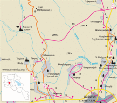
Road map of Byurakan and surrounding region.
-
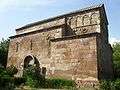
Basilica of S. Hovhannes of the 10th century
-

Artavazik Church of the 7th century with huge khachkar monument behind.
-

Huge khachkar monument behind Artavazik Church of the 13th century
-
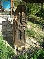
Pillar style khachkar with a Maltese Cross located behind a house in the village.
Nearby sites
Towns
Villages
Historical sites
- Amberd fortress
References
- Byurakan at GEOnet Names Server
- World Gazetteer: Armenia – World-Gazetteer.com
- Report of the results of the 2001 Armenian Census
- Kiesling, Rediscovering Armenia, p. 15, available online at the US embassy to Armenia's website

This article is issued from Wikipedia - version of the 11/23/2016. The text is available under the Creative Commons Attribution/Share Alike but additional terms may apply for the media files.