Mount Aragats
| Mount Aragats | |
|---|---|
 | |
| Highest point | |
| Elevation | 4,090 m (13,420 ft) [1][2] |
| Prominence | 2,143 m (7,031 ft) [3] |
| Listing |
Country high point Ultra |
| Coordinates | 40°32′00″N 44°12′00″E / 40.53333°N 44.20000°ECoordinates: 40°32′00″N 44°12′00″E / 40.53333°N 44.20000°E |
| Geography | |
 Mount Aragats Location in Armenia | |
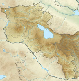
| Location | Aragatsotn Province and Shirak Province, Armenia |
| Parent range | Lesser Caucasus |
| Geology | |
| Age of rock | Holocene[1] |
| Mountain type | Stratovolcano |
| Last eruption | Unknown[1] |
| Climbing | |
| First ascent |
July 1843 Khachatur Abovian and Moritz Wagner[4] |
Mount Aragats (Armenian: Արագած, pronounced [aɾaˈgats]; formerly Ալագյազ, Alagyaz; Turkish: Alagöz) is an isolated four-peaked volcano massif in Armenia. Its northern summit, at 4,090 m (13,420 ft) above sea level, is the highest point of the Lesser Caucasus and Armenia. It is also one of the highest points in the Armenian Highlands.[lower-alpha 1]
The Aragats massif is surrounded by Kasagh River on the east, Akhurian River on the west, Ararat plain on the south and Shirak plain on the north.[2] The circumference of the massif is around 200 km (120 mi),[10][9] and covers an area of 6,000 km2 (2,300 sq mi)[11] or around 1⁄5 of Armenia's total area.[lower-alpha 2] 944 km2 (364 sq mi) of the massif is located above 2,000 m (6,600 ft).[13]
Etymology and names
The name of the mountain is less often spelled Aragatz or Aragac. According to Armenian tradition, Aragats originates from the words Արա Ara + գահ gah, which translates to "Ara's throne". Ara refers to the legendary hero Ara the Beautiful.[5][14] Aragats was mentioned by the early medieval historian Movses Khorenatsi. In his History of the Armenians Khorenatsi claims that the mountain is named after Aramaneak, the son of Hayk, the legendary father of the Armenian people. Aramaneak called his possessions "the foot of Aragats" (classical Armenian: ոտն Արագածոյ, otn Aragats'oy; modern: Aragatsotn).[15][16] The modern Aragatsotn Province, dominated by the mountain, was formed in 1995.[17]
A relatively modern name for the mountain is Alagöz, which literally means "variegated eye"[18] in Turkish.[19][20] This term was widely used up until the mid-20th century in European,[21] Tsarist Russian,[22] and early Soviet[20][23] sources. A variant of the word, Alagyaz (Ալագյազ), was used in Armenian.[9][24][25][lower-alpha 3] A village on the foot of Aragats is named Alagyaz.
Geography and geology
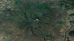

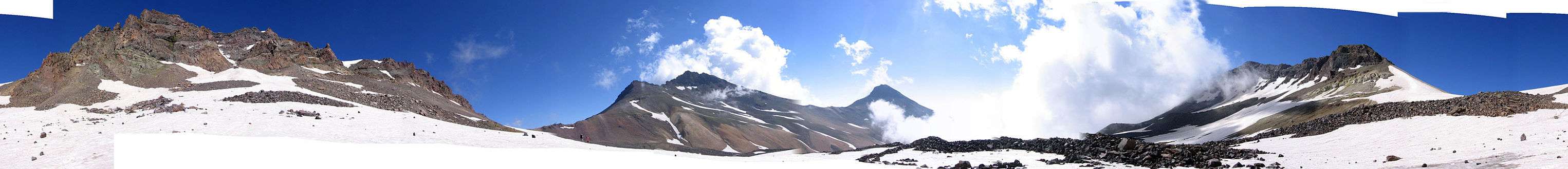
Aragats is isolated from Armenia's other mountain ranges.[27] However, it is considered part and the highest point of the larger Lesser Caucasus mountain range.[28][29] It has four summits, which are named according to their relative geographic position:[5]
- Northern—4,090 m (13,420 ft)
- Western—3,995 m (13,107 ft)
- Eastern—3,908 m (12,822 ft)
- Southern—3,888 m (12,756 ft)
Situated 40 kilometres (25 mi) northwest of Armenian capital Yerevan, Aragats is a large volcano with numerous fissure vents and adventive cones. Numerous large lava flows descend from the volcano and are constrained in age between middle Pleistocene and 3,000 BCE. The summit crater is cut by a 13 kilometres (8.1 mi) long line of cones which generated possibly Holocene-age lahars and lava flows.[1] The volcanic system covers an area of 5,000 km2 and is one of the largest in the region. More recent activity in flank centres occurred in Tirinkatar (0.48-0.61 Ma), Kakavasar, (0.52-0.54 Ma) and Ashtarak (0.58 Ma), as well as Jrbazhan in the summit area (0.52 Ma). The magmas feeding Aragats are unusually hot for arc-derived magmas, resulting in long and voluminous lava flows.[30]
Glaciation
Observations shortly after World War II showed the presence of firn fields and snowfields on the sides of the crater cirque, as well as moraines and glaciers inside the crater. An analysis in 1896 indicated a surface area of 5.5-5.8 km2, but rapidly retreated afterwards. The glaciation has been retreating on account of insufficient snowfall and increasing temperatures. Glacial meltwater dominates the upper part of the rivers descending from Aragats but its importance decreases farther down the valleys.[31] Traces of prehistorical glaciation also exist, including thick moraines in the summit area at an altitude of 2,600-3,000 m.[32]
History
Geological
The volcano was constructed within four different phases. The first phase (possibly 2.5Ma) occurred in the main crater and subsidiary vents and was basaltic andesite in composition. It crops out in deep gorges. The second phase (0.97–0.89 Ma, by K-Ar) involved the main vent, subsidiary structures and was basaltic and andesitic in composition with ignimbrites and pyroclastics, with tuffs and lava flows emanating from satellite centres. It was the most voluminous and included the Shamiram and Egvard subsidiary centres. The third phase (0.74–0.68 Ma) while similar to the second was more restricted in regional extent to the Mantash River basin. The fourth stage (0.56–0.45 Ma) involved mafic lava flows from parasitic vents in the southern parts of the volcano.[33]
Cultural
- Rock art
Numerous engravings have been around the volcano, including rock paintings portraying animals and human-like figures in Kasagh River valley possibly of early Holocene age, and in Aghavnatun on the southern side of the volcano including petroglyps showing animals that were possibly created in the 4th to 1st millennia BCE.[34]
- Legends
According to an ancient Armenian legend, Aragats and Mount Ararat were loving sisters who parted after a quarrel and separated permanently. Currently, the mountains are further separated politically, with Mt. Ararat being located in Turkey.[35]
Another legend tells that Gregory the Illuminator, who converted Armenia into Christianity in the early 4th century, "used to pray on the peak of the mountain. At nighttime an icon-lamp shone to give light for him, the lamp hanging from heaven using no rope. Some say that the icon-lamp is still there, but only the worthy ones can see it."[35]
- 2005 Dance of Unity
On May 28, 2005—the anniversary of the establishment of the First Republic of Armenia—around 250,000 people participated in a Dance of Unity (Armenian: Միասնության շուրջպար) around Mount Aragats in a mass display of national unity. The quarter million participants, among them then-President Robert Kocharyan, formed a 163-kilometre (101 mi) ring around the mountain.[36][37] The organizers hoped the event would be included in the Guinness World Records.[38] Prior to the dance, some 110,000 trees were planted on the slopes of Aragats.[39]
Nearby settlements
The following settlements are located on the slopes or foot of Aragats: Ashtarak,[40] Artik, Aparan, Talin, Oshakan, Byurakan.
Landmarks

 Alphabet park
Aragats has historically played a significant role in Armenian history and culture. Numerous historical and modern monuments are located on its slopes, some of which are listed below.[35]
The 4th century mausoleum of the Arsacid (Arshakuni) dynasty is located in the village of Aghtsk, on the slopes of Aragats.[35]
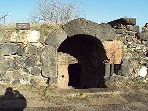
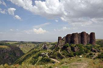
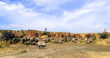
The early medieval fortress of Amberd and the nearby 11th century Vahramashen Church are located on the slopes of Aragats, at an altitude of 2,300 m (7,500 ft).[41] One source calls Amberd the "biggest and the best preserved fortress" in modern-day Armenia.[42]
The Byurakan Observatory, established in 1946 by Victor Ambartsumian, is located on the southern slopes of Aragats, near the village of Byurakan, at an altitude of 1,405 m (4,610 ft).[43] It made Armenia one of the world's centers for the study of astrophysics in the 20th century.[44]
The Alphabet Park (տառերի պուրակ, lit. "park of the letters") is located near the village of Artashavan. It was founded in 2005 on the 1600th anniversary of the invention of the Armenian alphabet. It features sculptures of the 39 letters of the Armenian alphabet and statues of notable Armenians, such as Mesrop Mashtots (the inventor of the alphabet), Armenia's national poet Hovhannes Tumanyan, Khachatur Abovian (father of modern Armenian literature), and others.[45] In 2012 a 33-metre (108 ft) high cross, composed of 1711 large and small iron crosses, symbolizing the number of years since Armenia's conversion to Christianity in 301, was installed on a hill near the park. A cross is added on an annual basis.[46]
In culture
.png)
Mt. Aragats plays a special role in Armenian history and culture. Along with Ararat, it is considered a sacred mountain for the Armenians.[35]
Aragats is a male first name in Armenia, used especially in areas surrounding the mountain.[lower-alpha 4]
Mt. Aragats is often associated with Gyumri, Armenia's second largest city. The mountain is depicted on the coat of arms of Gyumri.[49] It is also depicted on the obverse side of the 10,000 Armenian dram banknote (in use since 2003) in the background of Avetik Isahakyan, a poet born in Gyumri.[50]
- Literature
Numerous Armenians poets (e.g. Avetik Isahakyan)[11][51] have written about Aragats. Marietta Shaginyan compared Aragats to a "half-open bud of a giant pomegranate flower".[52] In one short poem Silva Kaputikyan compares Armenia to an "ancient rock-carved fortress", the towers of which are Mount Aragats and Mount Ararat.
- Paintings
Numerous artists have painted Aragats. Some examples of paintings of Aragats kept at the National Gallery of Armenia include:
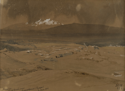 Grigory Gagarin, 1842
_%D4%B3%D6%87%D5%B8%D6%80%D5%A3_%D4%B2%D5%A1%D5%B7%D5%AB%D5%B6%D5%BB%D5%A1%D5%B2%D5%B5%D5%A1%D5%B6.jpg) Gevorg Bashinjaghian, 1905
Gevorg Bashinjaghian, 1905_%D4%B5%D5%B2%D5%AB%D5%B7%D5%A5_%D4%B9%D5%A1%D5%A4%D6%87%D5%B8%D5%BD%D5%B5%D5%A1%D5%B6.jpg) Yeghishe Tadevosyan, 1917
Yeghishe Tadevosyan, 1917 Hmayak Hakobian (1871-1939), date unknown
 Panos Terlemezian (1865-1941), date unknown
Gallery

See also
References
- notes
- ↑ Because the Armenian Highlands is not a well-defined area, sources vary greatly on where Aragats ranks. Some sources call it the second highest (after Mount Ararat in Turkey),[5][6] others the third highest (after Ararat and Süphan, also in Turkey)[7][8] and some the fourth highest (after Ararat, Sabalan in Iran, and Süphan).[9]
- ↑ Armenia's territory is 29,743 km².[12] 6,000 is its 20.2%.
- ↑ A folk song from Shirak composed by Komitas is titled Alagyaz.[26]
- ↑ Two examples of notable people named Aragats include Aragats Akhoyan, member of the parliament, born in Dzorap.[47] and Aragats Mkrtchyan, a veteran of the Nagorno-Karabakh War, from Talin.[48] Both of these settlements are located in the Aragatsotn Province.
- references
- 1 2 3 4 "Aragats". Global Volcanism Program. Smithsonian Institution.
- 1 2 Հայաստանի Հանրապետության Ֆիզիկաաշխարհագրական օբյեկտների համառոտ տեղեկատու-բառարան [Dictionary of Physical-Geographic Objects in the Republic of Armenia] (PDF) (in Armenian). State Committee of the Real Estate Cadastre. 2007. p. 15.
- ↑ "High prominence mountains in Caucasus and Russia outside of Europe.". ii.uib.no. Institutt for informatikk University of Bergen.
- ↑ Ketchian, Philip K. (December 24, 2005). "Climbing Ararat: Then and Now". The Armenian Weekly. 71 (52). Archived from the original on September 8, 2009.
- 1 2 3 "Արագած". armgeo.am (in Armenian). Armenian Geographic. 27 May 2015.
- ↑ Aslani︠a︡n, A. T. (1973). "Yerevan-Southern Summit of Aragats Volcano". Guide-book of Excursions of the All-union Conference for the Study of the Quaternary Period: Armenian SSR. Academy of Sciences of the Armenian SSR Institute of Geological Sciences. p. 72.
By its height among the highest peaks of the Armenian highland Aragats gives way only to Ararat — the famous biblical mountain that rises for more than 1 km.
- ↑ Hewsen, Robert H.; Anania Shirakatsi (1992). The Geography of Ananias of Širak: Ašxarhacʻoycʻ, the Long and the Short Recensions. Reichert. p. 217. ISBN 9783882264852.
The highest peak in the Armenian SSR, Aragac is the third highest mountain on the Armenian plateau after Ararat (16,916 ft. /5172 m), and Sip'an (Subhan, 14,543/4434).
- ↑ Smith, Adam T. (2009). "Regional Investigations in the Tsaghkahovit Plain: Orientation and Methodology". The Foundations of Research and Regional Survey in the Tsaghkahovit Plain, Armenia. Oriental Institute of the University of Chicago. p. 95. ISBN 9781885923622.
Aragats is the third highest peak in the Armenian Highland after Great Ararat (5,165 m a.s.l.) and Süphan Dağı (4,434 m a.s.l.).
- 1 2 3 Nazarian, Kh. (1974). "Արագած (Aragats)". Soviet Armenian Encyclopedia Volume I (in Armenian). p. 677–678.
- ↑ Adalian 2010, p. 3.
- 1 2 "Արագած (Aragats)". encyclopedia.am (in Armenian). Armenian Encyclopedia. Archived from the original on March 14, 2016.
- ↑ "Armenia". The World Factbook. Central Intelligence Agency.
- ↑ Martirosyan 2013, p. 127.
- ↑ "Արագած". encyclopedia.am (in Armenian). Armenian Encyclopedia.
ՙԱրագած՚ անվանումը, ըստ ավանդության, ծագել է ՙԱրա՚ անունից և ՙգահ՚ բառից: Ասել է թե՝ Արայի գահ (խոսքը Հայոց թագավոր Արա Գեղեցիկի մասին է):
- ↑ Moses of Khoren (1978). History of the Armenians. Robert W. Thomson (translator). Harvard University Press. pp. 89–90.
- ↑ Harutyunyan, Sargis (1987). "Հերոսներ (Heroes)". Հայ հին վիշապաշխարհը (Armenia's ancient world of vishaps) (in Armenian). Yerevan: Arevik. pp. 45–46.
- ↑ Holding, Deirdre (2014). Armenia: with Nagorno Karabagh. Bradt Travel Guides. p. 159. ISBN 978-1841625553.
Aragatsotn Province. The province whose name means 'foot of Aragats' comprises the land around Mount
- ↑ "Алагез (Alagez)". Small Brockhaus and Efron Encyclopedic Dictionary (in Russian).
Алагез (пестрый глаз), потухш. вулкан в Ереванской губернии, 13490 ф. Богат. месторождения серы.
- ↑ Barnett, R. D. (1982). "Urartu". Cambridge Ancient History Volume III (second ed.). Cambridge University Press. p. 318. ISBN 0521224969.
...slopes of Mount Aragats (modern Turkish Alagoz).
- 1 2 "How Ordzhonikidze Helped Save a Framed Engineer". The Current Digest of the Soviet Press. American Association for the Advancement of Slavic Studies. 16: 15. 1964.
In July, 1928, on an assignment from my editors, I was climbing the extinct volcano in Armenia [Mt. Aragats] that at the time still bore its Turkish name, Alagoz.
- ↑ Lynch, H. F. B. (1901). Armenia, travels and studies. Volume I: The Russian Provinces. London: Longmans, Green, and Co. p. 122.
- ↑ "Алагёз". Brockhaus and Efron Encyclopedic Dictionary Volume I (in Russian). 1890. p. 347.
- ↑ "Алагез [Alagez]". Soviet Military Encyclopedia Volume I (in Russian). 1932. p. 387.
Алагез (армян. Арагац), изолированный горный массив в ССР Армении к С.-З. от г. Эривань.
- ↑ Der Nersessian, Sirarpie (1969). The Armenians. New York: Praeger. p. 11.
...the Alagoz (Aragats, 4180 m.) to the North of Mount Ararat...
- ↑ Melikset-Bek, Levon (1956). "Ի. Գրիշաշվիլին և հայ գրականությունը". Bulletin of the Academy of Sciences of the Armenian SSR: Social Sciences (in Armenian) (2): 29.
Ավ. Իսահակյանն [...] հայ բանաստեղծի շրթերում հնչում է Ալագյազ-Արագածը...
- ↑ Sargsyan, Arpine (22 February 2011). "Alagyaz". culturalcaucasus.org. Cultural Caucasus.
- ↑ "Researching Forest Raptors on Armenia's Highest Peak". Russian Conservation News (35-42): 32. 2004.
At 4,090 meters above sea level, Mt. Aragats is Armenia's tallest mountain massif. It is located in the central part of the republic, in Aragatsotn Region, where it is isolated from the rest of the country's mountain ranges.
- ↑ "Mount Aragats". Encyclopædia Britannica.
The highest point in both Armenia and the Lesser Caucasus range...
- ↑ Encyclopedia Americana: Cathedrals to Civil War. Scholastic Library Publishing. 2005. p. 86. ISBN 9780717201389.
The highest point within the Armenian part of the Lesser Caucasus is Mt. Aragats...
- ↑ Meliksetian, Khachatur; Savov, Ivan; Connor, Charles; Halama, Ralf; Jrbashyan, Ruben; Navasardyan, Gevorg; Ghukasyan, Yura; Gevorgyan, Hripsime; Manucharyan, Davit; Ishizuka, Osamu; Quidelleur, Xavier; Germa, Aurélie (2014). "Aragats stratovolcano in Armenia - volcano-stratigraphy and petrology". Geophysical Research Abstracts. 16.
- ↑ Davoyan, M.O. (1971). "Area of modern glaciation on Mt. Aragats and the diminution of firn basins". International Geology Review. 13 (4): 530–533. doi:10.1080/00206817109475464. ISSN 0020-6814.
- ↑ Maisuradze, G.M. (1989). "Anthropogene of the anticaucasus". Palaeogeography, Palaeoclimatology, Palaeoecology. 72: 53–62. doi:10.1016/0031-0182(89)90131-4. ISSN 0031-0182.
- ↑ I.V. Chernyshev; V. A. Lebedev; V. A. Lebedev; M. M. Arakelyants; M. M. Arakelyants; R. T. Jrbashyan; R. T. Jrbashyan; Yu. G. Gukasyan; Yu. G. Gukasyan (May 2002). "Quaternary geochronology of the Aragats volcanic center, Armenia: Evidence from K-Ar dating". Doklady Earth Sciences. 384 (4): 393–398.
- ↑ Khechoyan, Anna (24 May 2007). "The Rock Art of the Mt. Aragats System". Centro camuno di studi preistorici.
- 1 2 3 4 5 Abrahamian, Levon (2007). "Dancing around the mountain: Armenian identity through rites of solidarity". In Grant, Bruce; Yalçın-Heckmann, Lale. Caucasus Paradigms: Anthropologies, Histories and the Making of a World Area. Berlin: Lit Verlag. pp. 167–188. ISBN 9783825899066.
- ↑ "Armenian people united around Aragats mountain". PanARMENIAN.Net. 28 May 2005. Retrieved 20 June 2013.
- ↑ "Միասնության շուրջպարը գրկեց Արագած լեռը" (in Armenian). Armenpress. 28 May 2005.
- ↑ Vardanian, Gegham (2 June 2005). "Armenia's Big Dance". Institute for War and Peace Reporting.
- ↑ "Մի ֆոտոյի պատմություն. միասնության շուրջպար". 1tv.am (in Armenian). Public Television of Armenia. 28 May 2015. Archived from the original on April 29, 2016.
- ↑ Kaeter, Margaret (2004). The Caucasian Republics. Infobase Publishing. p. 68. ISBN 9780816052684.
In between Gyumri and Yerevan lies Mount Aragats, the highest mountain currently in Armenia, at about 14,000 feet. Ashtarak, the closest town of any size, has 20,000 people...
- ↑ Ghafadaryan, K. (1974). "Ամբերդ (Amberd)". Soviet Armenian Encyclopedia Volume I (in Armenian). p. 278–280.
- ↑ "Ashtarak-Oshakan-Amberd fortress–Letter Park". wonderlandarmenia.com. 2014.
- ↑ "History of the Byurakan Astrophysical Observatory". aras.am. Armenian Astronomical Society. Archived from the original on April 29, 2016.
- ↑ Adalian 2010, p. 354.
- ↑ "Հայոց այբուբենի հուշարձան". hyurservice.com (in Armenian). Hyur Service.
- ↑ Mkrtchyan, Anush (20 October 2012). "Տառերի պուրակում տեղի ունեցավ 33 մետրանոց Սուրբ խաչի բացումը". azatutyun.am (in Armenian). Radio Free Europe/Radio Liberty.
- ↑ "Aragats Akhoyan". parliament.am. National Assembly of the Republic of Armenia.
- ↑ "Յուրաքանչյուր մարտ մի քանի րոպեում ես հաղթում. Արագած Մկրտչյան". razm.info (in Armenian). Armenian Ministry of Defense. 23 August 2013.
- ↑ "Symbols of Gyumri". gyumricity.am. Gyumri Municipality.
- ↑ Cuhaj, George S. (2015). Standard Catalog of World Paper Money, Modern Issues, 1961-Present. F+W Media, Inc. p. 63. ISBN 9781440244117.
- ↑ Արագածին
- ↑ Mikhaĭlov, Nikolaĭ Nikolaevich (1988). A Book About Russia: In the Union of Equals: Descriptions, Impressions, the Memorable. Progress Publishers. p. 109.
Aragats, the highest mountain in Armenia, rises with its split white cone, like the half-open bud of a giant pomegranate flower, to use the words of the well-known Soviet writer Marietta Shaginyan.
- bibliography
- Adalian, Rouben Paul (2010). Historical Dictionary of Armenia. Lanham, Maryland: Scarecrow Press. ISBN 978-0-8108-7450-3.
- Martirosyan, Levon M. (2013). "Արագած լեռնազանգվածի ռեկրեացիոն ռեսուրսները եվ դրանց գնահատումը (Recreational Resources and Mountain Mass Evaluation of Aragats)" (PDF). Scientific Proceedings (in Armenian). Gyumri State Pedagogical Institute (2): 125–132. Archived from the original on April 29, 2016.
| Wikimedia Commons has media related to Mount Aragats. |